
Figure 20 Lost Creek Junction
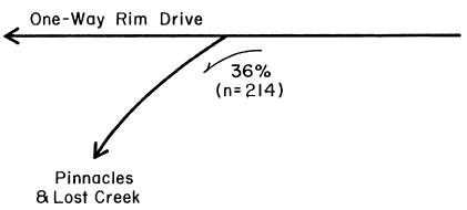
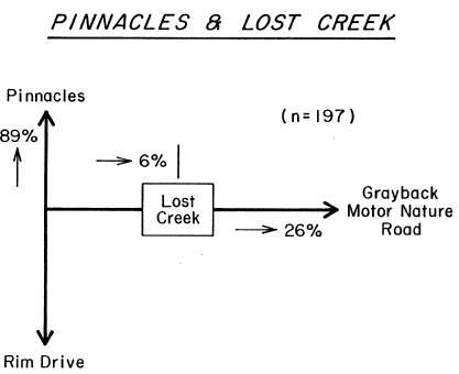
Figure 21. Pinnacles and Lost Creek.
Traffic patterns on Rim Drive are summarized in Figure 22. About 60-70% of park visitors travel the section of road between Rim Village and North Junction, making this the most heavily used segment. The road to Cleetwood Cove is used by 25-30% of all visitors, and the one-way portion is used by 20-25%. About 15% use the Cloud Cap Spur, and less than 10% use the Pinnacles and Grayback Roads.
USE OF RIM DRIVE PULL OUTS
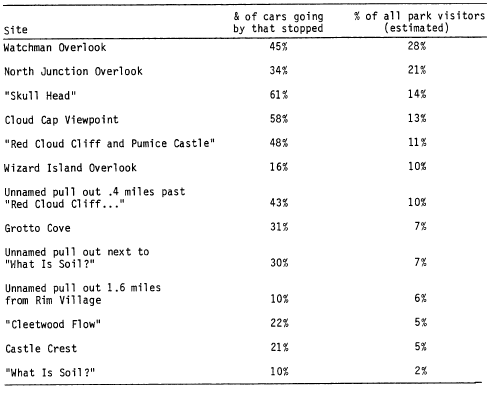
The percentages of visitors using different pull outs around Rim Drive are shown in Table 6. The left column shows the percent of cars going by that stopped, while the right column gives an estimate of the percent of all park visitors using this area (estimates are based on the road traffic estimates discussed earlier). The most used pull outs are the Watchman (28% of all visitors) and North Junction (21%) overlooks.
IMPLICATIONS FOR MANAGEMENT
Distribution patterns show that Rim Village and the Rim Village-North Junction road are centers of visitor activity, which is no surprise. More surprising is the low proportion of park visitors who get around the lake to Cleetwood Cove (approximately 28%) or the one-way portion of Rim Drive (approximately 22%). Pull outs on the one way section receive very little use. These findings are important in two ways. First, they show where the most people can be reached with interpretive information given current use distributions, perhaps providing a basis for allocating money and effort. Second, they show which areas are currently “off the beaten track.” If managers feel that visitors should see such places as the one-way portion of Rim Drive, it might be possible to direct more people to those areas.
Figure 22. Traffic Patterns on Rim Drive.
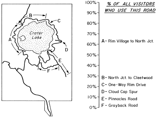
Table 6. Use of Rim Drive Pull Outs.
***previous*** — ***next***