
Getting to the bottom of things at Crater Lake National Park
WILLIAM M. BROCK, Crater Lake National Park, P.O. Box 7, Crater Lake, Oregon 97604; mac_brock@nps.gov
***previous*** — ***next***
getting-bottom-things pdf file
Crater Lake National Park is located in southwestern Oregon on the divide of the Cascade Mountains. It lies in an area with a long history of volcanic and glacial activity, extending from Lassen Peak in northern California northward into Canada.
In the middle of the park is Crater Lake, which formed about 7,700 years ago after the climatic eruption of Mount Mazama. The lake occupies the collapsed caldera of the mountain. The lake is 7 to 9.5 km (4.5 to 6 mi) across, has 32 km (20 mi) of shoreline, a surface area of 5,339 ha (13,192 acres), and a depth of 597 m (1,958 ft) at its deepest point, making it the deepest lake in the USA. Annually, about 500,000 visitors come to see the famous deep blue lake.
getting-bottom-things 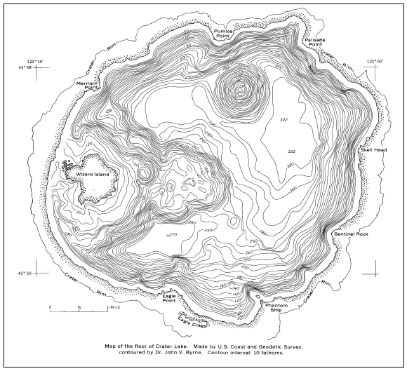 Figure 7.1. Map of the floor of Crater Lake. U.S. Coast and Geodetic Survey, 1959.
Early scientists were not content to merely gaze at the sublime beauty of the lake. They longed to know what lay beneath. In 1886, the Dutton expedition, made up of scientists from the U.S. Geological Survey (USGS), came to Crater Lake to take the first-ever measurements of its depth at various locations. In a rowboat dubbed the “Cleetwood,” using a lead-weighted spool of piano wire with leather tabs attached to record depth, they took about 100 measurements and recorded a maximum depth of 1,996 ft (Dutton 1886).
Others followed and, in 1956, the USGS used echo sounding to map the lake bottom based on about 5,000 measurements (Byrne 1962). Until recently, that map (Figure 7.1) formed the basis for understanding the geomorphology of the lake’s bottom. Their map identified three distinct deep basins. They identified a platform formed by the eruption of Wizard Island. They discovered the submerged Merriam cone and they measured the deepest point at 1,932 ft. More detail of the geologic features would have to wait for technology to progress to the point of getting the additional precision that managers and scientists wanted. Furthermore, significant funding would be needed to attempt such a project. For some time this project remained just another “nice to do” item documented in the park’s resource management plan. However, two subsequent unrelated events provided an opportunity to move forward on this project.
On September 23, 1995, a tragic accident happened in the park. A corporate helicopter flew into the park and down into the Crater Lake caldera. The aircraft crested the caldera rim anywhere from 700-2,000 feet above the surface of Crater Lake. According to eyewitness accounts, the aircraft circled near Wizard Island at approximately 350 ft above the lake level and then flew in a southeasterly direction toward the Crater Lake Lodge. The aircraft slowly descended while it flew toward the Crater Lake Lodge until it hit the lake surface, tumbled, broke up and sank quickly in approximately 1,500 ft of water. The pilot and passenger died in the accident.
A fuel slick was observed on the surface of the lake from approximately 70 gallons of liberated jet fuel on board the aircraft. Other solid waste (Styrofoam and floating aircraft debris) was collected from the lake for about a week after the accident. A limited amount of other lubricants such as transmission fluids and engine oils may have been liberated or may still be encased in the wreckage that sank.
The park staff had a dilemma. What do you do about helicopter wreckage in 1,500 feet of water? Title 36 Code of Federal Regulations Section 2.17 offered some guidance:
c(1) …the owners of a downed aircraft shall remove the aircraft and all component parts thereof in accordance with procedures established by the superintendent. In establishing removal procedures, the superintendent is authorized to: (i) Establish a reasonable date by which aircraft removal operations must be complete; (ii) determine times and means of access to and from the downed aircraft; and (iii) specify the manner or method of removal.
c(3) The superintendent may waive the requirements of paragraph (c)(1) of this section or prohibit the removal of downed aircraft, upon a determination that: (i) The removal of downed aircraft would constitute an unacceptable risk to human life; or (ii) the removal of a downed aircraft would result in extensive resource damage; or (iii) the removal of a downed aircraft is impractical or impossible.
The Crater Lake superintendent elected to require the helicopter company to conduct a feasibility analysis to salvage the wreckage. It estimated that the cost of salvage would exceed $1 million. Its analyses found that such a salvage operation would be impractical and too risky, and would further damage park resources (Irvin 1996).
Although park managers did not concur in all of the company’s findings, the park superintendent decided that present understanding did not support a conclusion that an acute or chronic environmental problem was posed by the aircraft wreckage. The ongoing impact to the lake was primarily one of the aesthetic damage due to the wreckage. Park managers agreed that the benefits associated with recovery did not outweigh the risks.
Nevertheless, it seemed wrong to absolve the company from any responsibility for the damage to the park’s natural resources. Park managers believed that the company should somehow be held accountable for damage to the park, even if it was accidental. Consultation with the National Park Service (NPS) Environmental Response, Planning and Assessment Division suggested a possible remedy through a recently passed act.
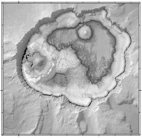
Figure 7.2. Preliminary bathymetric image of Crater Lake. U.S. Geological Survey, 2000.
In 1990 Congress passed the Park System Resource Protection Act (P.L. 101-337, 16 USC 19jj). The law allows NPS to seek compensation for damages and to retain those monies, without further appropriation, to restore, replace, or acquire equivalent resources. Under the statute, NPS can also collect any costs associated with responding to and assessing the damages related to such incidents, including monitoring. Money recovered as past costs or for future assessment or restoration work are placed in an investment account that earns interest until used.
The Resource Protection Act is a tool for protecting and restoring park resources. It is not a regulatory tool. It is compensatory, not punitive. The goal of the law is to restore damage and make the park whole, not to punish. However, the law is also a strict liability law that means a manager does not need to demonstrate negligence but only that damage occurred from an action of another party.
A second event happened in the summer of 1998. Secretary of the Interior Bruce Babbitt visited Crater Lake and discussed our ongoing lake research program. Babbitt informed the park of a research project to map the bottom of Lake Tahoe that USGS had completed using a new multibeam sonar system. The system was highly precise and produced a high-resolution map (Gardner et al. 1998). The contact spawned interest by the USGS to conduct a similar survey at Crater Lake; however, there was no funding for the project.
From these events, park managers began to see a way that we could partner with the USGS and the Department of the Interior Solicitor’s Office to acquire the technology and the funds to search for the helicopter and assess the crash site and simultaneously map the lake bottom.
The civil case took some time. The helicopter crashed in 1995 and the Solicitor’s Office successfully settled the case in 1999. We started the project in the summer of 2000.
NPS transferred funding to USGS to conduct the project by means of an interagency agreement. USGS in turn used a cooperative agreement it had established with the University of New Hampshire to acquire the professional expertise and engage a contractor from Louisiana who owned the sonar technology. The research vessel and sonar equipment were trucked to Crater Lake to begin the project. Access to the lake surface is limited to a foot trail. Park managers obtained approval from the Pentagon and enlisted the services of the U.S. Army Reserves from Fort Lewis, Washington, to transport the research vessel 1,000 feet from the caldera rim to the lake surface. Once there, it took only five days to complete the search for the helicopter crash site and survey of the lake bottom.
This project attracted significant media attention. Park managers used the opportunity to promote the project. The project’s discoveries were shared through a media campaign that focused on the technology and the scientific contributions of the survey. Throughout the period of the survey park staff made 74 media contacts. As a result, the project was covered repeatedly on television, radio, and newspapers throughout the NPS Pacific West Region as well as in newspapers in the Rocky Mountains and Midwest. The park’s message was delivered to over a million individuals, based on the reported viewing audiences of and subscribers to those local stations and newspapers which ran spots and articles on the events of the survey. This is analogous to reaching twice the park’s annual visiting public with a very focused message of “parks as laboratories.”
Even though we did not locate the helicopter itself, the survey of the lake bottom was extremely worthwhile. The new images revealed incredible details of ancient lava flows, huge landslide debris fields, newly discovered vents, ancient lakeshores, and other fascinating geologic features (Figure 7.2). Park managers anticipate that the Crossing boundaries on the ground through partnerships information from these new data will launch the park into a new era of scientific investigations about the lake and its volcanic origins.
Although the survey phase of this project is now complete, the park will continue to reap the benefits of this research for years, if not decades, to come. In the near future these data will be made available to interested scientists. The park’s Natural History Association is interested in obtaining the final map and brochure from the data as a future sales item. And in addition to providing the map data, USGS is interested in a future partnership to provide data and software to establish an interactive interpretive display for the park’s visitor center. The display will allow the visiting public to “explore” the bottom of Crater Lake electronically.
Lessons learned
There are several lessons that park managers learned through this process that will help prepare for future partnership opportunities.
-
Know what you need and write your needs down. It is important to take a broad and long look at what your park needs to manage its resources. There is value in developing and updating your resource management plans.
-
Market your program. Communicate your needs widely. To your superiors, your peers, other agencies, non-profits—to anyone who will listen. We need to do a better job of marketing what we are trying to do in resource management and actively solicit support from potential partners.
-
Network. Get to know a wide variety of folks who may help you out one day. And not just in your discipline—the majority of key players in this case study were not scientists or resource managers. They included attorneys from the Solicitor’s Office, NPS Washington Office support personnel, public information officers, military contacts, and agency program managers.
-
Be creative in meeting your needs. (Think outside the box.)
-
Don’t give up. Be persistent but be patient. (The rules were written for the box.)
-
Be prepared to seize or create opportunities.
-
Success leads to success. Use your successes to build credibility and momentum, and to develop new opportunities with new partners.
Conclusion
Born out of a civil settlement initiated five years ago, this project grew from an unlikely compact between attorneys, corporate executives, insurance adjusters, government officials, and research scientists. These results demonstrate that with perseverance, determination, shared vision, and a noble goal, we can accomplish extraordinary things.
References
Byrne, J.V. 1962. Bathymetry of Crater Lake, Oregon. The Oregon Bin 24:10, 161-164.
Dutton, C.E. 1886. Crater Lake, Oregon: a proposed national reservation. Science 7, 160, 179.
Gardner, J.V., L.A. Mayer, J. Hughes. 1998. The Bathymetry of Lake Tahoe, California–Nevada. USGS Open File Report 98-509. N.p.: USGS.
Irvin, J.F. 1996. Retrieval of N6099z A Eurocopter 3 AS-350 from Crater Lake National Park: Feasibility Study. Crater Lake, Ore.: National Park Service.
From Crossing Boundaries in Park Management: Proceedings of the 11th Conference on Research and Resource Management in Parks and on Public Lands,edited by David Harmon (Hancock, Michigan: The George Wright Society, 2001). © 2001 The George Wright Society, Inc. All rights reserved.
***previous*** — ***next***