
Rehabilitation of Highway 62 West, Crater Lake National Park, Klamath County, Oregon
INTRODUCTION
ISSUES AND IMPACT TOPICS
Wizard III Quarry, Rogue River National Forest
All fill and rock could be obtained from the existing 5.7-acre U.S. Forest Service Wizard III Quarry. The Wizard III Quarry is approximately 22 miles (driving distance) northwest of the project area in the Rogue River National Forest on Forest Road 6530 and 6535. The quarry has been used in the past as a rock source for U.S. Forest Service road construction. The quarry contains sufficient material for either of the action alternatives (K. Cook, FHWA 2002, pers. comm.). The construction contractor would also use the quarry site for batch mixing and as a staging area. Figure 3 shows the quarry and the excavation area that would be required for the action alternatives.
The quarry site is dominated by mountain hemlock forest. Use of the Wizard III Quarry would result in the removal of small stands of young ponderosa pine and Douglas-fir tree plantings from a previously logged forest community, resulting in a long-term, negligible, adverse effect. Expansion of the Wizard III Quarry would have no effect on threatened and endangered species (see appendix 3).
The forest archeologist has determined that this use is exempted from case-by-case study under the Programmatic Agreement (Northwest Forest Plan 1994, Appendix A) with the SHPO. Due to the nature of the proposed action, surveys would not be required (Hays, U.S. Forest Service, pers. comm. 2002). This area has also been previously logged (see appendix 3).
An asphalt batch plant and rock crushing unit would be located at the Wizard III Quarry. The operation of the batch plant and rock-crushing unit require an Oregon air discharge permit. Emissions would be regulated and controlled through permit stipulations. Effects to air quality would be short-term, negligible, and adverse.
Volcanic rocks, mostly andesite with small amounts of breccia, would be excavated and crushed to smaller sizes and to aggregate at the Wizard III Quarry site. It is estimated that 15,000-cubic yards of aggregate would be necessary for alternative B, and an estimated 35,000-cubic yards of aggregate would be necessary for alternative C. Approximately, 2 acres (0.8 hectare) of surface area (previously unexcavated soils) would be affected during quarry excavation activities. Most of the aggregate would be excavated from areas previously mined, rendering the quarry deeper. Approximately, 1.6 acres (0.6 hectare) of surface area (previously unexcavated soils) would be affected during quarry excavation activities. This would constitute a negligible, long-term, adverse effect to soils and geology at the quarry.
Use of the area would be in full compliance with the Rogue River National Forest Land and Resource Management Plan (1990) as amended by the Record of Decision for Amendments to Forest Service and Bureau of Land Management Planning Documents within the Range of the Northern Spotted Owl and attached Standards and Guidelines for Management of Habitat for Late-Successional and Old-Growth Forest Related Species within the Range of the Northern Spotted Owl (Northwest Forest Plan 1994). Therefore, further analysis of effects to the Wizard III Quarry site are not included in this environmental assessment.
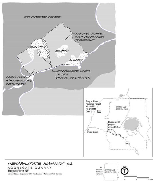
FIGURE 3. WIZARD III QUARRY [NPS-DSC\OCTO2\106\20133]
***previous*** — ***next***