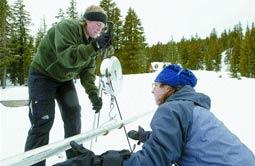
Streamflow signs buried in the snow
Herald and News
Klamath Falls, Oregon
February 1, 2005
By DYLAN DARLING
Deep in the snow 50 miles north of the Klamath Reclamation Project are buried the clues as to how much water the Project will get this summer.
Estimates on how much snow is in the mountain snowpack – and how much water will flow from it this summer – are vital to the Project and the Bureau of Reclamation’s ability to meet conflicting demands on Klamath Basin water. The figures are important enough for the Bureau to increase its role in collecting the data.
On Monday, Stephanie Painter, a water technician for the Bureau, used cross country skis to get to a clearing behind Crater Lake National Park headquarters and probe the snow with a long aluminum tube. The data she collected is one of the pieces federal forecasts will use to predict how much water will flow into Upper Klamath Lake from April to September. The lake is the Klamath Project’s primary reservoir.
As streamflow predictions have become more and more important to all the parties involved with Klamath water issues, more and more agencies have gotten involved with the collection of snowpack data. Also, more survey sites have been added, and more are on the way.
“We think the information is important, so we are willing to help out,” said Cecil Lesley, the Project’s water and land chief.
The Bureau has funded creation of four new automated snow-depth tracking sites in the Basin in the past five years and has plans for two more, officials said. Last year, the Bureau had two staffers go through the training needed to check snow survey sites.
The move was made to help the National Resource Conservation Service, the federal agency tasked with tracking snowpack numbers throughout the country and forecasting streamflows. The Conservation Service doesn’t have enough personnel to check all of the sites officials want checked.
For forecasters, the more snowpack data, the better.
Because the snowpack accounts for 70 to 75 percent of streamflow, snowpack data is the crux of the forecast that comes out, said Jon Lea, a hydrologist with the Conservation Service.
Before a site can be used in the forecasting formula, about five years of data, and the creation of averages, needs to be logged. Ringing the upper Basin there are 14 automated snow sites as well as four sites checked by plane and a half-dozen checked manually.
Some of the sites the Bureau has budgeted, including one along Annie Creek and one near Gerber Reservoir, will soon be in the forecasting fold, Lea said. And there are plans for more sites, he added.
The U.S. Geological Survey plans to put in sites near Sun Pass and Swan Lake.
“We are always looking for ways to fill the voids on the data-collection side of things,” Lea said.
On Monday, Painter was manually checking an established “snow course,” or a string of designated spots in an open area where snow depth measurements are taken. She was helped by a park ranger and a ski patrol volunteer. The site was established in 1959, and records have been kept every month since.
She tried to plunge the tube deep into the snow.
The tube stopped, half-stuck in the snow. She pulled it up a bit and put her weight into it. The tube cracked the ice layer and slid down to the ground.
Paydirt.
The bottom of the tube hit the topsoil several feet under the snow.
“Whoa, it’s deeper than I thought,” Painter said.
It turned out to be 86 inches – more than 7 feet deep.
At the weather station about a quarter-mile away, which is checked daily by a park worker, the snowpack was 50 inches.
After measuring the snow, the tube was weighed both full of snow and empty, then a calculation was made to see how dense the snow was. The more dense the snow, the more water it yields when it melts.
Throughout the course Painter, the ranger and the ski patroller repeat the process: Plunge. Measure. Weigh. Weigh.
The data at park headquarters and the five other manual sites will be used along with the machine-collected and human-checked data from the automated sites. An updated streamflow forecast will be out late this week or early next week.
It probably won’t be good news for Project farmers and ranchers, who are two months from the start of irrigation season.
As of Monday, the snowpack for the Basin’s automated sites read 48 percent of average for this time of year. At the start of January the forecast was for Upper Klamath Lake to get 78 percent of its average streamflow. The next forecast will probably be lower.
But – with some late-winter storms – things could change before April, said Jolyne Lea, another hydrologist for the Conservation Service and the wife of Jon Lea. And the past two years, the amount of streamflow actually coming into the lake was less than the amount forecast.
“Unfortunately, the Klamath is one of those sites where there can be a lot of error,” Lea said. “A lot of that just has to do with the Basin and the nature of the snowpack.”
She said having different terrain on different sides – such as the alpine Cascades on the west and desert plateaus on the east – makes it difficult to predict how much streamflow the snowpack will produce. Add to that changes in weather, thirsty or full aquifers and other factors and forecasting gets even more difficult.
For the Bureau, the most important forecast is as far off as the irrigation season.
“The April 1 forecast is the one on which we make the call on the water-year type, but all of them are important for us to plan where we are going in the water year,” Lesley said.
***previous*** — ***next***


