
Review: Geologic Map of Mount Mazama and Crater Lake Caldera, Oregon by Charles R. Bacon
Crater Lake Institute
July 7, 2009
by ROD CRANSON
Great source of geological material for teaching
 Crater Lake in south central Oregon fills one of the most spectacular calderas in the world. It is an 8-by-10-km basin more than a kilometer deep. USGS geologist Charlie Bacon has completed a 30 year study of this classic geologic area including field research, mapping, collecting, and dating the volcanic material in Crater Lake National Park , Oregon . Mount Mazama and the resulting Crater Lake Caldera is arguably the most thoroughly studied volcanic area in the United States , if not the world. Bacon’s work is now available in 4 beautiful colored geologic sheets (3 maps and a map unit correlation chart) plus a descriptive pamphlet.
Review of Geologic Map of Mount Mazama and Crater Lake Caldera, Oregon, 2008 by Charles R. Bacon; U.S. Geological Survey of the U.S. Department of the Interior; Scientific Investigations Map 2832 with descriptive pamphlet (45 pgs), ISBN 978-1-4113-1925-7, 4 sheets plus CD Database for the Geologic Maps; $19.00.
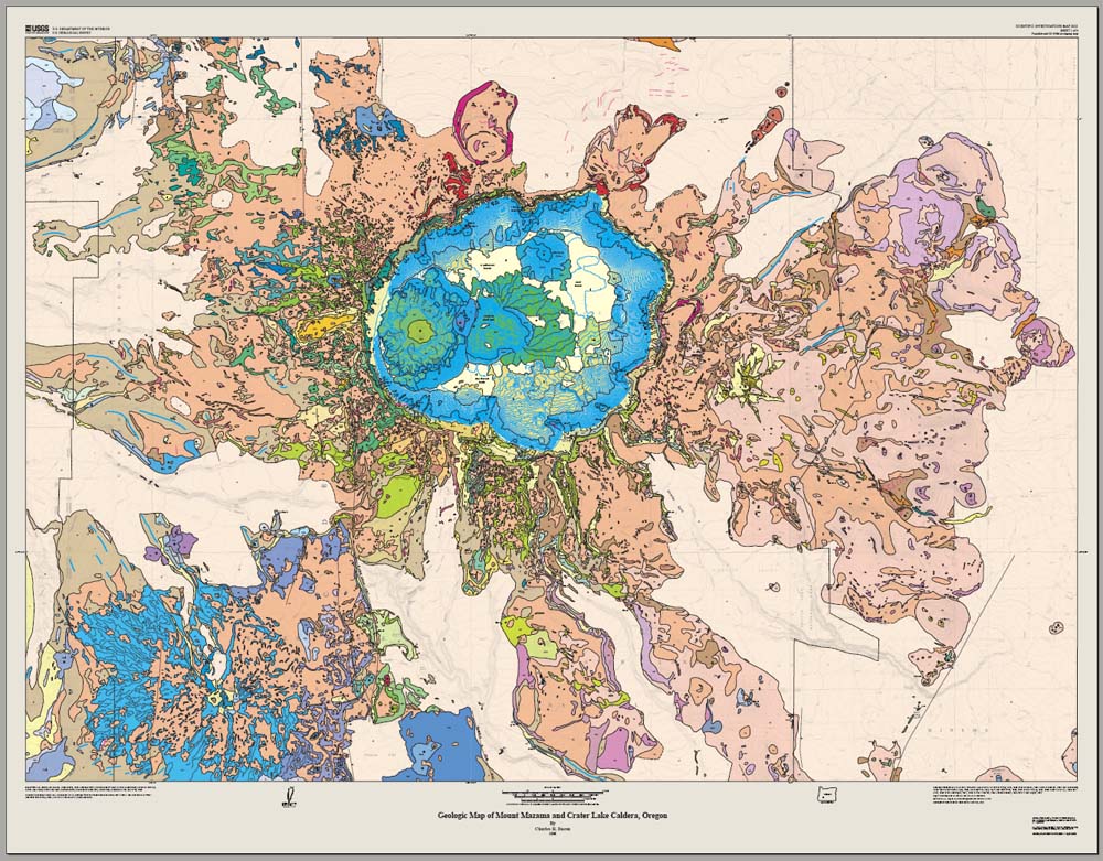
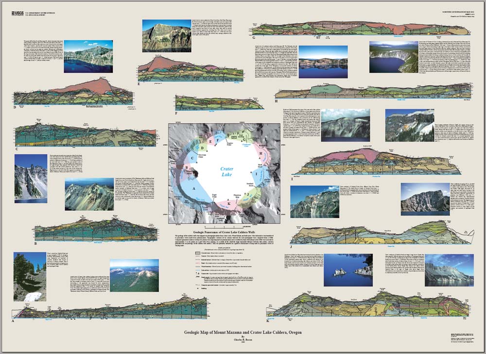
Bacon’s goal was to document the spatial distribution, volume, composition of eruptive products through time, evaluate potential natural hazards, and geothermal resources. Sheet 1 shows all the mapped surface rock units found in the park. In addition to the volcanic materials that compose the flanks of Mount Mazama and the climactic eruption ejecta, this map details the geology and history of the caldera floor in amazing detail. This caldera floor information adds significant details to the geologic history of the area that was not available before.
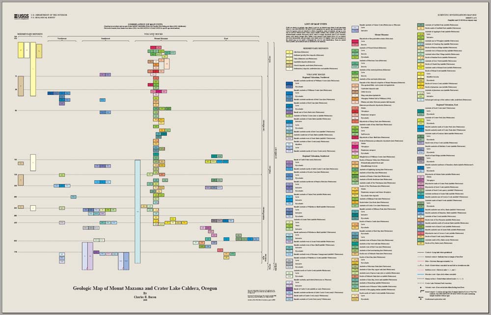
Sheet 2 details the igneous and sedimentary rocks that occur at Crater Lake National Park. All rock types are described in color with designation keys that correlate with the other three associated sheets. Symbols for dikes, faults, glacial features, volcanic vents, and dated sample locations are also indicated.
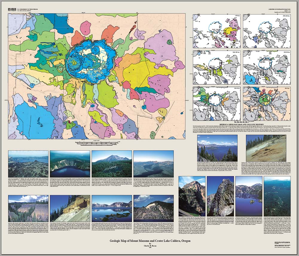
Sheet 3 is a combination of the larger map featured on sheet 1 and a series of bedrock geologic maps that illustrate and interpret the volcanic history of the area with brief interpretations. All are in color correlating with the rocks described on sheet 2. It also includes a set colored images of selected geologic features with brief descriptions of the geology shown.
Finally, sheet 4 is the most exciting and, perhaps, useful to teachers. It features a series of eleven Geologic Panoramas of Crater Lake Caldera Walls with associated images of the same portion of the wall. A brief description of the geology shown in the section and image is presented. A creative earth science teacher could use these sections and images to create a great lab activity for students to investigate the interior structure of a composite volcano. It should be possible to assembling the sections to build a model the geology of the Crater Lake Caldera wall – yielding a real example of the interior of an existing volcano.
This set of maps, accompanying pamphlet, and CD are available from the Crater Lake Natural History Association bookstore as Scientific Investigations Map 2832 for $19.95. They may also be downloaded from the USGS website.
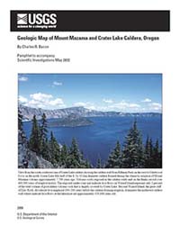
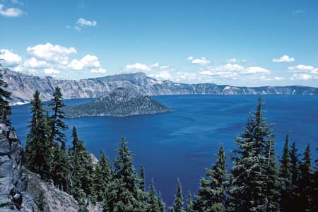 Crater Lake image – View from the south-southwest rim of Crater Lake caldera showing the caldera wall from Hillman Peak on the west to Cleetwood Cove on the north. Crater Lake fills half of the 8- by 10-km-diameter caldera formed during the climactic eruption of Mount Mazama volcano approximately 7,700 years ago. Volcanic rocks exposed in the caldera walls and on the flanks record over 400,000 years of eruptive history. The exposed cinder cone and andesite lava flows on Wizard Island represent only 2 percent of the total volume of postcaldera volcanic rocks that is largely covered by Crater Lake . Beyond Wizard Island , the great cliff of Llao Rock, rhyodacite lava emplaced 100-200 years before the caldera-forming eruption, dominates the northwest caldera wall where andesite lava flows at the lakeshore are approximately 150,000 years old. Crater Lake image – View from the south-southwest rim of Crater Lake caldera showing the caldera wall from Hillman Peak on the west to Cleetwood Cove on the north. Crater Lake fills half of the 8- by 10-km-diameter caldera formed during the climactic eruption of Mount Mazama volcano approximately 7,700 years ago. Volcanic rocks exposed in the caldera walls and on the flanks record over 400,000 years of eruptive history. The exposed cinder cone and andesite lava flows on Wizard Island represent only 2 percent of the total volume of postcaldera volcanic rocks that is largely covered by Crater Lake . Beyond Wizard Island , the great cliff of Llao Rock, rhyodacite lava emplaced 100-200 years before the caldera-forming eruption, dominates the northwest caldera wall where andesite lava flows at the lakeshore are approximately 150,000 years old. |