
REPORT ON
WIND CAVE, CRATER LAKE, SULLYS HILL,
PLATT, AND MESA VERDE NATIONAL PARKS
AND CASA GRANDE RUIN
1907
COMPILED IN THE OFFICE OF THE SECRETARY OF THE INTERIOR
WASHINGTON:- GOVERNMENT PRINTING OFFICE : 1908
WIND CAVE NATIONAL PARK.
This park is located near the southern end of the Black Hills of western South Dakota, about 12 miles east of the town of Hot Springs, and 12 miles southeast of the town of Custer. It has an area of 16i square miles (10,560 acres). The entrance to the cave. three-fourths of a mile north-northeast of the center of the reservation, is 8A miles north of Hot Springs, S. Dak., the most convenient railway station.
It was set aside as a public park by act of Congress approved January 9. 1903 (32 Stat. L., 765). The park is placed under the exclusive control of the Secretary of the Interior, who, among other things, is authorized to prescribe rules and regulations and establish such service as may be deemed necessary for its management and protection, and, in his discretion, to rent or lease the cave from which the park takes its name, and also the parcels of ground within the park for the erection of such buildings as may be required for the accommodation of visitors, the income from such rentals or leases to be expended in the care and improvement of the park.
The act provides for the relinquishment of unperfected bona fide claims and patented lands within the limits of the park and the securing of lands outside the park in lieu thereof. This provision was not repealed by the act of March 3, 1903 (33 Stat. L., 64), repealing the act of June 4, 1897 (30 Stat. L., 36), and acts amendatory thereto, allowing selections in lieu of lands situated in forest reserves, and accordingly a letter of instructions providing for selections in lieu of lands situated within the limits of the park was issued August 14, 1905.
At the time of the creation of the park there were ten entries, covering 1,519.15 acres, 5 of which, covering 799.76 acres, have been canceled, and 5 entries, covering 719.39 acres, have been found to be proper in all respects and patents have been issued therefor. It is very desirable for administrative purposes that all private and other interests be eliminated from the park, and an appropriation for that purpose should be made by Congress.
Sections 16 and 36, set aside for use as school land for the State of South Dakota by the organic act of February 20, 1889 (25 Stat. L., 676). creating said State, are located within the limits of the park. Negotiations were accordingly entered into with the governor of South Dakota with a view to having the State relinquish its right to such school lands and selecting in lieu thereof. under the provisions of the act of February 28, 1891. lands outside of the limits of the park, which has recently been accomplished.
During the year 2.751 tourists visited the reservation, the majority of whom were shown through the Wind Cave by competent guides, without whose assistance it would be dangerous for one not thoroughly familiar with the cave to make the trip. The stairs and paths in the cave have been renewed and repaired.
A survey of the boundaries of the park has been completed and a map of the same prepared, and a hydrographic survey to determine the existence and nature of the waters within the limits of the park has been made, upon the results of which the water system herein referred to was based.
A water and pipe system for conveying water from Beaver Creek. at the northwestern boundary of the park. to the superintendent’s office and residence building, a distance of about 2 miles, has been completed and will remedy along felt -want, as the geological formation of the land precluded obtaining water by means of artesian wells, and there is no other source of supply except a spring located on patented land in the park, from which it was impracticable to take water.
Mr. Seth Bullock. now marshal for the district of South Dakota, with the consent of the Attorney-General, continued in general charge of the reservation, and the superintendent, Mr. William A. Rankin. in accordance with instructions, has conferred with him in regard to its administration.
A revocable privilege has been granted to the wife of the superintendent to furnish meals to tourists at 50 cents each. which service had proved to be very desirable and satisfactory in former seasons. An estimate for an appropriation of $2,700 for the management and improvement of the park has been submitted to Congress.
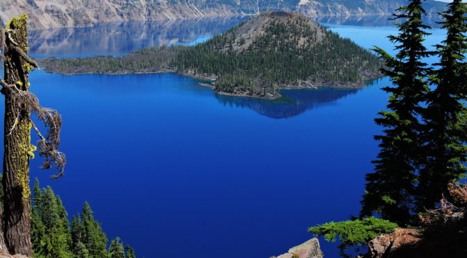
CRATER LAKE NATIONAL PARK.
By the act of Congress approved May 22, 1902 (32 Stat. L., 202), the tract of land bounded on the north by the parallel 430 4′ north latitude, south by 420 48′ north latitude, east by the meridian 1220 west longitude. and west by the meridian 1220 16′ west longitude. having an area of 249 square miles, in the State of Oregon. and including Crater Lake, has been reserved and withdrawn from settlement, occupancy, or sale under the laws of the United States, and dedicated and set apart forever as a public park or pleasure ground for the benefit of the people of the United States. to be known as “Crater Lake National Park.”
The act setting aside these lands for park purposes differed from the acts of Congress creating other national parks in that it provided, among other things. that the reservation should be open “: to the location of mining claims and the working of the same.” It was not believed. however, to be the purpose of this provision to extend the mining laws to the reservation without limitation, but only to authorize t1he location and working of mining claims therein in such manner as not to interfere with or prejudicially affect the general purpose for which the reservation was established. The regulations for the government of the park clearly define the conditions under which this privilege is to be exercised.
About 2,600 persons visited the park during August and September. On May 1,1907, Mr. Will G. Steel, of Portland, Oreg., was authorized to maintain in the park, from that date until November 30, 1907, a transportation service and camping accommodations for tourists. In connection therewith he was also granted a revocable permit to place upon Crater Lake a gasoline launch and rowboats.
The superintendent reports a noticeable increase in the game animals, a number of black bears and a good many deer. which appear to be quite tame, having been seen the past summer.
During August necessary repairs and improvements were made on the trail inside the crater and leading to the waters of Crater Lake. Trails to Glacier Peak and Mount Scott were planned, and that to the latter was opened. The superintendent recommends very strongly the construction of a good wagon road along the Mount Scott trail, in order to make more easily accessible the scenery in the neighborhood of Garfield Peak (elevation 8,175 feet). Applegate Peak (elevation 8,223 feet), Sun Creek, and the pinnacles on Sand Creek. Such a road would afford easy access to Bridal Veil Fall, where the water drops 300 feet from the vertical wall of Applegate Peak, and to the “Pinnacles ” or crater cones in the wonderful Sand Creek Gorge.
At the head of Anna Creek, near the superintendent’s office and residence. there is a superb waterfall which could, at nominal expense, be utilized for lighting all the buildings connected with his headquarters.
In addition to the many permanent improvements which should be made, a very large amount of repair work is necessary in the park each spring owing to the heavy snows and rains and numerous slides from the mountains.
An estimate for an appropriation of $10,845 for the management and improvement of the park during the fiscal year ending June 30, 1909. has been submitted to Congress.
SULLYS HILL NATIONAL PARK.
This reservation, set aside by Executive proclamation. dated June 2, 1904, under the act approved April 27, 1904 (33 Stat. L., 319), contains about 960 acres. It is located on the south shore of Devils Lake, North Dakota, having about 2 miles of shore line, with its western boundary 1 mile east of the Fort Totten Indian School. Inasmuch as no appropriation has been made for the care and protection of this reservation, Mr. Chas. M. Ziebach, in charge of the Indian Industrial School, Fort Totten, N. Da., succeeding Mr. Chas. L. Davis, has been designated as acting superintendent, and required to exercise the necessary supervision and control over the same until other provision can be made for the protection of the park. The tract is well wooded and has an ample supply of water and many rugged hills, among which, on the western boundary, lies what is known as ” Sullys Hill.” In the southwestern part of the park is a small body of water known as “Sweet Water Lake,” west of which the surface is generally level and the soil good.
Approximately, 100 persons camped in the park for three days or more during the past summer, and 300 spent the day in sight-seeing. The acting superintendent renews his recommendations for the fencing of the exposed boundaries of the park, the construction of a dock on the lake shore to accommodate visitors coming by boat, the placing of the roads in proper condition, the construction of the necessary bridges, the walling up of springs, and the clearing away of the undergrowth.
An estimate for an appropriation of $3,000 for the protection and improvement of the park has been submitted to Congress.
PLATT NATIONAL PARK.
By the acts of Congress of July 1, 1902 (32 Stat. L., 641), and April 21, 1904 (33 Stat. L., 220), 629.33 and 218.89 acres, respectively, at the town of Sulphur, Okla. (then Indian Territory), were segregated as the ” Sulphur Springs Reservation,” which designation, by joint resolution approved June 29, 1906, was changed to ” Platt National Park.”
The park, with a total area of 848.22 acres, extends in irregular form a distance of, approximately, 3 miles from northeast to southwest along Rock and Sulphur creeks, including the entire course of the latter, and has a circuit of 9 miles.
Within the park are 33 known mineral and 2 nonmnineral springs. Most of the mineral springs are sulphur springs, although there are bromide, soda, and iron springs, the main groups being as follows: Bromide and Bromide-Sulphur springs in the southwestern part of the park, Beach and Pavilion springs in the northwestern part, and Wilson springs in the southern part. The Antelope and Buffalo springs, nonmineral in character, are situated at the extreme northeastern and upper end of the park, at an elevation of 1,083 feet above sea level, and discharge 5,000,000 gallons daily, which is the entire flow of Sulphur Creek.
On Mav 1, 1907. Albert R. Greene succeeded Joseph F. Swords as superintendent. The park force is composed of a clerk. three park rangers. a forester. and a watchman for Bromide springs.
The revenue derived during the year from temporary leases was inconsiderable, as almost all have been discontinued. The lease of W. L. Townsley to a building for residence purposes was terminated July 1, 1907; and the only concession now held in the park is that granted to A. B. McBride, expiring March 1, 1908, for permission to use a pipe line which has heretofore been laid over the park lands to Rock Creek, for the purpose of taking water therefrom for the operation of a cotton gin outside the park boundaries. This privilege will not be renewed. The balance of revenues available October 30. 1907, for protection, preservation. and improvement of the park was about $27,560.
During the period from June 30, 1906, to October 30, 1907, the expenditures for salaries amounted to $6,300, and for general repairs and improvements to Bromide, Cliff Bromide, Sulphur-Bromide, Taff, Pavilion group, and several other springs, buildings, bridges, fences, etc., for extra-day labor during the summer, and for sewer system surveys, about $5,500.
The office and residence of the superintendent and other buildings, occupied by employees, have been repaired and improved during the past summer. A contract has been entered into for the installation of a water system for the office of the superintendent, at a cost of $669.
The Bland Hotel, which was appraised and paid for by the Government, under the act of April 21, 1904, after the segregation of the lands now included in the park, has several times been offered for sale, but up to the present time no satisfactory offers have been received. The superintendent recommends the dismantling of the building and sale of the material, reserving enough brick, stone, and structural iron for the construction of a barn and forage house in the park.
If the park were enclosed with a fence to keep out trespassing live stock (as many as 5,550 head having been removed in five months during the past summer), the rangers would be able to devote more time to the enforcement of the general regulations of the park. It is estimated that the construction of a suitable barbed-wire fence would cost $2,048.
The superintendent recommends the sale of all that portion of the park north of the south line of Davis avenue bordering on Rock Creek, and comprising approximately 33 acres of land; the installation of telephone service in the residences of all employees for the better organization of the park force in fighting fire and coping with lawlessness; the construction of a path. or burro trail, from Bromide springs to the Sulphur-Bromide and Taft springs, a distance of three fourths of a mile, to save a roundabout walk of 2 miles. which trail it is also stated would materially assist the park administration: the construction of a road adapted for vehicles following the meanders of Sulphur Creek, from East Central Park to Antelope and Buffalo springs; a topographic survey of the park for landscaping and other purposes; the dismantling of the old stone building heretofore used as the superintendent’s residence, and the purchase of driving and draft horses.
There has been submitted for the consideration of the Department resolutions passed by the city council of Sulphur and a number of citizens recommending the inclusion in the park of the ” South Side,” a portion of Sulphur lying south of the park and entirely separated from the main part of the town, which contains approximately 234.83 acres, with an estimated value, for the lands and improvements, of $100.000. In case of favorable action by Congress, the superintendent believes administration would be further aided by the addition of one and a half sections of land, with an area of about 200 acres, south of the ” South Side,” containing delightful scenery and a site for an artificial lake.
Responding to an urgent request of the city of Sulphur, and for the purpose of providing better sanitation for the park and protection of the waters and springs therein, surveys have been made for a sanitary sewer system in the park, with laterals to intersect others connecting with the sewer system of the city. Owing to the topography of the country the drainage and sewage from the city of Sulphur fall into Rock Creek in the park, and at times during floods the waters of the creek rise, overflow the banks, and completely cover adjacent mineral springs. which can not be free from contamination as long as such a condition exists unless very costly improvements are made. The pipes would enter the park at a point opposite First street E.. and continue down Sulphur and Rock creeks to a point below Bromide springs outside of the reservation.
The approximate cost of the work is $30,000, and, as the city of Sulphur would be benefited by the construction of such sewer as much as the Government, it will be only just to require the municipality to bear half the expense, and an estimate, so framed, has been presented to Congress.
During the past summer the city of Sulphur has been granted temporary permission to take water from Sulphur Creek, in the park, a short distance below a cascade known as ” Little Niagara.” for domestic water supply and fire protection. to the extent of 100,000 gallons of water daily, the pumping to be done between 10 o’clock at night and 5 o’clock in the morning, so as not to lessen the flow of the creek during the daytime. The city is likewise required, in connection with the above, to construct a storage reservoir outside the park boundaries with a capacity of 500,000 gallons.
A registry of visitors to Bromide spring shows that in September, 190?, the number was 18,554. and in October, 15,971. As the population of Sulphur is approximately 4,000, it is apparent that many residents make daily visits to this spring, which has gained a reputation for the medicinal qualities of its waters. About 25,000 people visited the park by rail to Sulphur. and about 3,000 persons came by wagon and camped in the park during the year.
Estimates for this reservation have been submitted to Congress as follows: Construction of stone culvert at Sulphur run. near Pavilion springs, $500; construction of park barn for horses and forage. $2,000; care and repair of buildings. fences. bridges, pavilions, and springs, $2,500; and one-half of the cost of construction of a sanitarv sewer system. $15.000; total. $20,000. Other expenses of protection and improvement can be paid from the balance of the park revenues for the next fiscal year.
MESA VERDE NATIONAL PARK.
By act of Congress approved June 29, 1906 (34 Stat. L.. 616), certain tracts of land in Montezuma County. Colo.. adjacent to the Southern Ute Indian Reservation, were reserved and -withdrawn from settlement, entry, sale. or other disposal. and set apart as a public reservation to be known as the ” Mesa Verde National Park.” The area of this tract is 65.5 square miles. or 41.920 acres. and the altitude of the highest point. Point Lookout. is 8.700 feet above –ea level and 2,000 feet above the Montezuma Valley, the southern rim of which follows the park boundary line on the north for miles.
The park is placed under the exclusive control of the Secretary of the Interior, who is authorized to prescribe such rules and regulations and establish such service as he may deem necessary for the care and management of the park, and for the preservation from injury or spoliation of the ruins and other works and relics of prehistoric or primitive man within the limits of the reservation. and to grant permits for the examination, excavation, and other gathering of objects of antiquity by any person or persons deemed properly qualified to conduct the same. provided they are undertaken only for the benefit of some reputable museum, university. college, or other recognized scientific or educational institution, with a view to increasing the knowledge of such objects and aiding the general advancement of archaeological science.
The act also provides that all prehistoric ruins situated within 5 miles of the boundaries of the park, on Indian and public lands not alienated by patent from the ownership of the United States. shall be under the custodianship of the Secretary of the Interior, to be administered by the same service established for the custodianship of the park. The area of this 5-mile strip is about 274 square miles. or 175,360 acres.
The Rio Mancos cuts through the park and abutting 5-mnile strip from northeast to southwest. forming a canyon 1.000 to 2.000 feet deep. On both sides of this gorge. more especially to the vest, narrow lateral canyons of like depth and even more picturesque beauty cut the mesa into shreds. producing successions of high promontories, sculptured ledges. and bold, jagged cliffs. Thee Navaho, Cliff, Moccasin, and Ute are the principal canyons which enter the Mancos from the north. These. with their numerous branches, furnish the labyrinth of cliffs in the high and almost inaccessible recesses of which we find the abandoned homes of the ancient inhabitants. The Fort Lewis. Grass, and Webber Canyons. running into Mancos Canyon from the east, contain many ancient ruins. but are rather less picturesque than those on the west.
Within the park jurisdiction are many notable prehistoric ruins, the cliff dwellings comprising a group of great importance to the study of American archeology.
The principal and most accessible ruins are the Spruce Tree House, located near the head of a draw of Navaho Canyon’. originally containing about 130 rooms, built of dressed stone laid in adobe mortar, with the outside tiers chinked with chips of rock or broken pottery; the Cliff Palace. located about 2 miles east of the Spruce Tree House, in a left branch of the Cliff Canyon, consisting of a group of houses with ruins of 146 rooms. including 20 round kivas. or ceremonial rooms, and a tapering loopholed tower. forming a crescent of about 100 yards from horn to horn. which is reputed to be one of the most famous works of prehistoric man in existence: the Balcony House, a mile east of the Cliff House. in Cliff Canyon. containing about 25 rooms, some of which are in’ almost perfect condition. In each of these villages is an elaborate system of fortifications, with in some cases walls 2.3 feet thick and 20 feet high. watchtowers 30 feet high, and blockhouses pierced with small loopholes for arrows.
These villages and other important ruins. particularly the Spring House, Long House. and Mug House. are located on the Southern Ute Indian Reservation. within the 5-mile strip surrounding the park. -where the park jurisdiction is not exclusive, and it will be more difficult to preserve and protect such objects of antiquity than the ruins on the park lands.
Prior to 1907 no appropriation was made for this park, and for administrative purposes it became necessary to designate the superintendent of the Southern Ute Indian Training and Industrial School at Ignacio. Colo.. as acting superintendent of the park. Upon the recommendation of the Department an appropriation of $;7,500 was made available for the improvement of the park during the present year. and Mr. Hans M. Randolph, of Colorado, was appointed superintendent. Owing to the absence of any buildings for his accommodation on the reservation. his headquarters were established at Mancos. Colo.. on the Rio Grande Southern Railroad. At this point guides and saddle and pack horses can be obtained, and the park is easily accessible.
The sum of $3.000 has been set aside for the construction of roads, trails, and the procuring of water supply in the reservation, and $2.000 for the examination. excavation. and repair of ruins and other evidences of ancient civilization. This latter work is to be conducted under the immediate supervision of Dr. J. Walter Fewkes. of the Smithsonian Institution. -which offered to cooperate with this Department in every way in the prosecution of scientific work in the parl.. A 2+urvev of a practicable road from ‘Mancos in and through the park and the 5-mile strip to the ruins was entered upon by George Mills. United States deputy surveyor, late in the fall and prosecuted until work was stopped by the snow. It will be resumed in the spring. The initial expense of opening the park by the construction of roads and trails to make accessible the manv ruins, and aid in policing and protecting the reservation from forest fires, will aggregate approximately 819.500. and an estimate in that amount has been submitted to Congress.
At the time of the creation of this park there were 360 acres of patented lands. 560 acres in unpatented entries. and lands in sections 16 and 36 granted to the State aggregating 1.280 acres. For administrative purposes these private holdings should be eliminated by Congress making adequate appropriation for the purchase thereof. In the 5-mile limit outside the park boundaries there were patented lands aggregating 31.535.7S acres. unpatented entries aggregating 13,872.16 acres. and lands granted to the State aggregating 4,920 acres. An investigation is no-w being made in the Indian Office to determine the quantity of allotted land in that portion of the Southern Ute Reservation within the )-mile strip.
The act setting aside the land above described as the Mesa Verde National Park is defective in that no provision was made authorizing the Secretary of the Interior to grant privileges or to lease sites to persons for the entertainment and accommodation of tourists traveling therein. or for using the revenues derived from such privileges, leases, etc.. in the eare and management of the park.