
Mount Mazama and Crater Lake: Growth and Destruction of a Cascade Volcano
U.S. Geological Survey and the National Park Service
USGS Fact Sheet 092-02, August 2002
Probing the Depths
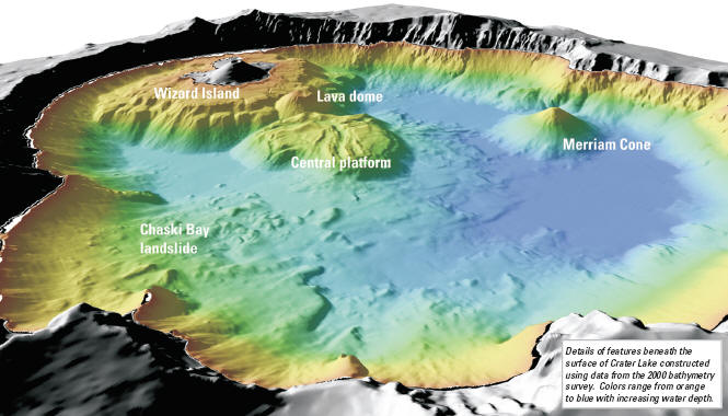 |
| Details of features beneath the surface of Crater Lake constructed using data from the 2000 bathymetry survey. Colors range from orange to blue with increasing water depth. |
For more than 100 years, scientists have marveled at Crater Lake’s great depth and sought to unravel the mysteries hidden beneath its surface. Clarence Dutton of the USGS led the first expedition to determine thedepthofthelakein1886. With a lead weight and piano wire, Dutton’s party made 168 soundings from a rowboat and reported a maximum depth of 1,996 feet (608m). The National Park Service made additional soundings of this type between 1938 and 1940.
It wasn’t until the advent of sonar that the nature of the caldera beneath the lake became clearer. In 1959, the US Coast and Geodetic Survey obtained more than 4,000 echo soundings and provided a more accurate estimate of the maximum depth of Crater Lake 1,932 feet (589 m). Contours of these data revealed the principal features on the floor of Crater Lake – the central platform, Merriam Cone, a small lava dome on the east side of Wizard Island, and the Chaski Bay landslide – for the first time. About the same time, Crater Lake ranger-naturalist C. Hans Nelson collected dredge samples that showed a variety of post-7,700-year eruptive activity. In 1979, Nelson returned to the lake as a USGS marine geologist and used acoustic imaging techniques (like making a CAT scan) of the lake floor to discover that as much as 250 feet (75 m) of sediment had accumulated since caldera collapse. Nelson’s study found that beneath the sediment were many depressions located along the caldera collapse ring fractures. These crater-like structures were probably formed by steam explosions as water began to accumulate within the still-hot debris shortly after the cataclysmic eruption.
A later USGS party mapped areas where large amounts of heat escaped from the lake floor. In 1988 and 1989, scientists from Oregon State University, the National Park Service, and the USGS explored parts of the lake floor with a manned submersible, paying special attention to the warm areas identified earlier. Several dives were devoted to exploring the volcanic features on the lake floor and to sampling caldera-wall outcrops. The exploration with the submersible suggested the need for remapping the lake floor with modern techniques to provide a bathymetric (depth) map for interpreting the postcaldera geologic history and as a base for further study of the lake itself.
The new bathymetric mapping was completed in the summer of 2000 by scientists from the USGS, the National Park Service, the University of New Hampshire, and C&C Technologies. Using a high resolution acoustic mapping system mounted on a special boat, they collected millions of accurately located echo soundings during a 5-day survey. The information gained from this latest survey not only provided a new maximum depth for Crater Lake – 1,949 feet (594 m) – but also resulted in a detailed map of features on the lake floor. By combining the new bathymetric data with past decades of other research, scientists now have the clearest picture yet of events that happened since the massive eruption 7,700 years ago that destroyed Mount Mazama and created Crater Lake.
***previous*** — ***next***