
Historic Resource Study, Crater Lake National Park, Oregon, 1984
VIII. Roads of Crater Lake National Park
B. Entrance Road and Bridges
6. Several New Roads Contemplated
In November 1911 Major Morrow, after two seasons of work, submitted to the Chief of Engineers, U.S.A., his survey report containing maps, plans, and estimates for roads and trails in Crater Lake National Park. [21]
The roads contemplated were an eight-mile one from the south line of the park to headquarters; a seven-mile one from the west line of the park to headquarters; and a five-mile one from headquarters to the rim. On the east side of the lake the engineer determined a route and surveyed a road from the east line of the park to the rim south of Mount Scott, a distance of almost nine miles, following along the south side of Sand Creek and Wheeler Creek via the Pinnacles. A road was also located from the east line north of Mount Scott via Cascade Spring to the rim. Also plotted and surveyed was the central feature of the plan–a rim road running as much as possible along the edge of the caldera and connecting at the park boundary in four places. Projected to be about 1,000 to 2,000 feet above the lake, it would afford unobstructed views of the surrounding country and be one of the grandest scenic roads in the world. [22]
The final report submitted to Congress estimated the cost of construction for these roads at approximately $700,000, which included a sprinkling system to keep down dust that utilized tanks filled by gravity flow placed at suitable spots along the road. The report also recommended that the work be done on a continuing contract arrangement. Steel went to Washington and spent the next winter trying to get the necessary money. In August 1912, $50,000 was obtained to be used toward the improvement of roads from the south and west boundaries of the park to the lake, because these would be the most widely used. But the funds arrived too late for work that season. The following year another $75,000 would be appropriated, making a total of $125,000 available for use in 1913. In 1914, $85,000 was received, and $50,000 in 1915. [23]
For a while yet, however, visitors still had to enter the area via a single-lane, dusty highway that was in reality only a cleared path that barely succeeded in dodging trees in its winding course through the forest. Because of constant use these roads developed such deep ruts that teams were barely able to pass each other. The only work the park was able to perform on them with any regularity involved widening and straightening in those places where trees, shrubs, and logs were far enough away from the road edge to permit such activity. By 1912 there were sixteen bridges and culverts within the park road system, ranging in length from 16 feet to more than 100 feet. All were built of wood and unpainted. [24]
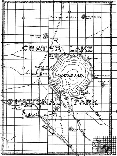
Illustration 18. Map showing new road to rim, 1906. Also shows roads and trails necessary for convenience of visitors and that would aid in park management and protection. From Letters Received by the Office of the Secretary of the Interior Relating to National Parks, 1872-1907, Crater Lake, 362-1905, RG 79 NA.