
Historic Resource Study, Crater Lake National Park, Oregon, 1984
IX. Trails and Campgrounds of Crater Lake National Park
A. Rim Trails
From the time of Crater Lake’s discovery by white men, one of the strongest urges manifested by its many visitors has been to find a way to descend the steep walls bordering the water in order to gaze at close range into its sparkling depths. By 1897 it was recognized that only two places, Eagle Cove and Cleetwood Cove, possessed any kind of beach that could accommodate a trail:
At the lowest parts of the rim at the north end of the Lake, there are several places where good trails could easily be made to the water’s edge, passable even for animals. But at the end nearest the road the only really feasible place to descend and return is at Eagle Cove. The descent can be accomplished here without especial difficulty, and without danger, if caution be observed, in from twenty minutes to half an hour; and the return is double that time. [1]
In 1903 a visitor noted that “on the southern side [of the lake] a steep trail leads downward to the lake, rendered fairly passable by the many, many feet which season after season have gone eagerly down and toiled wearidly back.” [2] In this same year part of Superintendent Arant’s recommendations for improvements in the park, as outlined in his annual report to the secretary of the interior, called for improving the trail leading from the summit of the crater to the water’s edge. He suggested stretching a cable along it to minimize the danger of falling and providing a small house on the crater rim containing a visitor’s register. [3]
In 1907 Arant stated that
There is but one route by which the water of the lake can be reached: it leads from the summit to the water’s edge, and is very steep, crooked, and in many places dangerous–so much so that only the stronger individuals are able to make the descent and ascent, and many are thus deprived of the pleasures of the trip to the water.” [4]
This trail was still considered dangerous in 1914, when it was noted that a visitor could take the rim camp trail “down a depression carved in the rim by the sliding of the avalanches of ages. The trail winds back and forth. . Going down is the most difficult and dangerous, as the descent is steep and there is a risk of slipping.” [5] The superintendent’s report to the secretary of the interior in 1915 lamented the 2,300-foot-long path from Crater Lake Lodge to the lake. It was described as steep and hard to climb and therefore discouraging to many park visitors wanting to fish or boat on the lake. [6] A visitor to the park in the summer of 1916 reported that his family
when about half way to the lake level had to travel over a road of broken ice and snow, and had to cross a steep ravine where the trail was nearly obliterated by water from hanging snow masses. While traversing this ravine a large boulder loosened by the rain and August sun came down from a height several hundred feet above and passed within about three feet of one of my children, and missed striking a young woman further down the slope by a distance of not over a foot; she had to dodge the boulder which was going down at the rate of probably 100 miles an hour. It would have killed any one it struck. [7]
By 1918 a rebuilt 1-1/4-mile trail led from the rim at the lodge to the water’s edge at Eagle Cove. At the base of the trail motor launches could be taken around the lake to Wizard Island and the Phantom Ship. Horses and burros were available for the descent that was described in 1925 as
more than a thousand feet straight down, but by the exceedingly devious trail the distance is much greater. The downward trek is strenuous and the return still more so. . . . In many places the trail was covered by huge snowbanks which had lingered during the whole summer, and these, with the puddles of mud and water, often made considerable detours necessary.” [8]
In 1927 a new zigzag trail was under construction from the rim to the lake’s edge, designed to eliminate the grades and dangers of the old trail. The location of the trailhead was also changed so that hikers would not have to pass through the backyard of the lodge. The trail was to be 8,000 feet long and begin 800 feet west of the Kiser Studio. Whereas the older path had had a narrow bench and grades as high as 28%, the new one would have a minimum bench of six feet and a maximum grade of 15% and be safe for mules, burros, and horses. As it turned out, however, the new trail was not without problems. Because of its unfortunate location, the expense of opening and maintaining the trail in a suitable condition for foot travel each year was out of all proportion to the original cost. Because the trail zigzagged, in several places there were four or five sections of the trail one above the other. The loose sliding formation of the crater wall meant that each spring the trail was almost totally covered with rock and debris fallen from the sides. Maintenance costs involved in removing this material were extremely high as was the possibility of danger to human lives. Visitors often narrowly escaped injury from rolling rocks dislodged by people using the trail above. It was finally decided that relocation and reconstruction of the trail would mean a considerable saving to the government in future years. [9] This trail, completed in 1928, was ultimately abandoned, and then closed in 1959. [10]
The steep trail to Victor Rock just below the Information Bureau (Kiser Studio) was replaced in 1930 by a new trail beginning a few feet west of the building and sloping gently down the rim to Victor Rock where the Sinnott Memorial Building was to be erected. The new wide path would be protected by a stone parapet. [11] A park memorandum dated 1944 mentioned several crater wall trails within the park, formed as a result of employees and visitors alike seeking ways of reaching the shore other than by the one improved 1.6-mile trail from the rim area. These were referred to as “fisherman” trails and included:
1. Kerr Notch Trail–a slide used to reach the lake with a beach at its foot. Trail was steep and little more than a natural drainage from the top to the shore.
2. Bear Trail–upper terminus was located in an old burned-off area just west of the observation area above Cleetwood Cove. Trail was passage for bears going to the lake.
3. Wineglass Trail–years earlier, road contractors ran a pipeline from the rim to the lake to get water for the Wineglass construction camp. Laying of pipe and later use by fishermen from this camp established a well-defined trail up the crater wall.
4. Old Trail to Lake–first trail to lake was located just east of the present lodge. Steep, narrow, and almost completely obliterated by this time. [12]Closed in 1930.
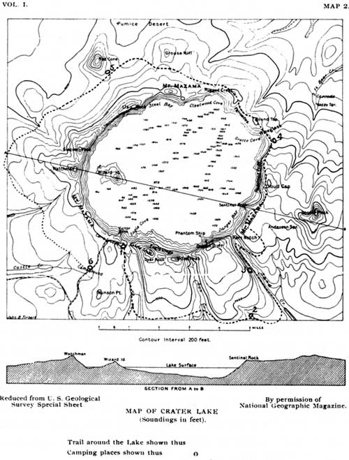
Illustration 22. Trail around Crater Lake, 1897. From Earl Morse Wilbur, “Description of Crater Lake,” Mazama, v. 1, n. 2 (1897).
***previous*** — ***next***