
Clouds, Precipitation, and Snow
By Gregg Fauth
The weather at Crater Lake interests park visitors and employees alike. Everyone has their idea about what is “normal” when it comes to precipitation, whether it is rain or snow. Much of the literature about Crater Lake and its “averages” is dated and therefore inaccurate. Incorporation of recent data into calculations based upon the park’s weather records reveals some significant changes with respect to what we consider average.
Yearly precipitation averages were recalculated on December 31, 1991. Data from 63 years of records shows an annual average for precipitation of 64.31 inches. It is more accurate, however, to use only the totals recorded since 1930, when the weather station was moved from Annie Spring to its present location at Park Headquarters. The average for the 56 years of complete records at headquarters is 66.8 inches. (Data for the years 1930, 1942, 1943, 1944, 1945, and 1946 is not available). The “new” average is more than two inches below the “old” average of 69 inches, which is a figure based upon a 30 year running mean calculated by the U.S. Weather Service.
Yearly snowfall averages were recalculated at the end of the snow year, July 1, 1991. Beginning with the winter of 1930-31, and ending with the 1990-91 winter, the yearly average from accumulated snowfall is 533 inches. (This was obtained from 57 years of data, as the period of 1943-46 is not available). The “new” yearly average is 44.42 feet, significantly below the 600 inch and 50 foot figures that have been used to characterize snowfall at Crater Lake.
One should also be cautious in regard to equating “average” with “normal”. Crater Lake is in southern Oregon, a region whose climate more closely reflects the eccentricities of northern California’s Mediterranean regime than the temperate conditions found north of Diamond Peak. Dry cycles lasting a number of years are par for the park, both in the recent and geologic past. These droughts can be suddenly interrupted by “wet” years which may keep the park snowbound well into July or August. An enormous snowfall during one or several years has the effect of adjusting averages upward of course, sometimes planting a deceptive image to people who have not looked further than the overall average of 533 inches. What is really “normal” is variation.
A “New” Date for Mount Mazama’s Climactic Eruption
By Ron Mastrogiuseppe and Steve Mark
One of the most commonly asked questions at the Park concerns the length of time since Mount Mazama’s climactic eruption, an event which resulted in the creation of the caldera known as Crater Lake. The answer has been given in “radiocarbon years”, usually without explaining what is meant by this term. Geologists have determined the radiocarbon date of Mazama’s eruption to be 6,845 +/- 50 B.P. This is translated as 6,845 radiocarbon years, plus or minus 50 years, before “present” (which has its zero value set at the year 1950, the closest date following publication of the first radiocarbon determinations). Although we all think in terms of calendar years, the calibrated radiocarbon date (which aligns radiocarbon years with calendar years) has generally been overlooked.
Radiocarbon or C-14 dating is based upon a measurement of residual carbon 14 content. Use of this method is limited to specimens containing carbon that have lived within the past 50,000 years. It was developed by Willard F. Libby in the late 1940s and has allowed investigators to better reconstruct prehistoric environments and to place geologic events within a chronological sequence. A C-14 date is estimated from the amount of Carbon 14 present in a sample. The sample’s C-14 content is compared to the percentage of carbon in modern organisms (wood has generally been one of the more reliable types of materials tested). Its content can then be translated into an approximate date because C-14 atoms disintegrate proportionately over time. An estimated date is accompanied by what is called the standard error, or measure of the sample’s reliability. The date for Mazama’s eruption was derived from numerous samples and has been fixed at 6,845 radiocarbon years, plus or minus 50.
Until 1937 it was thought that the Mazama eruption had occurred about 25,000 years ago. Discovery of several archeological sites beneath pumice deposited by the mountain provided conclusive evidence that man was residing in the area at the time of the eruption. The most famous excavations were made by a team led by L.S. Cressman at the Fort Rock Cave, where sandals made of sagebrush bark were found. These and several other types of artifacts were found under a layer of Mazama ash, which serves as an important marker layer in buried soils throughout the northeast fall zone. As a result, the estimated date of the eruption was revised to sometime between 4,000 and 10,000 years ago.
The range of 6,000 years was subsequently refined when three investigators collected a charcoal sample west of the park for radiocarbon dating in 1949. A road cut on Muir Creek along state highway 230 had exposed charred trees embedded in the pumice. Samples were sent to Libby’s laboratory at the University of Michigan which returned a date of 6,453 +/- 250. Libby’s original assumption, however, that the C-14 presence in the Earth’s atmosphere had remained constant through time, was subsequently shown to be invalid. Cosmic ray output by the Sun is variable and thus C-14 present in living organisms had not remained uniform during the 50,000 year time scale.
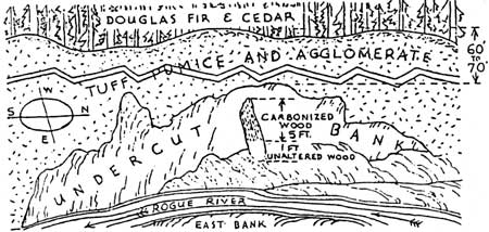
“A Buried Log in Rogue River Tuffs and Agglomerates,” W.D. Smith, Nature Notes, Vol. VII, No. 3, September 1934.
Calibration of the C-14 estimate with a date based on calendar years was made possible when an 8,000 year cross-dated tree ring master chronology was constructed by Wes Ferguson and others of the University of Arizona’s Laboratory of Tree Ring Research. The discovery of record longevity in Great Basin bristlecone (Pinus longaeva) allowed investigators to assign actual calendar year dates to sensitive tree rings in both living and non-living samples. Once the actual calendar dates were known and assigned to a tree ring chronology, it was then possible to subject known decade-aged samples of wood from bristlecone pine to C-14 dating. This was achieved independently by three different C-14 dating laboratories. The data were utilized to draw a graph that plots variation between the C-14 tree ring record and residual C-14 in samples, thus allowing researchers to obtain calibrated values for the past 8,000 years.
The radiocarbon age of 6,845 +/- 50 estimated for Mazama’s eruption can be calibrated to a calendar year date of 7,668 B.P. When an additional 42 years are added (remembering that 1950 is used as the zero point B.P.) to arrive at the 1992 date, 7710 calendar years is the result and will fit within the parameters of statistical reliability. An approximation of 7,700 calendar years is sufficiently close to date Mazama’s eruption, mainly because other variables can affect an exact calculation. One of these is the half-life of Carbon 14, which is 5,730 years. Imagine an hourglass where some of the sand has gone into the bottom half and then compare the ratio of what has gone through the glass with the top half. If we use this analogy to illustrate the decay of radioactive C-14, it would take 5,730 years for half the sand to pass through the glass, and another 5,730 years for half of what remains to pass, and then another 5,730 years for half of that amount to pass, and so forth. Some variation in residual C-14 is expected among samples, so the calibration to calendar years will also be affected.
Some hope that further refinement of the calendar date may occur was raised when the “Mazama Tree” was discovered in 1991. This tree is an eight foot section of a 7,700 year old ponderosa pine, found under 35 feet of ash flow pumice near Chemult, Oregon (some 25 air miles from Crater Lake). It was encased in a tree well created by a fifteen foot deposit of air fall pumice beneath the 35 foot ash flow deposit. The tree was originally approximately two feet in diameter but only the inner one foot diameter was well-preserved. Many “empty” tree wells were found adjacent to the one containing the Mazama Tree, so its presence is something of a mystery and it remains the only uncharred tree remnant so far discovered from the time of Mazama’s climactic eruption.
Investigators hoped that the Mazama Tree’s youngest growth would have been preserved since its burial occurred. If the outer rings were present, a more accurate date for the climactic eruption might have been obtained. Nevertheless, researchers remain optimistic that this can be accomplished by discovering wood within another tree well. If they do, there is a great possibility of obtaining a more exact date for Mount Mazama’s climactic eruption.