
A New Pacific Crest Trail at Crater Lake
The Pacific Crest Trail is a 2,400 mile long trail system that traverses some of the most scenic and remote backcountry wilderness in California, Oregon, and Washington. This very popular trail has an interesting saga and includes Crater Lake National Park as one of its prime destinations.
In 1920, the U.S. Forest Service flagged a trail that extended from Mt. Hood to Crater Lake and dubbed it the Oregon Skyline Trail. By 1928 public interest in a high mountain trail modeled after the “Long Trail of the Appalachians” gave rise to a federally supported endeavor. As a result, the Cascade Crest Trail in Washington became linked with the Oregon Skyline Trail in the 1930s. By 1937 the characteristic Pacific Crest Trail diamond-shaped trail markers extended from the Canadian line to the border with Mexico. In parts of California, however, trail construction was sporadic-sometimes forcing hikers to become masters of improvisation as they forded streams without bridges and followed maps that showed footpaths where none existed. Despite these obstacles, the Pacific Crest Trail is now complete and enjoys continuing public support.
An Alternate Route
Trail users have found that the PCT affords some of the most ecologically diverse and beautiful vistas in the western United States. Even so, the most ardent supporters have long complained that the trail through Crater Lake National Park is one of the weakest links on this nationally important scenic route. It cuts through miles of lodgepole forests and stays several miles away from the rim of Crater Lake. Consequently, many hikers have by-passed this stretch of the PCT and lost hope of an alternate route being provided. After many years of disappointment, however, those hikers are in for an exciting and pleasant surprise. During the summer of 1994 work parties representing the National Park Service and the Friends of Crater Lake completed an eleven mile alternate route that traverses several ecological zones and affords numerous views of Crater Lake from the caldera rim.
The alternate route utilizes existing trails and an abandoned road bed as well as entirely new stretches of trail. Access to the new route from the existing Pacific Crest Trail is gained in two ways. South of the lake, the PCT reaches a junction point with the Dutton Creek Trail. The latter path is part of the new alternate route and by following it on its northerly and direct path to the rim, immediate access to the caldera and adjoining facilities at Rim Village is possible. If you are traveling the PCT from north of Crater Lake, access to the alternate route can be gained from the trailhead junction just south of the Pumice Desert. The new route travels to the east of the trailhead and skirts along the base of Grouse Hill before climbing to the caldera rim just beyond Llao Rock.
Highlights of the New Route
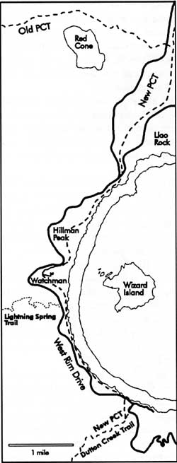 Map by Susan Marvin. |
One of the most pleasant places to relax and get off your feet is at the Dutton Creek junction. This is where Dutton Creek joins other tributaries of Castle Creek, so the area is rich with meadows and streams. As you follow the Dutton Creek Trail north, it winds through grassy areas interspersed with giant conifers. This is a favorite grazing and bedding area for elk and deer. A quiet hiker can usually view these animals in this area, especially at early morning and late afternoon.
Your climb is eased further up the trail by the shade of mountain hemlock, Tsuga mertsensiana,and Shasta red fir, Abies magnifica-procera. This area has been cut by the seasonal streams which run along the length of Dutton Creek, so it is interesting to note how they contribute to this sometimes dry upper portion of the Rogue River Basin. The entire length of Dutton Creek represents a moister, more temperate environment (therefore possessing greater plant and animal diversity) than the demanding conditions evident on the rim.
As the Dutton Creek Trail reaches the Rim Village area, hikers can make use of facilities such as restrooms, a visitor center operated during the summer months, the Sinnott Memorial Overlook, as well as the cafeteria, gift shop, and hotel. The trail route continues along the west side of the caldera and leads to Discovery Point. Interpretive signs point out the discovery of the lake by white miners in 1853 and some of the early history.
Further west, this route encounters the Lightning Spring Trail. At one time a fire control road, the Lightning Spring Trail now serves as an access for stock users who are still confined to the old PCT as they traverse through the park. There is a hitching post for horses, mules, and llamas a quarter mile below this junction so that their users can walk a short distance to see Crater Lake. Beyond the Lightning Spring picnic area, the new PCT follows an old road for five miles to the North Junction. This required no new construction, thereby lessening the impact on fragile soils and vegetation.
As you climb toward 7,500 feet in elevation the Watchman Lookout becomes more apparent. Completed in 1933, this structure is an active fire lookout that is staffed during the summer months. It is open to visitors and provides a great view not only of the lake, but also the surrounding forests and lakes. Look closely and see how many of the major mountains and peaks you can identify.
Once you descend to the Watchman Overlook (sometimes called “the corrals” because of a fence used to protect the remaining vegetation), the new PCT stays above Rim Drive in rounding Hillman Peak. This affords a relatively easy climb of Hillman, which has the distinction of being the rim’s highest point. From here it is a fairly easy descent to the North Junction, so named because this is where the road to Diamond Lake separates from the Rim Drive which continues east and then back to Park Headquarters in Munson Valley.
Near North Junction the trail takes us away from the caldera rim. At this point you will find a desert- like locality with only a sedges and succulents anchoring the soil. This is similar to the Pumice Desert, an area of the park which the PCT skirts on its way north to Mount Thielson. The soils here are deep enough so that you will sink a little with every step. This effect is magnified by the digging and burrowing of rodents, which is experienced if you drop into holes and tunnels made by these creatures.