
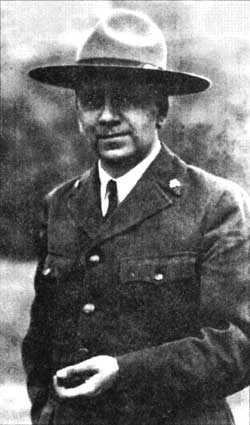
 Ansel F. Hall Ansel F. HallPhoto courtesy of the author. |
At the stops, Mr. Libbey called attention to prominent scenic features such as the perfect symmetry of Wizard island, told about the discovery of the lake, and named the wildflowers and trees. He also pointed out significant geologic formations like the Pumice Desert where volcanic ash lies fifty feet deep, glacial polish and scratches on the rocks at Hillman Peak, the vertical crack filled by the great volcanic dike called Devil’s Backbone, columnar lava at the Wineglass, and the succession of flows exposed in cross-section beneath the rim. Kerr Notch, the last stop, was a fitting climax for the caravan because it afforded an inspiring view of Phantom Ship and a full-circle panorama of the lake framed by the multicolored walls of the caldera. At this point Chief addressed the group, stating that this first trip was experimental and asked for written comments so that the service could be improved. It was continued during the balance of the season with remarkable success, in part because I prepared a log book after that first trip to aid other naturalists in conducting auto caravans.
Heartened by the favorable reception accorded the rim caravans, Chief and Mr. Libbey again set to work to extend the services of the government ranger naturalists in other ways. They spent several days exploring Wizard Island and took extended boat trips on the lake. Finally they announced a thriller — an all-day trip on Crater Lake which included exploration of Wizard Island — all this in the constant company of a ranger naturalist! Chief told me I would be assisting seasonal naturalist Earl Homuth on the first trip.
At 9 a.m. sharp, I met the visitors at the head of the trail to the shore of Crater Lake4and was very much surprised to find that Mr. Homuth had not yet arrived. We waited for several minutes expecting that he would come. (I found out later that he had taken sick at the last minute.) This put me in a quandary. Should I tell these people that the trip had been called off after they had prepared lunches and donned hiking clothes in expectation, or should I lead it myself? It seemed like an audacious thing for me to do — to conduct the first trip inaugurating a new service. Reinforced by the fact that I was in a ranger’s uniform, however, I started down the trail.
I found it easy to interpret the wonderful forest of mountain hemlock, the creeping currant, and the wildflowers that I had come to know so well two years before while writing labels for a nature trail.5 I was much encouraged when I discovered that the visitors were giving me credit for being a real authority. All along, however, I remembered the admonition received from my training in Yellowstone: “Don’t give misinformation.” Occasionally I had to say, “I don’t know.” At the lakeshore, I found that my party had grown considerably larger. There was no chance to back out now.
After boarding the boat, we headed for Wizard Island. The group became most enthusiastic as I shared with it some of the information I had learned from Mr. Libbey when he instructed the park’s naturalist staff at the beginning of the season.
We disembarked at the landing, crossed the jumble of lava blocks, and climbed the steep trail up the cinder slope to the top of the island. We rested at the rim of its crater and ate our lunches. It seemed only natural in this location to talk about the great Mount Mazama which once lifted its summit thousands of feet above us, of the glaciers that gouged out deep valleys along its sides, the mountain’s subsequent destruction, and the comparatively feeble activity which built Wizard Island and two other cones now submerged in the sparkling blue lake. We then walked around the rim of the island’s crater and enjoyed wildflowers blooming within the 100-foot deep crater, as well as the changing panorama of the caldera walls.
After scrambling down the island’s outer cinder slope, we met the boat at the landing and boarded it again for an hour’s voyage on the smooth, azure lake. It was a delightful experience to go around Wizard Island and pass through the “shallows” of Skell Channel before heading northward towards the Devil’s Backbone. Here we paused to gaze at this immense, cleaver-like dike before crossing the lake to Phantom Ship. The time it took to do this helped to impress upon my party that a huge cataclysm caused the destruction of Mount Mazama, and an immense caldera resulted.
At Phantom Ship, the launch pilot called our attention to a vertical cliff which dropped to a depth of more than seventy feet under water. Then we circled this large rock formation with its slender “masts” towering as high as a fourteen-story building. This first trip concluded in the shadow of thousand-foot cliffs as the boat followed the shoreline back to the boat landing. I felt a little guilty about leading the first trip, but Mr. Libbey assured me that I had done a splendid job.
Part Two – Discovery
On July 10, 1931, Park Ranger Ike Davidson discovered a machine on Wizard Island which he loaded onto a government boat and took to the dock at the foot of the caldera wall. With the aid of a pack horse, Ranger Ferdie Hubbard and I carried this machine up the trail to Rim Village the next day. We thought it would be something that W. G. (Will) Steel could identify. He had been hired by the U.S. Geological Survey to measure the depth of the lake in July end august 1886, and he was now serving as the U.S. commissioner.6 He recognized the machine immediately as the one he had built and used for that purpose. Mr. Steel told us, “After the survey was completed, the sounding apparatus was removed from the Cleetwood and cached among the lava blocks on Wizard Island; the boat was sunk in an inlet.”
This sounding apparatus held a special interest to me, especially the two wooden spools or drums mounted on a square axle turned by a hand crank. The square shaft prevented the spools from turning independently of the axle. A leather strap laid across the narrower spool served as a brake while the weighted sounding wire was being raised or lowered in the water. The larger spool was still wound with wire. Mr. Steel showed us the leather tags attached to it at fifty-foot intervals to track the depth of the lake. The sounding apparatus is now part of a permanent exhibit in the Sinnott Memorial Museum, where visitors may see it each summer season when the building is open.
On July 18, Chief and I, with bundles of stakes and a surveying instrument, embarked for Wizard Island. We laid out a new trail to the top on an eight percent grade to replace the steeper trail that the visitors and I had struggled to climb on the first guided boat trip.
Chief wished to do some exploring after we used up our supply of stakes, so he asked me to go back to the landing and bring the rowboat around to West Cape where he would meet me. While skirting the shore, I heard a shout from Chief calling from somewhere on the lava flow: “Drew, come here!” After tying the boat to a rock at the shoreline, I scurried over the lava and found Chief kneeling beside some rusty objects. Upon close examination, we determined that they were window weights made of cast iron. Who had left these on Wizard Island, I wondered. “These could be some of the plummets,” Chief was thinking out loud, “that Mr. Steel used while sounding the lake in 1886.”
Now that Chief had found the plummets, hopefully the Cleetwood would be nearby. We looked around, and over a ridge, was a depression partly filled with water. Several pieces of wood, bleached white by the sun, lay beside the pool. The black lava blocks around the pool were coated with a light-colored substance suggesting that this might have been an inlet six feet deeper when the lake was at a higher level. Looking into the water, we saw what appeared to be a rowboat flattened against the rocky bottom and covered with a thick layer of slime.
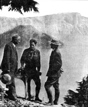 Author with transom, flanked by Will Steel and Ansel Hall. |
With the handle of an oar laying alongside the pool, I poked around in the water looking for something unique that would provide positive identification. Sure enough, deep in the pool and wedged between two rocks, I could make out the form of the transom or stern portion of a rowboat. Barely discernible in the half light were the letters “US.” Now this was a prize worth recovering!
The oar broke while prying and I looked around for a stronger stick, but there were not any to be had. This left only one alternative. After removing my shoes and stockings, I rolled up my breeches and sleeves as far as possible. Upon wading in, I found that I had to stand on a slimy, sloping rock. I reached down into the water, saying to myself, “Gee, it’s deeper than I thought. If I lean over any farther I shall lose my balance. How can I retrieve it?”
I called Chief, who had been busy with the camera during this performance, and he came to my assistance. He set the automatic timer hoping to get a picture. Bracing himself on the rocks, he grabbed my belt while I loosened my prize, raised it out of the water intact, and deposited it onshore. It was well worth it, for all of the letters, forming the initials of the United States Geological Survey, could now be read. This was evidence that we had actually found the hull of the Cleetwood sunk in this cove nearly 45 years ago. A heavy iron ring for mooring was bolted to the transom and it was well preserved, too.
After putting my shoes on again, I shouldered the heavy, slimy, waterlogged transom. Chief carried the window weights. Once these objects had been placed safely in our boat, we rowed across the lake to the foot of the trail to Rim Village. The next day, Mr. Steel confirmed what we had found: the transom is the stern of the Cleetwood and the window weights are the plummets he used when sounding the depth of the lake.
Both the sounding apparatus and the transom are now treasured parts of the park’s museum collection. If Will Steel had not purposely scuttled his “ship,” in 1886, nothing would have survived. For this we owe him a debt of gratitude. Without Ansel Hall’s faith in me, this paper could not have been written. I have tried to convey through its text the feeling of adventure I felt as I participated in these and other learning experiences under Chief’s direction.7
Notes
1 Ansel Hall (1894-1962) had an 18 year career with the NPS which began in 1920 at Yosemite National Park. He rose to become the agency’s chief naturalist three years later.
2 Donald Libbey (1892-1959) served as park naturalist at Crater Lake from 1930 to 1933 and remained with the NPS until his death.
3 Located in what is now the picnic area at Rim Village, this building is sometimes referred to as the “Rim Center.” Evening programs were presented there through the 1988 summer season.
4 Until 1960 the trailhead was located at Rim Village, something which necessitated a descent of 900 feet instead of the 700 foot drop to Cleetwood Cove that visitors have at present.
5 In 1929, as a member of a Boy Scout expedition, l had accompanied Chief and Dr. Harvey Stork (a professor of botany at Carlton College in Northfield, Minnesota-ed.) on a trip to Crater Lake and other national parks. The labels were prepared for the Castle Crest Wildflower Garden near Park Headquarters.
6 William Gladstone Steel (1854-1934) led the campaign to establish Crater Lake National Park, which, after 17 years, met with success in 1902. During his career he was the park’s first concessioner (1907-1912), second superintendent (1913-1916), and first U.S. Commissioner (1916-1934).
7 The original version of this paper was read on May 16, 1992, at a symposium in Ashland, Oregon, celebrating the park’s 90th anniversary.
W. Drew Chick, Jr. retired after a career with the National Park Service and now resides in Lakewood, Colorado.
Why Enter a Sleeping Volcano in a Submarine?
A summary of results and observations from hydrothermal, biological, and geological submersible studies at Crater Lake National Park, 1988-1989.
I was sitting alone in Crater Lake, 600 feet underwater in a small submarine called Deep Rover. I had just completed collecting rock samples along an underwater edge of Wizard Island, and I had 135 pounds of rocks in a basket attached to the front of the submarine. Unknown to me at the time, a couple of O-ring seals were leaking throughout the dive. Water seeping through the seals into the submarine, combined with condensation from my breathing, created an uncomfortable amount of water on the floor. My feet were near the front of the vessel, and as I prepared to start to the surface with the rocks, the submarine tilted forward. As the submarine tipped, the water level at my feet rose rapidly, giving the distinct impression that the submarine was filling with water. Garbled and intermittent communications with the surface crew aggravated the situation. Everyone operated expertly and efficiently; Deep Rover and the rock samples were recovered smoothly. Actual dangers and repairs turned out to be minimal, and the submarine dove again the next day. Nonetheless, I thoroughly reviewed emergency procedures at my first opportunity.
Crater Lake partially fills the caldera of the Mount Mazama Volcano to an elevation of 6,172 feet. Once rising nearly a mile above the rim of the caldera, Mount Mazama experienced a climactic eruption and simultaneous collapse roughly 7,700 years ago. Crater Lake filled with water to nearly its present level within a few hundred years of the collapse. With a maximum depth of 1,932 feet, Crater Lake is the deepest lake in the United States. The lake is well known for its deep blue color and extreme water clarity, and visitors are amazed to see portions of the lake bottom at water depths up to 115 feet on calm days.
Enabling legislation for Crater Lake National Park and the National Park Service (NPS) allow for scientific study if there is no impairment of natural resources. As the fifth oldest national park in the United States, Crater Lake has a long tradition of hosting investigations aimed at obtaining information about the physical, chemical, and biological properties of the lake. Until 1982 lake research had to be done on a sporadic basis, as funding and personnel would allow. Congress then ordered the NPS to begin investigating Crater Lake in a more systematic way, and by 1986 directed that the park’s hydrothermal resources be studied. A geothermal energy company was drilling exploratory wells adjacent to the park boundary, evaluating the potential for geothermal energy development, about the same time these requirements were passed. Although the objectives of the park’s hydrothermal studies were not related to the drilling, undoubtedly this activity provided some political impetus to fund the research. As a result, the one- person submarine, Deep Rover, was flown into the caldera by helicopter to conduct hydrothermal studies in 1988 and 1989. Simultaneously, other studies, also using the submersible, were initiated to explore the distribution of deep-water plants and animals and to assess the early volcanic evolution and the postcaldera volcanic history of Mount Mazama.
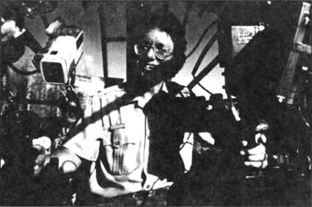 Author in Deep Rover submersible, photo by Mathis Von Hesemans.
Operating a program that utilizes a submersible is a difficult undertaking in the best of settings, but especially challenging in remote areas at high altitude such as Crater Lake. The only access by land to the lake was the steep, one mile-long Cleetwood Cove Trail. Small four-wheel-drive tractors were the primary means of carrying supplies and materials from the top of the caldera to the lake shore on a daily basis. A base camp was established on Wizard Island and over 30,000 pounds of scientific and technical support equipment, including the 7,000-pound Deep Rover, were flown to the island by helicopter. The NPS insisted that no evidence of the operation remain on the island or in the lake after we were done. Researchers were meticulous in this regard and even transported dishwater out of the caldera.
Deep Rover is a highly technical submarine that the NPS, National Geographic Society, and U.S. Geological Survey leased from Can-Dive, Inc., a company based in Vancouver, British Columbia. The vessel is engineered for intuitive operation by its single occupant, who must serve as pilot and scientist. The operator sits in a five inch thick sphere of clear acrylic measuring six feet in diameter. This sphere is attached to two battery pods, each containing ten 12- volt marine batteries. The acrylic sphere opens at the bottom, like a clam shell, allowing the scientist to enter and exit. Mechanical, electrical, hydraulic, and life-support systems are mounted inside and outside of the sphere. Two large manipulator arms are mounted on the front of the submarine and are operated by the pilot inside. A basket mounted below the manipulators is used to stow scientific samples. Cameras, sample bottles, suction samplers, and sophisticated thermometers are other examples of equipment attached to the submarine. Learning how to operateDeep Rover required an intensive one-week training program that included classroom instruction and field work in operation, safety, and emergency response. This ensured that myself and two Oregon State University Oceanographers, Dr. Jack Dymond and Dr. Robert Collier, were ready by the time dives commenced in 1988.
Each dive day began with a trip to the dive site, which usually took one or two hours.Deep Rover was towed behind a research boat in a submersible “tender,” designed specifically for use at Crater Lake. Once all systems were judged to be functional, the operator crawled through the narrow opening into Deep Rover, the submarine hull was sealed, and all outside noise was suddenly muted. Upon being sealed shut, Deep Roverheated up like a mini greenhouse, typically reaching 92° F before descending into the lake un-tethered. With permission to leave the surface, the pilot began the commute to the bottom of Crater Lake.
I had the distinct privilege of conducting 17 dives in Deep Rover. As I slowly sank into the depths of the lake, I was engulfed in blue which eventually turned to darkness. The only sounds in the submarine were the creaking and popping of the hull as it adjusted to the increasing water pressure and the persistent hum of the carbon dioxide scrubbers cleaning the air. The journey to the bottom could take up to 30 minutes, during which time my personal fears were easily extinguished by the intrigue and demands of the work. After reaching the bottom on my dive to the deepest part of Crater Lake, I shut off the scrubbers and instrument lights to better experience the solitude and quiet, and to briefly reflect on being the first person to visit the deepest part of the lake. After several moments, I looked up through the clear acrylic hull and noticed that the dive flag mounted on top of the submarine was visible, and silhouetted against a slightly lighter background. At 1,932 feet in depth my eyes could detect the vague light from the surface, a surprising testament to Crater Lake’s incredible clarity. Yet there was little time for introspection. With less than six hours allowed per dive, I was fully occupied with monitoring electrical and life-support systems, operating the submarine, collecting samples, recording observations on tape and film, and communicating with the surface boat via an underwater wireless telephone. Although the submersible was designed to operate instinctively, many of the tasks I had to perform required extreme concentration and were mentally challenging, physically demanding, and sometimes frustrating.
Most of the lake floor is covered by fine sand colored sediments, and operating the sub there was like flying at night over an uncharted desert. One of the highlights of the research was discovery of bacteria colonies associated with hydrothermal fluids deep in the lake. These colonies form yellow-orange mats which appeared to hang on to or cascade down sediment slopes and rock outcrops. The mats consist of thousands ofGallionella and Leptothrix bacteria, which live on chemicals (primarily reduced iron) in the hydrothermal fluids that slowly enter Crater Lake through the lake sediments. It is unusual that the chemical energy from the fluids allows the colonies to live in darkness on the floor of the lake, independent of photosynthesis, since that process energizes most biological communities on the planet. Temperatures measured inside of the mats were as high as 68° F, whereas ambient water temperature was 38° F. Chemical geothermometry models suggest that source temperatures of 104 to 329° F would account for observed water chemistry and temperatures at the lake-sediment interface.