
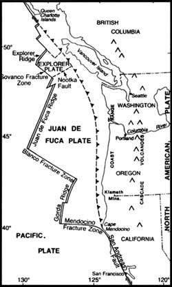
 Plate tectonics relative to the Pacific Northwest. |
Geological settings
At the grandest scale, the High Cascades of Oregon are a product of plate tectonics. As plates of the Earth’s crust subduct off the Oregon coast, crustal material melts and these magmas are found again on the surface as volcanoes. Waldo Lake rests in an area of the High Cascades in a basin composed of basaltic andesite that flowed about 750,000 years ago. It was produced from a group of volcanoes named Waldo Mountain, Cupit Mary Mountain, Fuji Mountain, Mount Ray and The Twins. These lavas however, have been reworked by glacial ice. The area is covered with a fine powder left by ice as it grinds against rock. The glacier that excavated Waldo Lake moved in a northward direction, originating in the highlands between Mount Ray and Fuji Mountain.
Material pushed by a glacier is called a moraine and can sometimes provide barriers for a lake to form. Ice, like water, flows downhill. At the time the Waldo Lake basin was formed, a geologic fault existed just along the west edge of the present lake. The glacier mostly flowed north, but a tongue of ice headed west into the Black Creek drainage as the glacier gained height. It followed the north-south trending fault, marking the western edge of the High Cascade graben (a depression bounded by faults on at least two sides). The glacier did the actual work of excavating the lake, but the fault controlled where that work would take place. If the main glacier had headed into the Black Creek drainage, there would be no separation of the lake basin from the creek drainage and Waldo Lake would not exist. Waldo Lake filled the basin as the glacier melted, suggesting that this water body is 10,000 to 12,000 years old.
Crater Lake is located in the caldera of a collapsed volcano, Mount Mazama. The mountain is also a part of the High Cascades, but in southern Oregon. The overlapping shield and stratovolcanoes that today contain Crater Lake began to be formed about 420,000 years ago. About 7,700 years ago, in a cataclysmic eruption that may have lasted for days, the volcano spewed 50 km3 of ash and pumice into the air covering much of the Pacific Northwest. The magma chamber feeding the eruption was eventually depleted of most of its contents so it could not support itself and collapsed. This feature is termed a caldera. What is unique about this feature is that it contains the deepest caldera lake in the world.
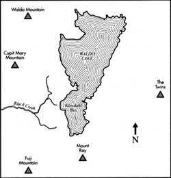 Geographical features in the vicinity of Waldo Lake. |
The collapsed volcano continued to erupt, sealing the floor of the caldera. Two cinder cones were formed on the caldera floor, with one (Merriam Cone) being formed below the lake’s surface and the other (Wizard Island) forming above the surface. The lake began to form within 500 years of the mountain’s collapse. Heat from Mount Mazama’s magma chamber still affects the water of Crater Lake. Not that the heat is enough to alter the surface temperature of the lake, but water circulates down toward this heat reservoir and returns containing chemicals from the geothermal sources located below. Rock on the lake floor is altered by this hot water, and this circulating water chemically alters the lake. This makes Crater Lake fundamentally different from other lakes in the High Cascades.
Physical aspects of the two lakes
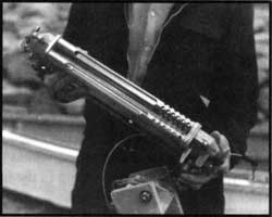 Equipment for measuring light in Crater Lake, 1940. NPS photo. |
Both Waldo Lake and Crater Lake have very small watersheds. Crater Lake occupies a little more than 78 percent of its watershed, meaning that most of the rain and snow input falls directly into the lake from the sky. Waldo Lake occupies about 32 percent of its watershed, suggesting that almost two thirds of the precipitation falling in the Waldo watershed arrives indirectly, by way of land. Waldo Lake would take 30 years to fill with water, given present rainfall and the evaporation rates. That period of filling for Crater Lake would be somewhere between 200 and 300 years. Water falling as rain or snow allows these lakes to exist, but water quality is also affected by the particular characteristics of the respective lake basins.
Water levels of both lakes have remained relatively constant due to three processes: inflow, outflow, and evaporation. The inflow at Crater Lake is almost totally precipitation. In 1985, when the author helped to survey the caldera walls for springs, he was astounded to find 51 surface water inflows into Crater Lake. Few of these springs flow throughout the year, though some include wonderful waterfalls that sometimes drop directly into the lake. Trying to collect water from this type of spring has led to my being ‘soaked to the bone.’ Waldo Lake has no creeks flowing directly into it throughout the year. Ground water, however, flows into the lake thereby offsetting the lake’s outflow.
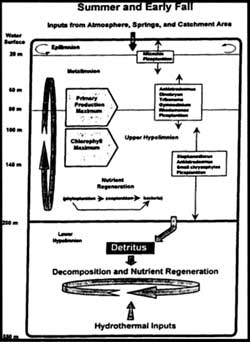 Simple model of the vertical distribution of selected physical, chemical, and biological components of the limnetic zone of Crater Lake. Curved arrows in the epilimnion indicate a zone of circulation and mixing. Graphic courtesy of Gary Larson. |
Swimming in Waldo or Crater Lake is a thrilling experience, largely because of their temperatures. The warmest surface temperature recorded in Crater Lake is 19.2°C, but the maximum some years does not get above 15°C. The same surface temperatures may be measured at Waldo Lake. A lake’s upper stratum near the surface (called the epilimnion) is the warmest layer because lakes absorb heat from the more direct sunlight during summer. Just below this warm layer is a layer of water that changes from the warm surface to the cooler deep water. This transition zone is called the metalimnion, or thermocline. Both lakes share similarities in this zone, one beginning at about 20 meters in depth and extending to roughly 50 meters. There is low heat absorption below 50 meters, so temperatures remain between 4 and 6°C at Waldo. This deep-water zone is termed the hypolimnion and at Crater Lake the temperature remains between 3.5 and 3.7°C. It is in this zone where the two lakes display a marked difference. Some geothermal heat enters Crater Lake from the caldera in which the lake rests, so the water of Crater Lake increases slightly in temperature below 300 meters.
As winter approaches, lakes begin to cool. The cooling of surface water causes this layer to increase in density and sink. The sinking and mixing with deeper water allows chemicals deep in the lake to become available to plants and animals in the shallower parts of the lake, thus a fall ‘bloom’ may occur. As the lakes cool further, ice may form. It is just as unusual for Waldo Lake to not freeze in a winter season as it is for Crater Lake to freeze. The single difference here is depth. Crater Lake is over eight times deeper (using its average depth) than Waldo Lake. This great reservoir of water (and heat) can keep the surface of the lake from freezing. As the surface of a lake cools, it becomes denser—though sinking cool water is offset by rising warmer water. At Crater Lake this can go on all winter. The rising ‘warm’ water at Waldo Lake does not carry the same amount of heat, so the lake will cool below the freezing point of water.
Table I. Comparative Features of Crater Lake and Waldo Lake
| CRATER LAKE | WALDO LAKE | ||||||
| Elevation | 1882m | 6170ft | 1650 | 5410 ft | |||
| Maximum Depth | 589m | 1930ft | 128 m | 420 ft | |||
| Mean Depth | 325m | 1070ft | 39 m | 128 ft | |||
| Surface Area | 53.2 km2 | 20.5 mi2 | 25.5 km2 | 9.85 mi2 | |||
| Volume | 17.3 km3 | 4.15 mi2 | 0.949 km2 | 0.23 mi3 | |||
| Annual Precipitation | 1.71 m | 67.3 in | 1.8 m | 70.9 in | |||
| Water Retention Time (yrs) | 150 | 150 | 30 | 30 | |||
| Length | 9.7 km | 6.0 mi | 9.6 km | 6.0 mi | |||
| Width | 8.2 km | 5.1 mi | 4.3 km | 2.7 mi | |||
| Watershed Area | 14.6 km2 | 5.6 mi2 | 53.5 km2 | 20.7 mi2 | |||
| Watershed (%) | 78.5 | 32.3 | |||||
| Surface Outflow | None | North Fork, Middle Fork, Willamette River | |||||
| Nitrate ion (mg/L) | 1 – 17 (low on surface) | 0.2 | |||||
| Ammonia (mg/L) | 2-4 | 2.4 | |||||
| Total Phosphorus (mg/L) | 22 – 28 | 2.9 | |||||
| Dissolved Phosphorus (mg/L) | 11-15 | 0.9 | |||||
| Conductivity (mS/cm) | 116 | 3.5 | |||||
| Alkalinity (mg/L) | 25 – 31 | 0.58 | |||||
| Sulfate ion (mg/L) | 10 | 0.11 | |||||
The two lakes appear blue because of the interaction of sunlight with the water. A lake will appear colored due to materials suspended in the water (mud, algae), the reflection of sky or clouds, and because of certain colors in the spectrum of sunlight being absorbed by the water. These two lakes have very little suspended material in the water, and so appear clear. Water around the shore appears clear with rocks and sand easily visible. As the water gets deeper, the bottom appears green or blue green the lake absorbs the red, orange, yellow colors of sunlight more readily than the green and blue colors. If the water is more than 60 meters deep, the water appears blue.
Research staff at Crater Lake purchased an underwater spectral irradiometer in 1995. This device measures the light spectrum reaching down to 200 meters in the lake. Red light is quickly absorbed, but the lake transmits blue light of precisely 478 nanometers in wavelength in the deep water. This is the color of Crater Lake that one sees. The irradiometer has not been used in Waldo Lake, but is expected to return similar data. Light in a lake or an ocean eventually becomes so low with increasing depth that one would admit that it was dark. When one investigator took a submarine to a depth of 450 meters on Crater Lake floor, however, he turned all the electric lights off and was able to “see” a slight amount of sunlight from the surface. This is the mark of a lake with incredibly clear water.