
Space does not permit any more detailed description of some of these interesting places. Furthermore, if the reader has access to Nature Notes files of earlier years, he will find an article on the pinnacles by the then Park Naturalist, D. S. Libbey, in Vol. IV No. 3, (September 1931), and one on Llao’s Hallway by W. G. Moody, Acting Park Naturalist, in Vol. VI, No. 2 (July 1933).
We should say a word about the Rogue River and its canyon stretches just by way of contrast to those in the Park since the traveler will be coming or going into the Park at some time by the Medford Road and he will glance down perchance into some of the yawning chasms cut by this fine river. In the upper reaches the Rogue has worked down into much the same character of deposits we find in the other canyons names, but when one gets lower down toward the Medford country he finds the river cutting into solid rock. This rock is a lava, but an older and denser lava than is to be seen at Crater Lake. It is a basalt. One big query arises here in passing — one which is often asked us on duty at the Rim — “Did this lava in the Rogue River canyon flow out of the side of Mt. Mazama when it collapsed?” If this were so, our problem of the destruction of Mt. Mazama would be solved. Unfortunately we must say no. This is an older basalt of Miocene age and is perhaps the equivalent of the Columbia Lava Plateau.
Just outside the Park to the southwest of Crater Lake, the country drops off rapidly into another canyon in this older basalt. The name of this is Red Blanket.
To some, canyons are merely gloomy and forbidding, others find them occasionally attractive, but the geologist finds them useful. The reason for this is that the geologist wants to know what is below the surface and ordinarily he cannot penetrate more than an infinitesimal part of the distance into the interior of the earth by drilling or digging, so when Nature has provided a natural, deep section into the outer crust of the earth, he can examine the materials exposed by this incision and thereby draw much clearer deductions than if he were looking at the surface merely and guessing at what lies beneath. Therefore a geologist, if he is a conscientious worker, will examine carefully every deep cut in the earth. This is the chief interest that such canyons as we have in the Park hold for us who are geologically inclined. Just as a surgeon has often times to make a deep incision into the body to locate the source of trouble or the anatomist makes sections of tissue, so do we rely upon those natural sections. However, in the body of the earth of course, we cannot for the lack of time, means, and power, hope to make artificial incisions into the earth or begin to do what the streams have done for us. We must rely upon every and all such natural sections.
From the foregoing, it is hoped the reader will obtain a respect for our canyons, their interesting features, their beauty, even though at times, awesome, and finally their great utility in deciphering the story of the past in this and all other regions where the pages of certain chapters of the Book of Rocks remain to be cut and deciphered.
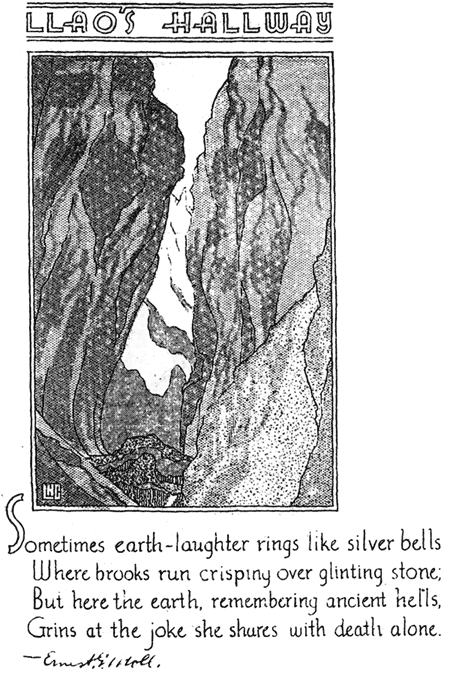
Llao’s Hallway
Sometimes earth-laughter rings like silver bells
Where brooks run crisping over glinting stone;
But here the earth, remembering ancient hells,
Grins at the joke she shares with death alone.
Springs in the Park
By Carl E. Dutton, Ranger-Naturalist
The springs which occur in Crater Lake National Park are individually different as to size and location but their general arrangement is shown by the accompanying sketch map. A consideration of the conditions represented will quickly reveal that four springs lie at elevations below the surface of the lake and they therefore probably represent underground outlets for the seepage which takes place from the lake.
The other springs, which lie at elevations above the surface of the lake, are principally located at the edge of catchment areas covered by pumice. These springs seem to be fed by the downward percolation of rain and melted snow through the sieve-like pumice cover until some non-porous layer diverts the water along the line of flow to the spring.
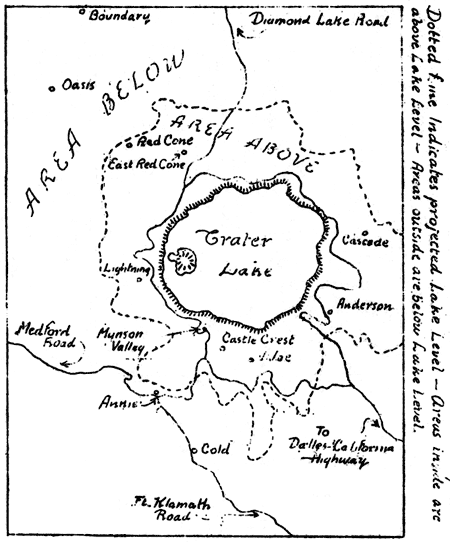
The above descriptions refer to those springs which are named as such on the topographic map of this area. There are, however, also a number of creeks whose headwaters might be considered springs since the water has a rather definite outlet and a well defined flow. The material in this article is limited so as not to include the very numerous occurrences of this type.