Annie Creek Canyon Trail – Crater Lake National Park
Time: 1.25 hours
Difficulty: Moderate
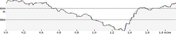
Length: 1.7 mi (2.8 km) loop
Elevation: 5955 – 5955 ft (1815 – 1815 m)
REI Trails Project partners with Crater Lake Institute to produce their trails app. Click the map below, get the app – then come back, we offer more.
- Trailhead coordinates:Latitude: N +42° 52.04 or 42.86739Longitude: W -122° 09.64 or -122.16081 Altitude: 5955 ft (1815 m)
- Highlights: wildflowers; deep, stream-cut canyon, Annie Creek, occasional wildlife
-
Trail Description
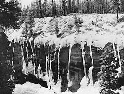 Annie Creek Pinnacles, The Geology of Crater Lake National Park, Oregon by Howell Williams, 1942, photograph by William Schoeb The primary trailhead (the trail can be accessed from several points within the campground) begins behind the park amphitheater. This portion of the trail, and much of the forest surrounding the Annie Creek Canyon, is composed of mountain hemlock, lodgepole pine, and Shasta red fir forest overstory, with the lodgepole pines dominating. The trail leads south along the rim for about a third of a mile before the trail switchbacks down 200 feet to the stream. The trail then moves upstream for approximately a mile before switch-backing back up to the canyon’s west edge and back to the campground. The south end of the trail (within the canyon) reveals the Annie Creek Pinnacles, a very interesting geological feature (see the related links at left).
Some wildflowers and other plants to look for are: Macloskey’s Violet, arrowleaf groundsel, big huckleberry, sulphur flower, Crater Lake currant, broadleaf lupine, American bistort, western mountain ash, Lewis’ monkeyflower, wax currant, common monkeyflower, and many more.
A trail guide (A Trail Guide to Annie Creek by the Natural History Association of Crater Lake NP) is available at the trailhead for $.75 cents or for free if returned when you are finished with the trail.
Trailhead location: Mazama Campground, behind the amphitheater, between the D and E campground loops. The trail is also accessible from several of the other loops. From the south entrance of Crater Lake NP, drive a short distance to Mazama Village. Park at the Mazama Village store parking area and walk to the trailhead.
Nature Note: The creek provides the park’s drinking water. In 1931, one of the world’s largest Western white pines was found in Annie Creek Canyon. It has a circumference of 23 feet and is estimated to be 1,000 years old – Smith Brothers’ Chronological History of Crater Lake National Park
Seasonal Information: Expect the trail to be covered in snow from October to early July, however, conditions vary somewhat from year to year. See Crater Lake Current Conditions for more information.
Annie Spring Canyon Trail Elevation Profile
Related Maps
Digital USGS topographic maps (PDF files) – the following maps are relevant to the Annie Creek Canyon trail. See more Crater Lake Institute online USGS digital maps.
Series Name Year Scale Contour Interval File Size USGS 7.5′ Union Peak 1985 1:24,000 40 ft usgs-union-peak-7.5 USGS 30′ x 60′ Crater Lake 1989 1:100,000 50 m usgs-crater-lake-30-minute USGS 30′ x 60′ Diamond Lake 1978 1:100,000 50 m usgs-diamond-lake-30-minute USGS 1° x 2° Klamath Falls 1970 1:250,000 200 ft usgs-klamath-falls-1-2 USGS 1° x 2° Medford 1976 1:250,000 200 ft usgs-medford-1-2 USGS 1° x 2° Roseburg 1970 1:250,000 200 ft usgs-roseburg-1-2 
Please remember to practice “leave no trace outdoor ethics” when you are out on Crater Lake National Park’s trails…and have fun!
***previous*** — ***next***