
Lightning Spring Trail – Crater Lake National Park
| Difficulty: Moderate
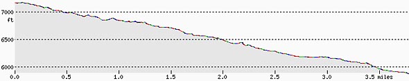
Length: 4 mi (6.4 km) Elevation: 5899* – 7149 ft (1798* – 2179 m) |
Trailhead coordinates:
Latitude: N +42° 56.07 or 42.93461 Longitude: W -122° 10.20 or -122.17014 Altitude: 7149 ft (2179 m) |
*intersection with Pacific Crest Trail
REI Trails Project partners with Crater Lake Institute to produce their trails app. Click the map below, get the app – then come back, we offer more.
Trail Description
This trail is a steady switchbacked descent from the rim of Crater Lake to an intersection with the Pacific Crest Trail. Water is available along the way as are dispersed camping areas.
Mountain hemlock and some Shasta red fir are the primary forest cover for the higher elevation portion of the trail and at the lower elevations, lodgepole pine trees come to dominate. The upper mile and a half skirt the edge of the forest and open pumice fields. The bottom portion of the trail is a more consistent lodgepole pine tree cover with occasional open meadows.
Upon reaching Lightning Spring the trail veers north and then turns west at the base of a steep ridge. This ridge is a part of the Watchman lava flow (see below). The trail follows this wall before turning south to the creek. The trail follows the creek for a half mile before turning northward. The route then turns south, crosses the stream and leaves it heading west.
The next few miles are a steady descent through to the headwaters of Bybee Creek. Before reaching the Pacific Crest Trail the route uses switchbacks to descend to the northern bank of Bybee Creek. The trail parallels the creek for a quarter mile before reaching Bybee Camp and the Pacific Crest Trail.
The trail also serves as access for stock users using the Pacific Crest Trail, as they traverse through the park. There is a hitching post for horses, mules, and llamas a quarter mile below the Rim Drive/Lightning Spring trail junction so their users can walk a short distance to see Crater Lake.
Lightning Spring Trail Profile
Trailhead location: The trailhead is located just a few meters from a gravel parking area immediately adjacent (on the west side of the Rim Drive) of the Rim Drive, approximately 2.5 miles north from the Rim Village.
Historic Note: At one time, this trail was a fire control road, but, has since been converted to a hiking trail.
Nature Note: After a mile of downward switchbacks the trail runs along side of the Watchman lava flow. This massive flow of andesite is two-fifths of a mile wide and extends one and one-quarter miles downhill. It supports an impressive dike on the lake side and the average thickness is between 400 and 500 feet.
Seasonal Information: Expect the trail to be covered in snow from October to early July, however, conditions vary somewhat from year to year. See Crater Lake Current Conditions for more information.
Related Maps
Digital USGS topographic maps (PDF files) – the following maps are relevant to the Lightning Spring trail. See more Crater Lake Institute online USGS digital maps.
| Series | Name | Year | Scale | Contour Interval | File |
| USGS 7.5′ | Crater Lake West | 1985 | 1:24,000 | 40 ft | usgs-crater-lake-west-7.5 |
| USGS 30′ x 60′ | Crater Lake | 1989 | 1:100,000 | 50 m | usgs-crater-lake-30-minute |
| USGS 30′ x 60′ | Diamond Lake | 1978 | 1:100,000 | 50 m | usgs-diamond-lake-30-minute |
| USGS 1° x 2° | Klamath Falls | 1970 | 1:250,000 | 200 ft | usgs-klamath-falls-1-2 |
| USGS 1° x 2° | Medford | 1976 | 1:250,000 | 200 ft | usgs-medford-1-2 |
| USGS 1° x 2° | Roseburg | 1970 | 1:250,000 | 200 ft | usgs-roseburg-1-2 |
|
Please remember to practice “leave no trace outdoor ethics” when you are out on Crater Lake National Park’s trails…and have fun! |