
Sun Notch Viewpoint – Crater Lake National Park
| Time: 25 minutes
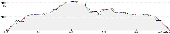
Difficulty: Moderate Length: .5 mi (.8 km) Elevation: 7054 – 7136* ft (2150 – 2175* m) |
Trailhead coordinates:
Latitude: N +42° 54.00 or 42.90003 Longitude: W -122° 05.72 or -122.09546 Altitude: 7054 ft (2150 m) |
| Highlight: views of Phantom Ship; Overlook of Crater Lake and Phantom Ship, scattered wildflowers, dry meadow | |
*at rim
REI Trails Project partners with Crater Lake Institute to produce their trails app. Click the map below, get the app – then come back, we offer more.
Trail Description
|
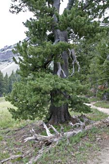
A large, very old whitebark pine from Sun Notch trail, facing west, Photo by Robert Mutch |
This short uphill walk begins in a forest of Mountain Hemlock, then passes uphill through an open pumice meadow to the rim of Crater Lake. The trail then contours along the rim for a short distance, in both directions to the base of the ridge of Applegate Peak to the west and Dutton Cliff ridge to the east. This portion of the rim overlooks the Phantom Ship and provides great views of the Chaski Slide and Dutton Cliff.
The trailhead parking is located on the East Rim Drive between Vidae (west) and Dutton (east) Ridges. Take special care along this portion of the route as steep cliffs lie beneath the track.
Trailhead location: East Rim Drive, 4.4 miles (7.1 km) east of Park Headquarters
Nature Note: Sun Notch lies in an old glacial valley truncated by the collapse of Mt. Mazama.
Seasonal Information: Expect the trail to be covered in snow from October to early July, however, conditions vary somewhat from year to year. See Crater Lake Current Conditions for more information.
Sun Notch Trail Elevation Profile
Related Maps
Digital USGS topographic maps (PDF files) – the following maps are relevant to the Sun Notch Viewpoint Springs trail. See more Crater Lake Institute online USGS digital maps.
| Series | Name | Year | Scale | Contour Interval | File |
| USGS 7.5′ | Crater Lake East | 1985 | 1:24,000 | 40 ft | usgs-crater-lake-east-7.5 |
| USGS 30′ x 60′ | Crater Lake | 1989 | 1:100,000 | 50 m | usgs-crater-lake-30-minute |
| USGS 30′ x 60′ | Diamond Lake | 1978 | 1:100,000 | 50 m | usgs-diamond-lake-30-minute |
| USGS 1° x 2° | Klamath Falls | 1970 | 1:250,000 | 200 ft | usgs-klamath-falls-1-2 |
| USGS 1° x 2° | Medford | 1976 | 1:250,000 | 200 ft | usgs-medford-1-2 |
| USGS 1° x 2° | Roseburg | 1970 | 1:250,000 | 200 ft | usgs-roseburg-1-2 |
|
Please remember to practice “leave no trace outdoor ethics” when you are out on Crater Lake National Park’s trails…and have fun! |