
Two hikes, two views
Herald and News
Klamath Falls, Oregon
September 20, 2004
Two distinctly different trails offers views from the highest and lowest points in Crater Lake National Park.
|
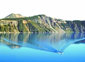
From Mount Scott, Crater Lake looks like a long ribbon of blue floating in the cradle of an elongated caldera. From the lake, Scott appears a twin-tipped sentinel in the blue sky.
Two hikes, two views.
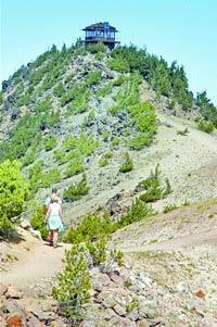
It’s five miles up and down Scott. At an elevation of 8,929 feet, it’s the highest point in Crater Lake National Park. It’s 2.2 miles down, then back up, the trail from the Cleetwood Cove parking area to the lake, where the average surface elevation is 6,173 feet.
Scott is the 10th tallest mountain in Oregon’s Cascades, but it’s a hike possible for everyone from fit youngsters to well-conditioned senior citizens. The elevation gain of 1,030 feet is fairly easily earned, thanks to a well-trod, mostly gradual trail that, except for breath-taking views of the lake, offers little drama.
Crater Lake’s azure waters are the prime sightseeing attraction, but views along the trail and, even better, from the top offer a panorama of Southern Oregon peaks and valleys.
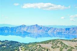 From an elevation of 8,929 feet, the summit of Mt. Scott offers an unrivaled view of the caldera and lake surface nearly 3,000 feet below. From an elevation of 8,929 feet, the summit of Mt. Scott offers an unrivaled view of the caldera and lake surface nearly 3,000 feet below. |
To the west, Union Peak top appears like a knobby horn. To the southwest, Mount McLoughlin offers a wider, different view than normally seen from Klamath Falls. Dominating the north-northeast are the layered slopes of Mount Bailey and the needle-sharp Diamond Peak.
West are the forests of the Rogue Valley, while northwest offers the Pumice Desert, a bald spot on the landscape. Due east is a mix of forests, Yamsay Mountain and the open meadows surrounding Klamath Marsh. But most startling is the view south, where the Klamath Basin lays broad and expansive, with Agency Lake and Upper Klamath Lake.
Closer in, Wizard Island appears like a hat floating in a sea of blue, with The Watchman and Hillman Peak as gatekeepers watching over the island and lake. Llao Rock seems to spread like bird wings petrified in flight.
|
A short while later, after the hike up and down Scott, a quick drive to the Cleetwood Cove trailhead and 1.1-mile walk that drops 654 feet, friends and I were sitting at lake level, below a 30-foot high rocky perch.
We watched as a person stepped to the rock’s edge, spread his arms and flung himself off the rock diving into the lake. Minutes later one of my friends flew like an eagle before gravity plunked him into the lake. After making some graceful swan dives, he politely observed that I hadn’t taken the plunge. So I did.
This particular afternoon only three of us took brief flights off the rock, which is only a short walk from the boat dock near the rest-rooms. Other times I’ve joined lines of people caught up with a contagious zeal to dive or leap into the lake.
Whether diving or swimming, expect to be cool. In late summer water temperatures the upper few feet are allegedly in the 50s, and those readings quickly drop just below the surface.
Remember, too, that the walk out is all uphill. It’s not necessary to completely dry off. That exertion does that quickly enough.
Walking up Scott and adding on a trip to Cleetwood Cover covers a distance of about 7 1/4 miles.
It’s a way of seeing Crater Lake, from top to bottom.
***previous*** — ***next***