
‘Rockin’ in the Klamath Basin
Herald and News
Klamath Falls, Oregon
September 26, 2005
By LEE JUILLERAT
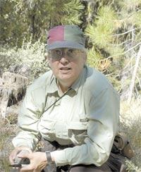
Margi Jenks looks for water by studying rocks.
She’s not a mystic, she’s a geologist. Or maybe she’s both, and a whole lot more.
“I drive around in a pickup truck and beat on rocks,” she says, chuckling at herself. “I’m also a historic explorer of the earth – I like to mess with discovering what’s the genealogy of these hills.”
|
This summer the genealogist/geologist/time-traveler has been tramping through selected areas of the Klamath Basin doing geologic mapping for the Oregon Department of Geology and Mineral Resources.
Jenks did her first tour of field work from April to mid-July, then returned to Portland. Round two started in early September. In mid-November, or whenever the snows push her out, she’ll head back to Portland to compile her findings.
Working mostly by herself, she picks study sites from generalized geologic maps done by the U.S. Geologic Survey in the 1980s and 90s. Her region is vast – spanning from the Oregon-California border north to the Klamath Marsh, and from Gerber Reservoir west to Pelican Butte – and focuses on studying sites that might provide clues to underground water storage.
“Ground water works within a geologic framework. How much water do we have? How much can we pump without drying out the source?,” she asks rhetorically. “Your hydrology modeling is only as good as your geological framework. The water people still need an integrated geological map for the entire Basin.”
Jenks says the best places to drill producing wells are often found by studying the underground geology.
“It’s diagnosis,” Jenks says of her work. “It’s looking at what you can observe and making a considered judgment based on that. A lot of times I can’t figure it out. There are some things you’re never going to know.”
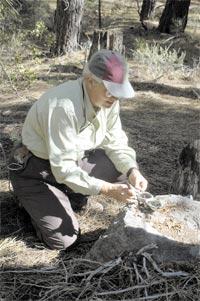
She’s curious about what exists now, and what came before.This day she’s meandering around the Pothole Butte region east of Crater Lake National Park. Using a GPS and intuition, she hikes away from her pickup truck in search of geologic features revealed by USGS maps. At a rock outcrop above a seasonal stream, she tugs a hammer off her belt and whacks at selected stones. After studying the rock and collecting her thoughts, she transfers data from her GPS to a laptop computer, writes in her notebook, and wraps rock samples that will be sent to a laboratory for more study.
“I am fascinated by the history of the earth and how it’s changed over time.”
Her fascination with geology began when she was a history major at McAllister College in St. Paul, Minn.
|
“I was a midwestern kid who’d never heard of this stuff,” she remembers of taking a required-to-graduate science course. “Then I discovered we got to go on field trips.”
Unusually, her field trips have continued.
“The number of women who do what I do and are my age you can count on both hands,” the 53-year-old Jenks says. “It’s fun. I have license to go all over the country.”
During her self-proclaimed “checkered” geology career, which has been interrupted by marriage and motherhood, she did geologic consulting for the timber industry for 12 years. Before and after earning a master’s degree in geology from the University of Idaho, Jenks worked as a private consultant. For three of those years, from 1999 to 2002, she did contract seismic studies in the Klamath Falls area.
She believes that geologic mapping is fundamental in dealing with the Klamath Basin’s ongoing water concerns.
“I don’t have an axe to grind. I would like to see decisions made on the best scientific evidence available. You can’t go around cutting off somebody’s livelihood based on a model that might not be so good,” Jenks says. “You can get water out of clay, but it’s like sipping a milkshake with a cocktail straw.”
During 2001, she voluntarily worked with farmers drilling wells. Of the 24 sites she recommended, 18 met or exceeded expectations, two had moderate water and four were non-producers.
“You look at the landscape now and it’s not like it was 2 or 3 million years ago,” Jenks says of the fascination and frustration of being a time-traveling geologic genealogist. “I want to know how it fits in the bigger picture. It is this great puzzle to figure out – how a landscape came to be the way it is today.”
***previous*** — ***next***