Crater Lake National Park: Trees, wildflowers, dazzling views on trail to Crater Peak
Herald and News
Klamath Falls, Oregon
August 14, 2008
By LEE Juillerat
H&N Regional Editor
Most everyone who visits Crater Lake National Park takes at least a peek at the lake. For hikers, there’s another way to take a peak at Crater Lake.
| If you go …Begin the hike from the Videa Falls picnic area, about 3 miles from park headquarters by East Rim Drive. Turn off Rim Drive to find the picnic area. It’s almost 3 1/2 miles to the summit on a very clearly marked trail with an elevation gain of about 800 feet. Depending on hiking ability, and 1 1/2 to 2 1/2 for the walk back.Take food, water, sunscreen, bug spray, a flower guide and, for the best views from the peak, binoculars. |
Among the park’s lesser hiked trails is one that leads to Crater Peak, a 7,263-foot elevation summit that gets its name from its extinct crater. Crater Peak is located toward the sound end of the park and can be seen while traveling the East Rim Road.
The trailhead for Crater Peak begins at the Videa Falls picnic area off the East Rim Drive, a great spot to stop while driving around the rim with picnic tables and restrooms. A well-signed trailhead leaves no doubt where to begin. It’s slightly less than 3.5 miles to Crater Peak’s summit, an elevation of only about 800 feet that seems higher because of some up-down sections.
Park historian Steve Mark says the trail was realigned in 2001 so that from the trailhead, shortly after passing bubbling Videa Creek, it steeply climbs a series of switchbacks to Videa Ridge. Rock steps were blasted to make the climb easier as the trail parallels the unseen East Rim Road.
For botanists, the early section of the trail is seasonally alive with Lewis monkeyflower, forget-me-nots, lupine, scarlet gila, several varieties of paintbrush, red elderberry, fireweed, sticky currant, bleeding hearts and, closer to the summit, wild strawberries, pussypaws, buckwheat and red columbine.
The trail goes nearly due south through hemlock forests with western white pine. From openings along the ridge, the most dazzling views peer into the depths of Sun Creek, which drops sharply to the east.
Within a half mile of the peak, the trail climbs steadily as it curls southwest, always gaining elevation until bending north, where the surprise is a section of the long-eroded crater. Based on the amount of scat, it’s a favorite place for deer and elk.
The final push to the summit passes through a ghost-like forest of dead whitebark pines, their spiny trunks and branches bleached and bent into irregular shapes. Union Peak, at 7,709 feet in the park’s southwest corner, rises like a horn while Bessie Rock and the Rabbit Ears, both east of the park boundary, in the Rogue River National Forest, are other visible markers.
Crater Peak’s summit is truly breathless. It’s a great place to stop for lunch, and enjoy a 360 degrees view. Most spectacular is a panoramic view south of Agency and Upper Klamath lakes and the Klamath Basin and, closer in, are lush verdant meadows. To the east are portions of the craggy cliffs of the Pinnacles. And while the view north doesn’t include the lake, sections of the lake’s forbidding caldera walls are viewable.
Even if you can’t take a peek at Crater Lake, Crater Peak is a great peak at the park.
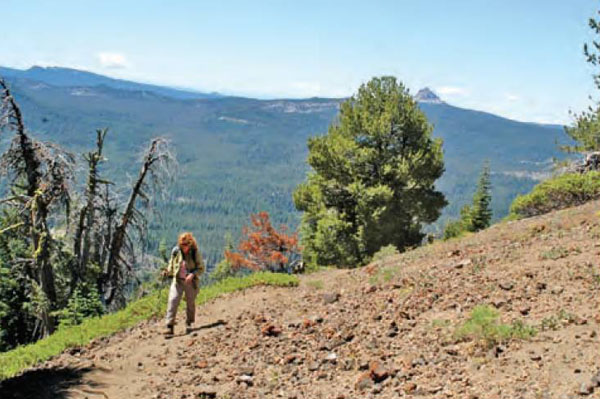 |
| Union Peak and the high Cascades provide a spectacular backdrop for hikers nearing the top of Crater Peak in Crater Lake National Park. H&N photo by Lee Juillerat |
Other pages in this section
- Beetle Outbreak Threatens Park Trees: Researchers Say Global Warming to Blame – Summer/Fall 2008
- Ranger-Guided Snowshoe Walks – November 27, 2008
- New USGS Geologic Map of Mount Mazama and Crater Lake Caldera, Oregon – November 24, 2008
- Crater Lake snow total back to average level – November 5, 2008
- Crater Lake seeks volunteers – November 3, 2008
- Rim Drive at Crater Lake closes for season – November 3, 2008
- Hands and Hoofs: Horse Group helps Crater Lake Ski Patrol mark winter trails – September 18, 2008
- Ski patrol volunteers needed at Crater Lake Park – October 10, 2008
- Parts of wilderness area, Crater Lake park reopen: Cooler weather, rain help firefighters control Middle Fork Fire – October 9, 2008
- Crater Lake facilities closing down: Crater Lake Lodge to close Sunday for the season – October 7, 2008
- Meeting set on Middle Fork Fire – September 23, 2008
- Middle Fork wildfire hits 17,869 then slows down – September 23, 2008
- Weather helps Royce Butte Fire – September 20, 2008
- Fire burns into Crater Lake: Growing Middle Fork fire spreads into remote portion of the park – September 20, 2008
- William “Bill” Hopkins – September 19, 2008
- Middle Fork blaze heads toward Crater Lake – September 19, 2008
- Rattle Fire keeps highway 138 closed for weekend – September 12, 2008
- Hiking trails closed down by wildfire – September 11, 2008
- Family fun day planned at Crater Lake – September 11, 2008
- King of Jordan, ‘Lost’ actor among celebrities at Crater Lake – September 3, 2008
- Remembering Emil, the forgotten Britt: his life was spent in the shadow of his father’s fame – August 24, 2008
- Meissner, Shelton take Crater Lake run – August 10, 2008
- The road to Crater Lake – July 27, 2008
- Crater Lake swimming chilly – July 16, 2008
- Exploring the “Other Half” of Our National Parks: Stargazing Under Protected Dark Skies – June 14, 2008
- Wildfire filling sky with smoke: Fire near Crater Lake is 1,700 acres – September 10, 2008
- Crater Lake: Taking the Plunge – September 4, 2008
- Garfield Peak trail guide – August 28, 2008
- Garfield Peak offers new vantage point to Crater Lake – August 28, 2008
- Plenty of backcountry solitude – August 14, 2008
- Crater Lake boat tours to resume – August 13, 2008
- Crater Lake needs volunteers – August 11, 2008
- Locals Impress: Area runners win 2 short runs – August 10, 2008
- Meissner, Shelton win Crater Lake marathons – August 10, 2008
- Mazama Village to be back to normal – July 23, 2008
- Fire Contained at Crater Lake – July 22, 2008
- 50 spots remain for Crater Lake Rim Runs – July 20, 2008
- Crater Lake; Rim Drive opens today – July 11, 2008
- Crater Lake Rim Run spots going – June 24, 2008
- Crater Lake north entrance opened, but caution urged – June 21, 2008
- Many Crater Lake services open, despite snow – June 10, 2008
- A Tribute to Steve Robinson – Spring, 2008
- Crater Lake’s new boss fulfills a lifelong dream – May 04, 2008
- A Look back at history: Programs focus on history of Southern Oregon – April 25, 2008
- Crater lake has new superintendent: Craig Ackerman will move from the Oregon Caves National Monument – March 5, 2008
- Oregon law could nix proposed water agreement – March 5, 2008
- Crater Lake contaminated, new study suggests – February 28, 2008
- Airborne Contaminants Found in Western U.S. and Alaskan National Parks – February 28, 2008
- Airborne Contaminants Study Released Measurable Levels Detected in Twenty Western National Parks – February 26, 2008
- What to do: Crater Lake rangers guide free hikes – February 23, 2008
- Crater Lake story will air – February 9, 2008
- Park rangers undaunted by weather – February 8, 2008
- TV crew makes trek to Crater Lake’s rim – February 8, 2008
- ODOT worker hurt when tree crushes pickup truck – February 4, 2008
- TV crew headed to Crater Lake – February 6, 2008
- Park Ranger Ken Hay Retires – January 28, 2008
- Crater Lake offers 90-minute winter tours: Park rangers lead free treks in park on Saturdays – January 24, 2008
- Laurels go to retired Crater Lake official: Dinner given for former park superintendent Chuck Lundy – January 21, 2008
