
Monitoring ParkScapes Over Time: Plant Succession on the Pumice Desert, Crater Lake National Park
By Elizabeth E. Horn, ParkScience, Vol. 22, No. 1, Fall 2003
The Pumice Desert is a conspicuous natural feature in Crater Lake National Park, Oregon. Contrasting sharply with the surrounding lodgepole pine (Pinus contorta) forests, the Pumice Desert is a rather barren-appearing, flat area of about 5.5 square miles (14.2 square kilometers). The Pumice Desert is about 4 miles north of the Rim Drive on the north entrance road.
Park staff were unsure of the explanation for this opening along the park’s north entrance road. Why was plant succession so slow? What were the factors that kept and maintained this opening? What kept lodgepole pine from colonizing the area in greater numbers? Specific answers are hard to find. Studies showed many factors were interacting to hinder plant succession, including gopher activity, infertile soils, soil temperatures, and seed source. Few pine seedlings were found during field work, suggesting a problem with recruitment. An interpretive sign along the park roadway explains that the ancient Mount Mazama had massive glaciers along its flanks. One of these glaciers carved a deep valley north from the summit, extending several miles beyond the park boundary. After the glaciers melted, glowing avalanches of gaseous material filled the valleys and depressions around Mt. Mazama. The porous pumice soil was probably more than 100 feet deep in the valley now occupied by the Pumice Desert.
As a graduate student and seasonal ranger-naturalist during the summer of 1964-1965, I studied this desert area as part of my master’s thesis. The study was initiated in 1965 to (1) describe the existing vegetation, (2) measure selected environmental factors such as air and soil temperature, evaporation stress, precipitation, soil nutrients and soil moisture; and (3) establish photo points so that any changes in vegetation could be tracked over the years.
Study methods
Vegetation was sampled with 22 line transects, each 200 feet (61 meters) in length and 10.9 feet (3.3 meters) wide for a total transect area of 0.1 acre (0.04 hectare). Coverage data were taken on the basis of line interceptions. Density and frequency data were gathered within the transect, and coverage data were measured on the basis of interceptions along the centerline. Because only three lodgepole pines were found in the 22 line strips, another 100-acre (40.5-hectare) plot was set up to measure only the lodgepole pine. The lodgepoles were measured by height and basal diameter; they were not big enough for diameter breast height measurements.
Summer climate data were gathered using a recording hygrothermograph, rainfall was measured with a totalizing gage, and environmental evaporative stress was estimated with Livingston black and white bulb atmometer spheres. Soil samples were taken to a testing laboratory.
Nine of the line transects were randomly selected as permanent plots, although I purposefully included examples of the three microhabitats in the area (north and south-facing slopes and the flat central wash with fine gravels). Each end was marked with an iron rod. The large tree plot was also marked for future reference. Photos were taken from each end of the strip plots and from each corner of the tree plot.
Findings in 1965
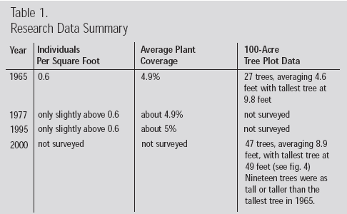
The 1965 research showed only 14 species of plants growing within the plots. The park is home to nearly 600 plant species, so the flora of the Pumice Desert is quite sparse by comparison, with only 0.6 individuals per square foot and plant coverage averaging 4.9%. Most plants demonstrated one or more morphological characteristics typical of alpine or desert plants. The 100-acre (40.5-hectare) tree plot contained 27 trees with an average height of 4.6 feet (1.4 meters). The tallest was 9.8 feet tall (3.0 meters).
The pumice soils were generally deficient in nutrients and in organic matter. However, they were not significantly different from other pumice soils in central Oregon where there was more growth than in the Crater Lake Pumice Desert. Reasons for these differences are yet to be studied.Climate data showed air temperatures that were both higher and lower than those recorded at park headquarters. The lack of vegetation probably contributed to these differences. Most significant were the high soil temperatures recorded on sunny days. For instance, when air temperature over a six-hour period did not exceed 83oF (28oC), the surface soil temperature averaged 102oF (39oC).
Plot visits in 1977, 1995, and 2000
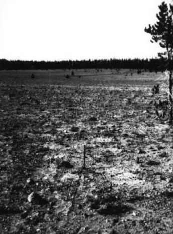
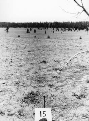
Figure 1. Vegetation plot in 1965 (top photo) with one lodgepole pine along its edge. Right-hand photo taken in 1995 showed the tree was dead; a few limbs protrude into the photo. Background shows increased number of trees invading from the northern forest edge.
I revisited and surveyed the vegetation in the permanently marked line strips in 1977 and in 1995. Photos were taken from each end of the plots (see fig.1). The results were fairly consistent each year. Although the 1977 tallies were slightly higher than in 1965 or 1995, the percent cover for each year remained about 4.9% (see table 1). Although individual plant species numbers fluctuated somewhat from year to year, the totals remained fairly constant.
In 2000 the trees in the 100-acre tree plot had increased dramatically, from 27 to 47 in number (see figs. 2 and 3). The average height was 8.9 feet (2.7 meters) tall, a substantial increase in size showing good growth over the interim 35 years. The tallest tree was 49 feet (14.9 meters). Nineteen of the trees measured in 2000 were as tall or
taller than the tallest 1965 tree (see fig. 4). Many of the trees showed distinctive mounding at the base, caused either by wind deposition or gopher activity. More than half the trees had multiple stems or trunks, a characteristic not uncommon in harsh environments. What triggered the successional processes after what appeared to be a long time of low productivity is unknown. One possibility is a general warming of the climate, which would favor a longer growing season.
Effect of visitors on vegetation—an interesting side story
A small vehicle turnout with an interpretive sign had been established in1958 along the north entrance road at the south edge of the Pumice Desert. Visitors had walked into the Pumice Desert from the interpretive pullout, and the effect was obvious within an area of about 100 yards (91.4 meters) from the pullout. To quantify this, a sampling strip was laid out in 1965 and the results were compared to the other plots. The total number of individuals counted in this single plot was 1,037 compared with an average of 2,580 individuals in the other 1965 plots. The cover was 1.6% compared with the 4.9% average of the other plots. This reduction in plant cover occurred during a short seven-year period (1958–1965). This data collection was only done in 1965.
Park and researcher contributions
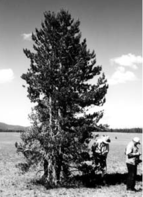
Figure 2. Typical multi-stemmed lodgepole pine photographed in the summer of 2000. This tree has nine trunks and measured 19 feet in height.
The project was very much a joint effort from its 1965 beginning. Crater Lake managers and staff provided time and transportation for doing the research. Purdue University provided the climate and recording equipment. However, the single most important ingredient was the participation of park staff. Park biologist Richard Brown was the enthusiastic instigator. Staff donated their time off to help tabulate plants on the plots and make climate and soil recordings. The park had a darkroom, and several staff developed photos of the plots. The maintenance staff made the iron rods to mark the plots and devised a coding system for their identification. It became everyone’s project and provided a focus for the developing camaraderie among the staff.
The case for long-range vegetation studies
Park settings are ideal places for long-range vegetation studies. The 1965 study provided a snapshot in time. It told what was on the Pumice Desert during that particular summer. But it was a static picture. Long-range monitoring has the following advantages:
1. Once a study is set up, it can be monitored with little additional effort or cost. Each additional visit to the site involved about five days each for me and a few colleagues.
2. Photo points can speak volumes even if vegetation is not tabulated. Photo points, once established, are usually not difficult to find again.
3. Park areas are generally not disturbed by human-made intrusions. The vegetation and the landscape are for the most part protected from unnecessary human-caused impacts. However, in this study, there were two artificial intrusions on the Pumice Desert. The first was the route of the Pacific Crest National Scenic Trail. Records show the trail was probably routed on an old fire road through the Pumice Desert in 1929. The trail was moved to a route east of the Pumice Desert in 1976 to line up with the trail around Mt. Thielson north of the park and to reduce plant damage in the Pumice Desert. However, the track and the vegetation changes can still be seen along the old route. The second intrusion is the trampling that has occurred near the interpretive sign. Although the changes near the interpretive sign were not part of the study, both examples are valuable because they illustrate the impact that can occur on delicate plant communities.
4. The data from the 1965 tree plot showed that few trees had populated the Pumice Desert. The 1977 and 1995 vegetation plot data showed little change in the average plant cover or individuals per square foot. Expectations would be that there was also little change in the tree plot data. However, the 2000 data on the tree plot showed that succession was indeed proceeding. Had we not set up and followed up on an additional plot to only monitor tree numbers, we would have assumed that little had changed on the Pumice Desert. We had two sets of data (tree plot and vegetation plot), and if we had stopped with only one set, we would not have had a complete picture. Why the tree numbers have increased while the vegetative numbers remained fairly constant is another interesting question. The answer may be as simple as normal population dynamics, which would be more apparent in the shorter-lived herbaceous plants. Spring moisture, for example, would have a definite influence on the survival of seedling herbaceous plants with shallow root systems. Patience and thoroughness are necessities for long-range monitoring.
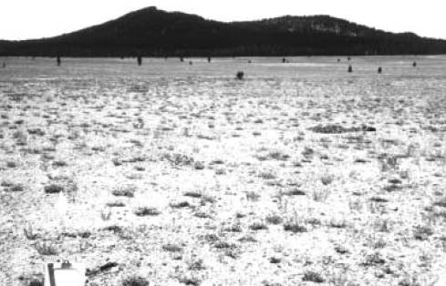
Figure 4. View from northwest corner of the tree plot, lower photo taken in 1965; upper photo taken in 2000. Note the increased number of trees in the middle ground in the 2000 photo. Note the large areas of barren ground. Pocket gopher mounds show in the foreground of the 1965 photo.
Summary
Research during the past 35 years has shown that many interacting factors undoubtedly combine to slow plant succession on the Pumice Desert, including climate, short growing seasons, sterile soils, hot soil temperature in summer affecting seedling survival, and rodent or gopher activity that aerated and mixed the soils (a positive thing) but also negatively affected the vegetation when they ate the roots. However, the number of trees that have become established on the 100-acre tree plot has increased by 75% between 1965 and 2000. Eventually, as succession proceeds, conditions will become more hospitable for new seedlings. The plots established in 1965 allow continued monitoring of this progress. The surrounding lodgepole pine will eventually infiltrate the area and the Pumice Desert will cease to exist.
I greatly appreciate the assistance of the staff of Crater Lake National Park in the many stages of this research. I also would like to acknowledge the assistance of plant ecologists Fred Hall and William Hopkins in resurveying the vegetation plots and the cheerful assistance of Kirk M. Horn throughout.
References
Applegate, E. 1939. Plants of Crater Lake National Park. American Midland Naturalist 22(2): 225–314.
Horn, E. M. 1968. Ecology of the Pumice Desert. Northwest Science 42(4):141–149.
Sternes, G. L. 1963. Climate of Crater Lake National Park. Crater Lake Natural History Association, Crater Lake, Oregon.
Williams, H. 1942. The Geology of Crater Lake National Park, Oregon. Carnegie Institution of Washington Publication 540,Washington, D.C.
About the author
Elizabeth L. Horn holds a B.A. from Valparaiso University and an M.S. from Purdue University and began this research as a seasonal ranger-naturalist at Crater Lake National Park from 1964–1965. She retired from a 30-year career with the U.S. Forest Service and now resides in West Yellowstone, Montana, and can be reached at khcritters@aol.com.
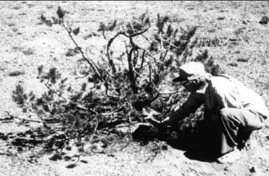
Figure 3. Author examines base of multi-stemmed, bushy lodgepole pine. Multiple trunks are not uncommon in harsh environments. There could be several causes. Genetics can create a predisposition for multiple stems, but the surrounding forest did not exhibit multiple stems. Rodent seed caches could result in multiple stems. However, examination of seedlings under 6 inches in height determined that seedlings have single stems, while slightly larger bushy-shaped trees clearly showed apical stem damage. This would release the side stems to grow upright. The damage could be caused by wind-borne pumice abrasion, gophers, or winter drying from low snow levels. In some cases, gopher gnawings were clearly present. Although the researchers have some guesses, the cause of this phenomenon would be an interesting future study.