
Historic Resource Study, Crater Lake National Park, Oregon, 1984
V. Geological and Biological Information on Crater Lake Area
B. Formation of Lake
During Mazama’s last long period of dormancy, magma had been crystallizing in feeder tubes deep inside the mountain, thereby preventing the escape of gases. The consequent mounting pressure began to blast cracks in the roof of the magma chamber five or six miles underground, a process that would soon allow its fiery contents to escape.
Advance notice of the final gigantic eruption of the mountain came in the form of violent earthquakes and explosions, precipitating enormous clouds of gas and steam, hurled up amid smoke and pumice, that condensed into billowing thunderclouds Columns of dust, ash, and bits of rock blocked out the sun for weeks, while pumice dust whitened the landscape for 600 miles around. This action was followed by a lull of several weeks before the explosions resumed again, emitting yet more tall clouds of steam. Then pumice again began to boil, and small fragments began shooting upward through vents already widened by earlier outbursts. As this column of molten rock rose in the throat of the volcano, it gathered speed until it finally boiled over the rim in a glowing avalanche of expanding gases and pumice that, at exceedingly high temperatures and speeds, raced down the slopes and over the surrounding country for a distance of more than thirty-three miles, crushing and suffocating every form of life in its path. Blocks of pumice as large as fourteen feet in diameter have been found as far as Chemult, twenty-five miles northeast of the lake. Mount Mazama’s final eruption lasted only a comparatively short time:
The probability is that the whole eruptive episode was short-lived and that explosions, if not actually continuous, followed each other at short intervals.[5]
In the early years of study of this area, the primary events in Crater Lake’s violent birth were pieced together by patient sifting of the available geological evidence: glacial, scars, pumice deposits, and lava flows. In recent years, carbon-14 dating has provided more precise information. Radioactive carbon in the charcoal of trees, charred and buried under lava and pumice, date the eruption at between 6,600 and 7,100 years ago, or around 4,600 B.C. The first theories on Crater Lake’s formation suggested that Mazama s sudden and thunderous explosion had scattered the top of the mountain hundreds of miles in every direction, leaving a fiery crater that eventually cooled and filled with water from rain and melting snow. On December 18, 1901, during a presidential address before the Geological Society of Washington, Joseph S. Diller, Chief Geologist of the United States Geological Survey, proposed instead a theory of subsidence. His field reports were published the next year as a USGS professional paper, and the theory gained general acceptance. [6]
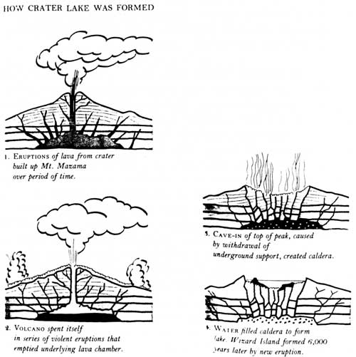
Illustration 1. From National Parks of the West, p. 71.
Diller’s main premise was that great quantities of molten rock drained away through subterranean passages, thus weakening the peak’s support and causing its collapse. For days following Mazama’s final explosion, long fissures continued to open beneath the volcano due to uninterrupted underground activity. Through these additional minor eruptions and expulsions and the gradual draining away of magma through underground chambers, the mountain’s energy spent itself, leaving the peak a heavy shell hanging over an empty pocket. Shaken by the continued violence and deprived of the molten magma core that had supported it, the top of the mountain, within probably only a few days, collapsed with a roar that must have been earth-shattering. When the dust and rubble cleared, the upper mile of the mountain was gone. All that remained of mighty Mount Mazama was a hollow base. Thus was the great basin that would become Crater Lake born, as a huge pit or caldera, more than five miles across and 4,000 feet deep, rimmed by tall glaciated precipices.
Quiet reigned now for a short time, interrupted occasionally by lava bursting through the fractured floor of the basin. Such activity near the north wall resulted in 1,300-foot-high Merriam Cone, whose tip is almost 500 feet below the surface of the lake. In time the floor solidified, only to be cracked by another eruption in the southwest corner that resulted in a smaller cone, now known as Wizard Island, rising 763 feet above the water level. Gradually these new cinder cones and lava fields partially refilled the great pit. The first rain- and snowfalls into the basin were probably turned to steam by the boiling mud and hot rocks on its floor. But as volcanic activity ceased and the mountain cooled, and as annual precipitation far exceeded the amount of water lost by evaporation and seepage, input from rain and melting snow began to accumulate, causing the water level to rise and ultimately resulting in a broad lake that filled the caldera up to about half its depth. Because all outlets and inlets had been plugged by lava flows during the eruption, the water level has remained constant through the years except for seasonal variations or drops in the levels of annual precipitation. A certain amount of water disappears through underground seepage. [7]
***previous*** — ***next***