
Historic Resource Study, Crater Lake National Park, Oregon, 1984
VIII. Roads of Crater Lake National Park
B. Entrance Road and Bridges
9. Plans Made for Second Rim Road
By the fall of 1928 the rim area could be reached by a new oiled road from the west boundary that had replaced the old hazardous route with its 11% grades with a new one containing a maximum of 6-1/2% grades. At the rim a new oiled road was completed distributing traffic to the new cafeteria and cabin group, to the campground, and to the lodge at the opposite end of a half-mile-long plaza. On each side of the boulevard area was an eighteen-foot parking strip to accommodate several hundred vehicles and along the edge of the crater a wide asphalt promenade for pedestrians had been constructed.[38]
The next large undertaking of the U.S. Bureau of Public Roads within the park would be construction, beginning in 1931, of a modern standard-grade rim road to reroute the existing one, which was passable but which did not closely follow the lake rim. Despite its steep grades, sharp curves, and dusty condition, it had been used by many park visitors. While location surveys were underway for the new road in 1929, two projects were started on the east entrance road to the park. The Sand Creek park boundary project, 4-2/10 miles long, was an approach road from The Dalles-California Highway to the east entrance of the park, while the Lost Creek project consisted of two miles of road work within the park. These 6-2/10 miles of road at the east entrance outside and inside the park had been surfaced. The 1-3/10 miles of grading from the end of the surfacing project to the Lost Creek ranger station were to be finished that season. This road served as a connecting link between the main roads through the park and The Dalles-California Highway to Bend, Oregon, the southern end of the new Willamette Highway between California and the Willamette Valley. A surfaced parking place was constructed this year at the Pinnacles. [39]
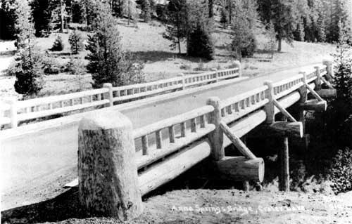
Illustration 20. Annie Spring bridge, 1929. Courtesy Southern Oregon Historical Society.
By the first of May 1931, bids were being called for to grade the first six miles of the new rim road from the lodge area around the west side of the lake to the North Entrance ranger station at the Diamond Lake junction. Work was begun in June using three gasoline power shovels, one steam shovel, fifteen trucks, several air compressors, and other equipment. Approximately 120 men were employed in 1931 for a period of five months. A new south side route now brought tourists to a vantage point at Sun Notch. Surveys were also completed for the balance of the route north to Diamond Lake and for connections down Union Creek to the Medford road and east to The Dalles-California Highway. [40] In July construction on three projects was reported delayed because of the excessive snowfall of the previous winter. A Portland construction company was preparing to complete the grading of the first six-mile unit of the new rim road begun the previous year. One hundred laborers would be at work on two eight-hour shifts to assure completion that year.
Another construction company had fifty men working on the portion of the rim road leading from a point near Lost Creek to Kerr Notch, a distance of 4-1/2 miles necessitating clearing of timber and grading, a project also begun the year before and expected to be completed in the fall. A third company was working on the Diamond Lake road in the park with fifty men completing a 1931 project of eight miles. [41] More than 100 men were again employed on the rim road for four months in 1932, and it was projected that the road would be extended to the Wineglass, in 1933 to Kerr Notch, and be completed in 1934 with the construction from Kerr Notch down Sand Creek to Lost Creek, then up to Sun Notch, down to park headquarters, and up to the rim. [42]
In 1933 only two months’ labor was possible on the rim road as a result of deep snowdrifts. By July four contracts for road construction in and near the park were getting underway. Laborers were being employed through the relief agencies of Klamath and Jackson counties. Because of snowdrifts twenty-five feet deep that had to be removed, work could not begin until August 15. During blasting operations in 1933 on the rim roadway, traffic around the rim was permitted. Projects to be accomplished during the summer included grading of the next eight-mile unit of the rim road from the end of the previous contract at the North Entrance ranger station and fourteen miles of surfacing from the Rim Village area to the north park boundary (final grading of this section was completed, in 1935); grading of the next four-mile unit on the east rim, begun and completed in the 1933 season; 5-1/2 miles of grading from the boundary to the southern end of Diamond Lake outside the park; surfacing of 4-1/2 miles of the east entrance road to Kerr Notch; and grading eighteen miles of the Union Creek entrance to Diamond Lake, continuing from where the five miles of grading was completed the previous year. [43]
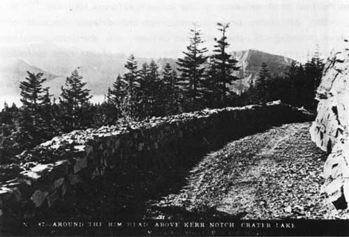
Illustration 21. Rim drive above Kerr Notch. Courtesy Southern Oregon Historical Society.
By 1934 the surfacing of the lodge-North Entrance ranger station section of the rim road was completed; the Diamond Lake route from the north entrance to the park boundary was to be oiled in 1935. Construction of the second unit of the rim road, from the north entrance to the Wineglass, was more than 50% complete. The third unit of grading, from the Wineglass to Cloudcap, was completed in 1934, leaving for future work the distance from Lost Creek to Government Camp. [44] In addition to major road projects, cut-stone curbing was placed around all driveways in the Government Camp area that year, and at the rim similar curbing was placed around the lodge and part way from that structure to the cafeteria. [45]
The route of the rim road had to be changed to some extent to reduce the grades in reaching Cloudcap, the highest point on the road. The next four miles of grading were to be completed during the 1936 season, bringing the rim road to Kerr Notch on the east side of the lake, leaving only nine miles of construction not yet started. A contract for four miles of the work, during which the road would diverge from the old bed and be built higher on the slopes, was to be let in early 1936; the remaining five miles to park headquarters would be left unchanged from the present route. Surfacing activities followed grading on the west rim, and were to be accomplished on a stretch of the rim road from the North Entrance ranger station to Cloudcap. [46] It was still hoped that the rim road would be completed by or during the 1939 season.
The new rim road had been designed to skirt the edge of the crater whenever possible to provide scenic vistas, but because of the rough nature of the ground it was difficult to build a standard-width road with few curves and steep grades. Short working seasons also hindered progress. Because of the difficulties encountered, the thirty-five-mile road averaged about $60,000 per mile. It followed the old roadbed whenever possible, and efforts were made to preserve the route’s natural features. Native trees and shrubs were planted in denuded earth cuts whose slopes were rounded to prevent sliding. The obliteration of the old rim road was accomplished by planting trees and shrubs and by applying sod. The new rim road connected on the north side of the lake with the North Entrance highway leading to Diamond Lake and to The Dalles-California highway. On the east the road connected with the East Entrance highway to The Dalles-California Highway at Kerr Notch. At park headquarters the road made a junction with the South and West entrance highways. [47]
The rim road could only be traveled three to four months out of the year because of snow depths. The all-weather road to the park boundary was kept open, but from there only the segment to the administrative headquarters and parking lot near the rim was kept free of snow. In 1961 the present road between Annie Spring and the rim was reconstructed. In 1971 the rim road was made one-way.
Another part of the road system within the park was the Grayback Ridge Auto Nature Trail, a one-way, four-mile, dusty road connecting the Rim Road and Lost Creek Campground. It was closed to auto traffic in 1980.
***previous*** — ***next***