
Historic Resources at Crater Lake National Park
Geographical Data
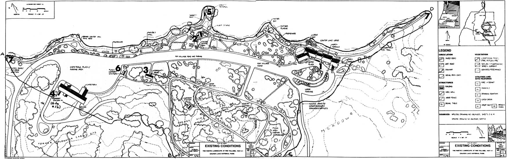
Rim Village Historic District
Beginning at the west end of the promenade’s parapet wall, 400 feet from the cafeteria plaza, proceed to the junction of Rim Village Road and the West Rim Drive, continuing in a line going southeast that stays 25 feet south of Comfort Station #72 and then follow the 7100 foot contour around the campground to a point where it crosses the road to the concessioner’s dormitory, thereafter passing 50 feet south of the lodge parking and going northeast along the promenade to a point 800 feet east of the hotel, then back along the caldera edge but encompassing Victor Rock and the Sinnott Memorial, to the point of beginning.
Delete boundary descriptions and UTM references on original form for the Sinnott Memorial, Comfort Station #68 (mistakenly identified as #65), and Comfort Station #72 by substituting those for the Rim Village Historic District. The district’s boundary includes the four areas or zones in Rim Village (promenade, plaza, campground, and lodge) historically part of the designed landscape and encompasses the contributing features identified in this amendment.
Munson Valley Historic District
Beginning at the junction of the Rim Drive and trail spur to the Castle Crest Wildflower Garden, then in a southwesterly direction to encompass the old road entrance to Park Headquarters and a paint shed (Comfort Station #37) to a point 15 feet south of the Machine Shop (building #5), continuing west to the outer edge of the maintenance yard, then north to pass just west of the Lady of the Woods, crossing the west branch of Munson Creek and continuing to the residence road, going along the road in a northwesterly direction to the Superintendent’s Residence, circling the residence, then east to the Naturalist’s Residence (building #20), passing north of the latter structure, then in a southeast direction crossing the east branch of Munson Creek and continuing to the point of beginning.
Revision of the district boundaries is necessary because the original form was based on erroneous reference points contained in a 1984 draft. That draft included all of the maintenance yard and an area between the yard and road which runs through Munson Valley, even though no contributing structure was located south of the Machine Shop. Subsequent cultural landscape recommendations for the site, published in 1991, did not identify any individual features in the area south of the Machine Shop as contributing to a historic landscape. This portion of the district, totaling 5 acres, should be deleted and total acreage of the district revised upward from the 7.5 acres indicated on the original form.
Acreage: Approximately 26 acres
UTM REFERENCES:
A 10/570840/4749440
B 10/570600/4749400
C 10/570500/4749920
D 10/570770/4749680
Crater Lake West, Oreg. 1:24,000
enlarge with a click
Information Source (National Park Service website): http://www.nps.gov/crla/nr1.htm
Creator of this PDF file: Robert Mutch, Executive Director, Crater Lake Institute, http://www.craterlakeinstitute.com
***previous*** — ***next***