
Crater Lake Waters
Each year, some three hundred seventy thousand visitors make their way to Crater Lake National Park. While their reasons for coming, and what they see and remember of the park, are doubtless as many and varied as are the visitors themselves, it is safe to say that, with very few exceptions, the center of their interest is Crater Lake itself. These beautiful waters – their color describable only as Crater Lake Blue — rest in the top of an ancient mountain whose summit was destroyed about 6,500 years ago.
An occasional visitor will step up to the rim, take a quick look, and say to his companion, “Well, we’ve seen it. Let’s go.” More often, however, the lake excites curiosity and prompts questions such as, “How did it come to be?,” “How deep is it?,” “How cold is it?,” “Are there fish in the lake?,” “Does it have an outlet?” and, “Does the water level vary?” The one of particular interest here is the last.
Although Crater Lake, deepest in the United States, was first seen by white man in 1853, dissemination of information was then so limited that two later, independent “discoveries” were made — in 1862 and 1865 (Runkel, 1953). Also, no serious scientific investigations within the area eventually to become Crater Lake National Park were made until the visit of the Joseph Diller party in the summer of 1886. At this time, the first Geological Survey map was constructed, soundings and temperatures of the lake waters were taken, and foundations were laid for what is now called the geologic story of Crater Lake. It was then that the deepest sounding of 1,996 feet was made.
Since that time, other soundings — notably those of John E. Doerr in 1939, then Park Naturalist at Crater Lake National Park and currently Chief Naturalist for the National Park Service — and studies of lake levels have been made. The earliest water-level records, aside from Diller’s of 1886, are largely obscure and of somewhat uncertain accuracy. Several are derived from names and dates painted by occasional visitors on rocks at the water’s edge. Some of these, however, are more or less readily relatable to later-established, known elevations and can be accepted with some validity.
The early picture is further confused by differences, unresolved by data presently available, in basic elevations established by the Diller party as compared with those on the current topographic map. For example, the lake-surface elevation, a figure subject to various types of fluctuations, was recorded for 1886 (Diller and Patton, 1902) as being 6,239 feet above sea level. This amounts to a difference of sixty-two feet from the 6,177 feet given on the most recent topographic map. Furthermore, all elevations of known stable points are of a magnitude greater than those on this 1946 edition – as well as on other available maps dating later than 1886. The disparities on specific points vary from as little as twelve feet to well over one hundred feet. It is understood, however, that elevations of many points throughout the western United States have been revised downward since Diller’s work. In order to arrive at a comparable figure, the differences of seven prominent rim points were averaged. This figure, seventy-one feet, was then subtracted from the 6,239 feet given for the lake level. The result is 6,168 feet, a value that falls nearly in the middle of the observed range of lake levels.
The first water gage on the shore of Crater Lake was erected for the Mazamas, a mountaineering club of Portland, Oregon, on August 22, 1896 (Diller and Patton, 1902). Diller states that it “was made of a board 5- 3/4 inches wide and 10 feet long, with scale subdivided to tenths of a foot. It was nailed to a log extending from the shore into the water, and zero of the scale was placed just 4 feet beneath the water surface, . . . Fearing that this fragile gage might not escape accident from rolling stones and sliding snow, W. W. Nickerson, of Klamath Falls, was requested to insert a bolt in a cliff near the gage and carefully determine the height of the bolt above the water and read the gage.”
The Nickerson bolt, a copper pin, was placed in position on September 25, 1896. The precaution was a good one, as the Mazama gage was cast adrift that winter, and the record book, contained in a copper box, was not recovered until five years later, on August 13, 1901. Two of Diller’s associates found it in Danger Bay in five feet of water, three and one half miles from Eagle Cove, the original location (Diller and Patton, 1902) The records were intact.
Diller, by referring to the record book, then painted a scale with the same zero point on a nearby rock face and inserted a pin, now known as the Diller Pin and still in place, at a point eight feet above zero point – four feet above the water level at the time that the original gage was installed. Diller (Diller and Patton, 1902) relates numerous water-level readings, including several incidental ones previously mentioned, to the Mazama gage. The earliest of these was September 10, 1892, when the water stood at 4.142 feet. The lowest such record reported by Diller was for September 26, 1893, when it was 2.52 feet, or 1.48 feet lower than the 1896 figure.
Since that time, four other gages — including the most recent, placed October 3, 1952 – have been installed and numerous readings taken, although not with complete regularity. It is evident that the earliest records were not related to elevations as were those of later years. Young (1952) indicates that in 1908 a U. S. G. S. benchmark, giving an elevation of 6,179 feet, was set near the water’s edge. It was from this benchmark that the levels of August 19, 1916, taken by F. F. Henshaw, District U. S. G. S. Engineer, were established. On the basis of his findings, the zero (datum) for the Mazama gage is placed at 6,173.64 feet above sea level. This places the oldest known related level (September 10, 1892) at 6,177.78 feet, and the 1896 level, when the Mazama gage was installed, at 6,177.64 feet. It is interesting to note here (Young, 1952) that the lake level reported by Diller — 6,178.545 feet, July 1, 1901 – records the lake at its maximum observed stage.
Records of lake level compiled by Ranger W. T. Frost (1937a, 1937b) indicate the level as remaining fairly constant. The greatest annual variation during the period of years from 1908 to 1913 was only 1.55 feet. No records were shown for the war years, 1914-1917. In 1918 there appears the beginning of a prolonged decline, which may actually have begun in the four previous years.
Frost’s notations carry through the year 1936 and show a general decrease in precipitation, correlated with the drop in lake level. He stated that the “Lake level is falling at an average rate of .51 foot per year. (Estimated from figures over a 26 year period).” He also stated that the average seasonal variation was 1.55 feet. In this connection, Diller (Diller and Patton, 1902) states that the annual “oscillation is limited to about 4 feet.” He says further that “the rising and sinking balance each other so that the lake maintains in general the same level.” This appears to be essentially true.
It seems possible that the annual fluctuation quoted from Frost may be somewhat less than total, since the lake is at its highest — usually in May or June — when it is least accessible for obtaining data. This appears to be the reason for Diller’s estimate of a maximum of four feet. Paul Herron, boat operator and engineer for the Crater Lake National Park Company, reported that the lake level for the 1954 season remained fairly constant at 6,176.9 feet during the first twenty days of June, after which it began to recede gradually. The last reading taken prior to the time of this writing was made on August 18; this report was 6,176.26 feet, representing a drop of 0.64 foot in approximately two months. The lowest level, however, should be expected at sometime in October, after the beginning of fall rains and snows.
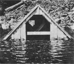 In the fall of 1942, the sills of this 10-foot high boathouse stood 18 inches above the lake water level. From a Kodachrome, taken in August, 1954, by C. Warren Fairbanks |
Recession of the lake level during these years, 1918-1936, continued until 1940, when the all-time low of 6,162.3 feet was recorded (Young, 1952). From that date until the present, Crater Lake has risen steadily, for an observed total of 14.6 feet in fourteen years — an average of 1.043 feet per year. The level this year falls within the range of high levels which extended from the 1890’s through 1913.
As has been mentioned previously, the highest observed level was recorded by Diller in 1901. This figure of 6,178.545 feet, when considered together with the 1940 low, indicates an all-time observed fluctuation of 16.245 feet.
There is, however, some evidence of a higher level at some time in past. Gordon Hegeness (Williams, 1942), formerly a Ranger Naturalist at Crater Lake National Park, found a deposit of diatoms — microscopic water plants which have siliceous walls — on Wizard Island, approximately fifty feet above the water level. Williams uses this evidence to assume a former high level of that approximate magnitude. The location of this find apparently was not recorded, and analysis of that material to determine its significance has not been possible. Investigations carried out this summer, however, have contributed significantly to our knowledge on this point; the results are reported upon elsewhere in this issue (Rowley and Showalter, 1954).
There is some evidence from another source which indicates a slightly higher level in the past. A definite line formed by the drowning-out of lichens — primitive plants which can gain a foothold on bare rock faces – is observable a few feet above the present water surface.
Young (1952) uses field notes of F. F. Henshaw and of J. S. Brode, another former member of the naturalist staff at Crater Lake National Park, to arrive at the figure of 6,180.9 feet as the probable highest level of the lake, at least in recent decades.
Thus it may be seen that the surface level of Crater Lake fluctuates in response to both seasonal and climatic variations. The former, resulting primarily from differences in the amounts of precipitation and run-off at various times of the year, occur relatively rapidly but are moderate in range. The latter operates over longer periods of time but are ultimately responsible for greater extremes.
References
Diller, Joseph S., and Horace B. Patton. 1902. The Geology and Petrography of Crater Lake National Park. Washington, Government Printing Office. 167, iii pp.
Frost, W. T. 1937a. Snowfall — precipitation and lake levels. Crater Lake National Park Nature Notes 10(1):3-7.
—–. 1937b. Errata. Crater Lake National Park Nature Notes 10(3):43.
Rowley, John R., and Wendell V. Showalter. 1954. Wizard Island, an index to the past?Nature Notes from Crater Lake 20:26-31.
Runkel, H. John. 1953. Crater Lake discovery centennial. Nature Notes from Crater Lake19:4-9.
Williams, Howell. 1942. The Geology of Crater Lake National Park, Oregon. Carnegie Institution of Washington Publication 540. Washington, D. C., Carnegie Institution of Washington. vi, 162 pp.
Young, Charles A. 1952. Report on Crater Lake gages and elevations from 1892-1951. (MS. in Naturalist Files, Crater Lake National Park Naturalist Office).