
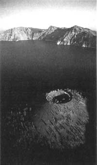
Ancient Remnants in Snow Crater
Craters are geological features usually associated with composite volcanoes and the top of cinder cones. Found throughout the park, they are generally less than a kilometer (5/8 mile) across and formed when volcanic material is ejected through a vent of an active volcano. Calderas, by contrast, represent volcanism far beyond the activity that is typical of eruptions associated with craters. To put this in perspective, the four to six mile-wide depression filled by Crater Lake is a caldera while the crater on Wizard Island’s summit is only a couple of hundred yards across.
 Wizard Island has a crater; Crater Lake is inside a caldera. |
That crater on Wizard Island formed after Mount Mazama’s climactic eruption, so it is clearly discernible. Cinder cones such as Crater Peak, Maklaks Crater, Red Cone, and a number of unnamed points on the park map have craters obscured by erosion, pumice and ash because they appeared prior to the cataclysmic event of roughly 7,700 years ago.
Although not abundant, the park contains several post-Mazama craters in addition to the one on top of Wizard Island. One easily reached by a short walk from the west rim drive near Hillman Peak is Williams Crater, sometimes called Forgotten Crater on older maps. Another one is located some distance from any road, near the park’s south boundary. Scoria Cone is quite unlike the other two, in that it has an exposed crater-like depression or what some geologists have described as a pit crater.
Most, if not all, of Scoria Cone resulted from a north-south fissure through which lava extruded 25,000 to 45,000 years ago. It is one of three prominent cinder cones built on well-rounded lava flows whose appearance show evidence of glaciation, much like those in the vicinity of nearby Union Peak. Like many other cinder cones, Scoria Cone has a crater filled with pumice and ash. There is, however, a deep rectangular depression or pit on the north end of the older crater floor. Measuring roughly a hundred yards long and 50 yards across, the pit has precipitous walls dropping away some 130 feet to the top of a snow and ice plug.
In the 1940s one park naturalist noticed that snow in this plug is permanent, even when summer melting in other parts of the park has long dispatched any sign of winter. He named it Snow Crater, not knowing that the snow and ice extended 150 feet down a chimney which once provided the conduit for lava sometime in the past. He could not know because few people are foolhardy enough to try a descent to the plug, let alone attempting to go between the conduit’s walls and the ice.
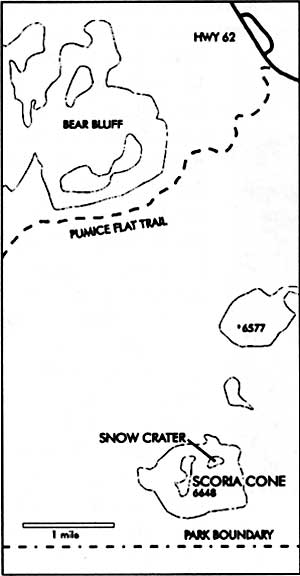
Map by Susan Marvin.
Even so, in 1977, after one of the driest years on record, a team of park rangers explored where no one had ever been previously. They reached the plug’s bottom and found several rooms of various sizes. Two of the rangers retrieved pieces of wood entombed in ice from near the bottom of the plug. One of these specimens was subsequently identified as Douglas-fir, Pseudotsuga menziesii, by a wood technologist at Washington State University. Its resting place piqued the curiosity of researchers connected with the park, as no Douglas-fir are known to occur presently at 6,300 feet anywhere near Crater Lake. Although badly degraded, the wood showed breakdown in cellular structure that is caused by hot water or steam. This led to speculation that the fragment might have been in the pit crater while it was still active.
Although radiocarbon dating of this wood held the prospect of providing additional insight to mysteries surrounding volcanic activity at Scoria Cone and the vegetation history of this area, no one could secure funding for necessary laboratory work for the next 17 years. Only in 1994 did a sample specimen finally reach a radiocarbon dating lab for an age determination. After calibration (since radiocarbon years may be tree ring corrected to reflect calendar years) it was reckoned that this piece of Douglas-fir is approximately 3,640 years old. The obvious interpretation of this evidence is that a mixed conifer forest, as seen today in the park’s panhandle (the irregularly-shaped parcel of land near the south entrance), flourished at Scoria Cone during a period of warm-dry summer climate roughly 4,000 years before the present. Since conifers such as Douglas-fir are long-lived, the wood sample may indeed be one of the last of this species to grow near what became Snow Crater at Scoria Cone. The nearest forest of similar composition 3,600 years later is located a few miles downslope, but at 4,500 feet in elevation near the park’s south boundary.
Since three of us felt the need to locate any Douglas-fir presently living close to Scoria Cone other than those previously mentioned, we hiked there on August 25, 1994. After 30 minutes on the Pumice Flat Trail, it took another hour or so by traversing cross country to reach the top of a cone just north of our destination. We could find no evidence of Douglas-fir along the way, nor did any appear on the short jaunt to Scoria Cone. Instead we found a subalpine forest of lodgepole pine, Pinus contorta v. murrayana, western white pine, Pinus monticola, true fir (white fir, Abies concolor, and red or noble fir, A. magnifica-procera), and mountain hemlock, Tsuga mertensiana.
Once we reached Snow Crater, it did not take long to realize why the rangers of 17 years earlier felt justified in closing this vent to any future explorations. Remnants of wooden park signs to this effect could still be seen as we walked around the pit’s perimeter. It was then that our attention became riveted to a curious three-needled pine clinging to the precipitous north wall some 200 feet above the plug of snow and ice. Just why it is there constitutes an interesting question. Surprisingly enough, what has been called Ponderosa pine, Pinus ponderosa, in lower elevation mixed conifer habitats can be found today in small subalpine habitats near Crater Lake’s caldera rim, and on warmer southwest slopes of cinder cones within and near the park. In addition to the possibility of this three-needled pine being ponderosa, there are at least two others. These include Jeffrey pine, Pinus jeffreyi, whose northern distribution is on serpentine substrates near the Illinois Valley over 100 miles southwest of Crater Lake, and Washoe Pine, Pinus washoensis, a rare and almost unknown species found in the mountains bordering the Great Basin.
Trees can often serve as thermometers with sensitivity to temperature changes induced by fluctuations in climate. Cold abbreviates the length of growing seasons, thereby limiting critical processes such as photosynthesis. The result is a narrow growth ring and long periods without viable seed production. Even cold-hardy ponderosa pines would find survival in the short growing seasons and frequent deep snowpacks of subalpine habitats difficult.
The mixed conifer forest (with Douglas-fir as an associate) seen today within the neighborhood of the park’s panhandle has not always been situated there. At the time of Mt. Mazama’s great eruption, 7,700 years ago, a climatic interval known as the Altithermal or Hypsithermal Period was underway. It began some 8,000 years ago and persisted for approximately four millennia. Marked by significantly warmer and dryer summers than at present, this time featured climatic changes which altered growing conditions which favored the upslope migration of the mixed conifer forest. Associated advances and retreats of forest community borders along elevational gradients are well documented throughout western North America.
Changes in vegetation zone elevations are affected by shifts in critical growing season temperature and moisture regimes. A shift to cooler, more moist conditions following the Altithermal Period spurred a retreat of the mixed conifer forest to lower elevation habitats over the past few thousand years. Isolated and disjunct stands of three-needled pines within the subalpine zone today represent local pine variants. As relicts of past environments, they may link prehistoric forest assemblages to our time and place. The sentinel pine grasping the volcanic rock for moisture and nutrients above Snow Crater may hold one key for gaining a better understanding of the linkage between past and present. Our visit to Scoria Cone provided an opportunity to interpret the present scene and wonder about the relationships resulting from those geologic, climatic, and biological forces present during the era when a 12,000 foot Mount Mazama dominated the landscape.
Steve Mark is the park historian at Crater Lake. He has been editor of Nature Notes since its revival in 1992.
Ron Mastrogiuseppe is a former seasonal employee at Crater Lake. He is now based in Burns, Oregon, where he is an ecologist.