
‘Lost’ Lost Creek
Southeast of Crater Lake, not far above the confluence of Wheeler and Sand Creeks, is a small stream called Lost Creek (see figure 1). Most park visitors are unaware of its existence. Those who take note of it typically do so when stopped at the Lost Creek Campground where they find the small stream flowing quietly through the woods immediately west of the camp area.
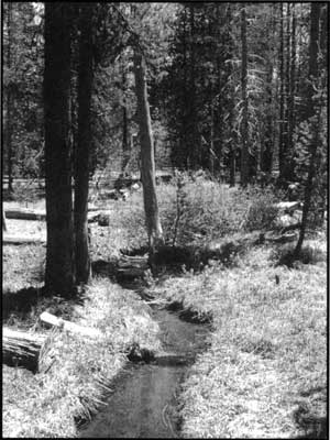 Lost Creek. Photo courtesy the author. |
Lost Creek pours full-blown from a spring on the face of a steep slope about one kilometer northwest of the campground. It flows unpretentiously through the woods past the campground until the stream vanishes completely into the porous soils of the area located another kilometer to the south-southeast of the campground. Over its course Lost Creek receives no flow from tributary streams, and the fact that it disappears from view before joining another stream presumably accounts for the ‘Lost’ in its name. The spring from which the creek comes serves as the water source for the Lost Creek campground, and the stream itself hosts a small population of native bull trout that were introduced in the late 1990s (visitors should note that fishing in Lost Creek is prohibited). The banks of the creek, especially in its lower reaches, display a goodly collection of local wildflowers at appropriate times of the year.
This stream can also be characterized as ‘lost’ in ways other than just its hydrographic character. Lost Creek (or at least some stream, if not the one we see today) appears on early maps of the area. The second illustration (figure 2) shows the vicinity highlighted on the first figure as presented on the United States Geological Survey’s map of 1911. This map showed the park at a scale of 1:62500, and was based on plane table surveys in 1908 and 1909. The creek in question is the diagonal line passing through the large capital ‘R’ from mid-section 18 through the upper right corner of section 19 and into section 20 to the lower right. The intermittent stream that goes from west to east through the text ’18’, terminating at its presumed confluence with Sand Creek, should draw a discerning eye. At this point also notice the short creek paralleling our assumed Lost Creek, from just above the ‘er’ at the end of ‘Wheeler’ down to an intersection with Wheeler Creek. Which of these three creeks, if any, is really Lost Creek?
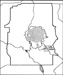 Figure 1. Lost Creek in relation to Crater Lake National Park. |
The next illustration (figure 3) shows the same area as presented on the USGS 1:62500 sheetCrater Lake National Park and Vicinity, Oreg.,published in 1956 but based on the same survey as was the 1911 map and augmented by work in 1933. Here the map looks sharper, but upon close inspection one finds that all that has been added is typography, roads, and a benchmark; the same three streams we saw in the 1911 information are still there, and the contour lines remain unchanged.
Figure 4 shows the same area compiled from the USGS’s Digital Raster Graphic (DRG) editions of the 1:24000 quadrangle maps Crater Lake Eastand Maklaks Crater. These maps were originally published and distributed on paper, but the paper and digital editions are essentially identical; the paper editions were published as Provisional Edition sheets (whence the crude typography and overlaid symbology) in 1985. Both are derived from aerial photography done in 1981 and 1982, with field checks conducted the latter year. There is but one creek on these sheets: the two small ones shown in earlier editions of the maps (the one in the upper part of section 18 running into Sand Creek and the one in the east-center of section 19 running into Wheeler Creek) are now gone. The stream named Lost Creek has been repositioned and is shown running into Wheeler Creek through the tributary canyon previously occupied by the smaller unnamed creek. Lost Creek is wandering around in the woods now, obviously lost.
Park staff conducted field survey work in the Lost Creek vicinity using high-quality differential global positioning systems techniques early in the summer of 2000. The work was originally initiated to clarify the actual position of Lost Creek so that a zone could be defined around it within which the use of fire-retardant chemicals as a fire-control measure would be prohibited. This measure is aimed at protecting the bull trout population in Lost Creek in the event of wildland fire in the area. We found Lost Creek and some other lost creeks in conducting this survey.
Figure 5 shows stream structures revealed by the survey. For the first time we can see what is actually the case in that area: there are three streams after all, and only one of them (the most southerly of the original three) is more or less correctly placed. It was shown correctly on the 1911 and 1956 maps, only to be abandoned on the 1985 versions. This illustration contains road and contour line data derived from USGS Digital Line Graph (DLG) data sets, and is information based on the same surveys used for the 1985 1:24000 quadrangle maps noted above. The streams from the 1985 sources are shown as dashed lines, and the stream positions from our field work are shown as bold lines. Lost Creek is named according to official nomenclature, but we have added unofficial names for the other two flowing streams in the vicinity: “Hopelessly Lost Creek” and “Mason’s Creek.” The latter are strictly local names bestowed by the surveyor, and are not designations approved by the National Park Service or the U.S. Board on Geographic Names.
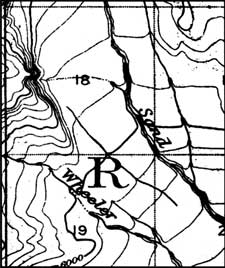 Figure 2: Lost Creek vicinity as depicted on the USGS map of 1911. |
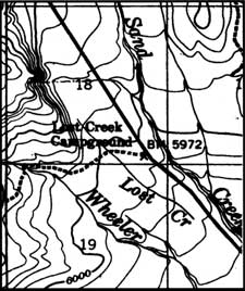 Figure 4: Lost Creek vicinity as depicted on the USGS (Digital Raster Graphics) edition of 1985. |
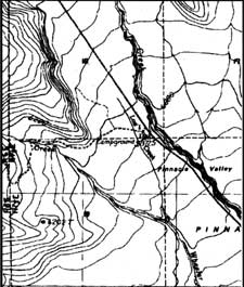 Figure 3: Lost Creek vicinity as depicted on the USGS map of 1956. |
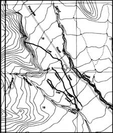 Figure 5: Shows stream structures revealed by park staff survey work. |
It seems that the stream we have called Hopelessly Lost Creek is the same as the one shown in that location on the 1911 and 1956 publications. Mason’s Creek has not previously appeared as an identifiable stream on any USGS map. Lost Creek is there, all right, but its upper and lower extremities differ markedly from the information shown on published maps. The northerly unnamed stream shown first in 1911 is not a part of the complex of creeks in the Lost Creek area. Its source, as shown in 1911, is actually the source for Lost Creek.1
Results from this latest survey illustrate some of the problems associated with the making of accurate maps. The surveys of the late nineteenth and early twentieth centuries in the American west were conducted by real people. They took with them significant quantities of moderately heavy equipment, and surveying with a plane table and rod took a lot of time to cover significant areas. Not all areas got surveyed with equal attention to detail. In this case it seems reasonable to believe that the survey crew perhaps passed up the north side of the Wheeler Creek gully, and in so doing, mapped the southerly small creek with some care. They then went on without looking carefully for other details. This or another crew might have also passed up the west side of Sand Creek, and subsequently inferred the details of the supposed drainage into that gully. None of them explored with care the interfluve between Wheeler and Sand Creeks, but someone must have passed through the area and noted the presence of what subsequently came to be named Lost Creek.
Oddly enough, the ability of surveyors to see small things on the land diminished considerably as technology evolved. Instead of actually sending people with mules out to look at the ground, aircraft were used to photograph the ground from above. To a large degree, the things that cannot be seen on such photographs are not featured on the resulting maps. As a case in point, we have three small streams that are not wide enough to be seen as an open stream on such photographs as were used for the 1985 maps. These streams are sufficiently narrow that they do not even create a consistent opening in the vegetative canopy overhead.
Lost Creek is by far the largest (in terms of flow volume) of the three streams, at least along its upper end. Nevertheless, it has no significant drainage channel cut down into the landscape downstream of the uppermost few hundred meters of its course. As a result, there is no incised channel associated with it (either at actual ground level or reflected at the top of the vegetative canopy) that might be detected by the photogrammetric means used to create contour lines from aerial photography. The vegetative cover associated with the stream banks is the same as that found away from the streams, and thus there is no consistent tone or color distinction to be made between the near-stream vegetation and the surrounding vegetation that might hint at the presence of a stream. Unlike Lost Creek, however, both Mason’s Creek and Hopelessly Lost Creek do have significantly incised drainage channels from their heads down to their combined confluence with Wheeler Creek.
By studying the 1911 map (Figure 2) we see that the channel for Hopelessly Lost Creek is reflected in the shapes of the contour lines across which its course passes. The topographic expression of that channel is much subdued in the 1985 mapping, but it is still there albeit with no stream. The Mason’s Creek channel is not discernable as a topographic feature on any of the maps.
Prior to our survey, local wisdom in the park seemed to suggest that Lost Creek was, in fact, connected to Wheeler Creek, and that at times of high water, it might actually have flowed freely to Wheeler Creek. There is no evidence on the ground that Lost Creek has had a direct connection to Mason’s Creek, and thus to Wheeler Creek, in historic time. A superficial Lost Creek channel can be traced for several hundred meters below the present termination of typical springtime high surface flow, but this channel wanders down the high ground above Wheeler Creek by staying essentially parallel to the Wheeler Creek channel axis. The lack of a previous connection between Lost and Mason’s creeks seems surprising, given that the two come within approximately 50 meters of one another at their point of closest approach. There is, however, simply no hint of any cross-connection ever having been present in this vicinity. Lost Creek appears to have always been perched above Wheeler Creek, situated there all by itself—and indeed lost.
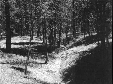
The dry stream bed of Mason’s Creek. Photo courtesy the author.
What you often see on maps is not necessarily what you will find if you go there. There are very good reasons why this can be true. The Lost Creek vicinity at Crater Lake National Park provides a tidy case study of how and why the differences can occur. There are also other questions that could be studied here, for those so inclined. One should be why, if Lost Creek is the largest of the three creeks, is its drainage channel not incised into the land to any degree? Another relates to why, if Mason’s Creek and Hopelessly Lost Creek have significantly developed incised channels, do they each have minimal flow—to the point of being dry over most of their lengths during much of the year? It is also worth asking why, with its source springs and seeps right next to the Greyback Road where the old trail to Mason’s camp sets off, did Mason’s Creek never appear on published maps?
Notes:
1Our survey did not go north of the Lost Creek springs. There may well be something draining from further north into Sand Creek at the confluence location shown.
Phil Kelley formerly taught geography at Mankato State University, Minnesota, but is currently the Geographic Information Systems Specialist at Crater Lake National Park.