
Witness to a Catastrophe
The eruptive collapse of Mount Mazama represents the biggest volcanic event to occur in North America over the last 10,000 years. Massive deposits of scoria and pumice blasted the volcano’s slopes and still continue to fill the stream drainages in the surrounding region. Remains of an ancient forest can still be seen beneath this material in many of the road cuts around the park. It is evidence of destruction involving 12 cubic miles of ash and pumice. A caldera resulted from this destruction about 7,700 years ago, replacing an edifice that may have reached 12,000 feet high. Few places were left unaffected by this catastrophe, but one peak fared better than most.
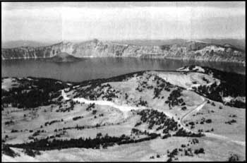 The view from Mount Scott. NPS photo. |
Following Mazama’s climactic eruption, the summit of Mount Scott became the highest point in the immediate vicinity with an elevation of 8,929 feet above sea level. Mount Scott was named in honor of Levi Scott, a man who explored southern Oregon in the middle of the 19th century. Its name in the Klamath language is Tum-sum-ne orTomsandi. The geological origin of this peak has been re-examined in recent years, with improved dating techniques allowing Dr. Charles Bacon of the U.S. Geological Survey to better fit this peak into the broader story of Mount Mazama.
Dr. Howel Williams, who wrote The Geology of Crater Lake National Park some 60 years ago, believed that Mount Scott developed late in the history of the great volcano. He described Mount Scott as a “parasitic” cone that owed its existence to the larger Mazama. Modern radio-metric dating methods have allowed Dr. Bacon to amend Williams’ assessment. Not only is Mount Scott now believed to be a part of a complex of cones that combined to form Mount Mazama, it is possibly the oldest member of this complex.
The silica-rich lavas of Mount Scott have been dated to 420,000 years, roughly 20,000 years older than any other rocks found immediately around or within the rim of Crater Lake. The great age of these flows has helped to explain why the cone is so eroded in its appearance. Seen from the east, Mount Scott has a conical shape. When seen from other directions, however, a broad amphitheater quickly becomes apparent. With its central core missing, it is easy to wonder about the cause of such great alteration in what was originally a great cone.
Mount Scott, like all other surrounding features, was blasted by avalanches of hot pumice and scoria during the climactic eruption of Mount Mazama. The real dint to its shape, however, took place centuries prior to the big blast. During at least three, and possibly four extended periods, glaciers advanced over this and other peaks in the Cascade Range. Ice slid down and created the west slope that geologists call a cirque. The abrasive effect of these mile-thick rivers of ice should not be trivialized. The broad slopes surrounding Mount Thielson, located north of Mount Scott are missing altogether because of what the glaciers carved. The same can be said for Union Peak, a promontory situated some 10 miles to the southwest of Mount Scott.
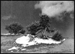 Whitebark pines. NPS photo by Jack Boucher, 1960. |
The pumice and scoria now covering flanks of Mount Scott eventually became a suitable habitat for subalpine trees. Whitebark pines(Pinus albicaulis) are especially adapted to the higher elevations . Their flexible limbs bend easily under the weight of the heavy winter snow pack. Clusters of needles, five in a bunch, are assembled at the ends of branches and give each the appearance of a bottlebrush. As you ascend the Mount Scott Trail, take notice of how these trees become visibly shorter with elevation. A reduced growing season has both depressed the numbers of these trees and their size. The prevailing wind has also shaped their appearance, especially within the cirque. Trunks and limbs all bend back and away from the strong winds that come across Crater Lake from the west.
A splendid view from the top rewards everyone who climbs to the top of Mount Scott. Looking east, across the Klamath Marsh, observers often see expanding cumulus clouds on warmer summer days. The Three Sisters, located a hundred miles north, display icy tops just barely visible to the left of Mount Thielson on clear days. The best view by far, and one that draws considerable attention, is the view of Crater Lake. Nowhere else in the park do observers see the entire display of island, rim, and water as well as from Mount Scott. Perhaps the combination of being up high enough, and a bit removed from the rim of Crater Lake, allows for a new perspective on the decapitated mountain.
As previously indicated, Mount Mazama was not a single cone. Just as the Three Sisters and Broken Top are considered a volcanic complex, so too was the Mazama volcano. The difference here, however, was that most of the units that combined to form Mount Mazama were so close together that their lava overlapped. The exception, of course, was Mount Scott. All members of the Mazama complex derived their fluids from the same magma source beneath the surface. Mount Scott formed first and others followed to the west of it.
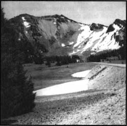 Mount Scott from Rim Drive, where the glacial cirque is plainly evident. NPS phto by Bruce Black, 1959. |
Fortunately for those who appreciate Mount Scott in the present, it was located too far east to collapse into the same magma chamber as Mazama had 7,700 years ago. During the climactic eruption, however, an observer on Mount Scott would have been in great danger. Avalanches of hot pumice and scoria raced down the slopes of Mount Mazama and boiled over the top of Mount Scott. Fallout from a four-mile high plume of pumice also landed on the top of this cone.
It is difficult, when standing on top of Mount Scott, to comprehend the catastrophe that occurred here almost eight millennia ago. The peaceful setting of this place adds to a deceptive illusion of permanence. It is worth remembering that geologists have determined that the source of Mazama’s climactic eruption is still intact, and fully capable of building new volcanic edifices here in the future.
Tom McDonough first came to work at Crater Lake as a seasonal naturalist in 1969 and has taught science at Chemeketa Community College in Salem, Oregon, since 1975.