
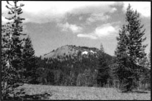
 Red Cone illustrating pyroclastic debris and forested northern slope. This cinder cone is typical of the small monogenetic volcanoes related to Mount Mazama outside the caldera. Photo by the author. |
All of the Crater Lake cinder cones are similar in composition. One method of describing and comparing the composition of volcanic rocks is expressed by how much silicon (Si) and oxygen their rocks contain. Reports of chemical analysis combine these two elements and express them as the percentage of SiO2. The great majority of cinder cones found in the park have a SiO2 range of between 52% and 58%, thus producing igneous rocks called basalt or basaltic andesite.
Based on the amount of weathering, soil cover, erosion and a few radiometric dates (the measurement of geological time by means of the rate of disintegration of certain radioactive elements), most cinder cones in Crater Lake National Park appear to be less than 50,000 years old. Radio-metric dates (using the potassium-argon method of dating, or K-Ar) have been made on rocks from four cones: Timber Crater, Red Cone, Scoria Cone and Desert Cone. Only the results for Desert Cone indicate an earlier formation with a date of about 200,000 years. It should be noted, however, that the ages resulting from such techniques have a very large range. For example, the age for Red Cone rocks is recorded as 36,000 years before present, plus or minus 12,000 years.
Williams Crater & Wizard Island
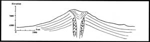 Figure 3: This east-west profile of Red Cone illustrates the typical shape of cinder cones at Crater Lake. Slopes for cones outside the caldera suggest some decrease from the original shape due to erosion. Angles for young, fresh cinder cones tend to be about 30°, similar to that of Wizard Island which has a slope of 29°. Sketch by the author. |
Just outside the west caldera rim a small cinder cone can be found called Williams Crater, previously labeled as “Forgotten Crater” on older maps. This feature may provide an interesting insight into the nature of the magma sources that produced Mount Mazama and the climatic eruptions. Some erupted materials appear to be formed from “mixed magmas” and contain both low and high SiO2 compositions. These have been interpreted as a mixing of the two different magma sources associated with the Mount Mazama region – the deep magmas and the climatic eruption magma source. Based on glacial erosion and other evidence, Williams Crater appears to have been active between 22,000 and 30,000 years ago.
All the volcanic features on the floor of the Crater Lake caldera developed after the collapse of Mount Mazama. Soon after the climatic eruption and collapse that created the caldera, renewed volcanic activity formed the central platform, Merriam Cone, Wizard Island, and other features. An estimated 3 km3 of post caldera volcanic material was erupted through a ring fracture system – most of it part of the Wizard Island edifice. Merriam Cone, rising some four hundred meters above the caldera floor, has the general appearance of a small cinder cone. Recent evidence, however, suggests it was formed below water. Wizard Island’s cinder cone rests on top of a pile of lava flows that extend eastward over the central platform.
Several research devices and techniques were used to map the topography of the caldera floor and investigate the nature of the rocks and sediments that occur in the Crater Lake basin. Rock samples collected from some 250 feet below lake level, on the flanks of Wizard Island, appear to have been in placed under water. The composition of these samples is identical to the youngest sub-aerial flows of the island’s cinder cone located above them. All this suggests that Wizard Island was built on top of lavas erupted to create the central platform in the rising waters of Crater Lake.
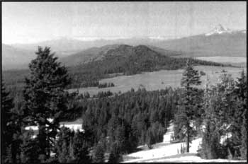
 Timber Crater across Pumice Desert as viewed from the North Entrance road. This cone, resting on the summit of a small shield cone, is the largest cinder cone in Crater Lake National Park. Photo by the author. |
The maximum age of Wizard Island and Merriam Cone is constrained by the date of Mount Mazama’s collapse a little less than eight thousand years ago. There are various estimates of how long it took for the lake to fill to its current level. Other evidence suggests that Wizard Island formed very early in the history of the basin. Using radiocarbon (C-14) dates for the collapse, and allowing a few hundred years for the lake to fill, places Wizard Island’s age at about 7,000 years before the present. Its conical shape gives Wizard Island the look of a young feature, having suffered little erosion. Since there are no “hot” areas outside the caldera to suggest remnant volcanism, the lava flows at the western base of Wizard Island may represent the most recent volcanic activity in the park.
Over the past 20 years, a large, number of publications have resulted from intensive geological fieldwork. These efforts have concentrated on the construction, climatic eruptions, and ultimate collapse of Mount Mazama, resulting in the Crater Lake caldera. This is, of course, the geological story to be presented at Crater Lake National Park—the very reason the park was established. Other geologic features, such as the cinder cones, however, are also worthy of further investigation.
K.R. “Rod” Cranson is a geologist who worked at the park twice, 1967-68 and 1978-82. He is currrently in the midst of preparing a third edition of his book, Crater Lake: Gem of the Cascades.