
Biking Crater Lake
Increasing numbers of cyclists are coming to Crater Lake National Park to ride around the lake on the 33-mile Rim Drive. The route is physically demanding. Steep hills at high elevation may encourage even the most fit riders to pause at many of the road’s thirty overlooks and pullouts. The payoff, however, is spectacular scenery, seen at a pace that few visitors choose to take enough time for.
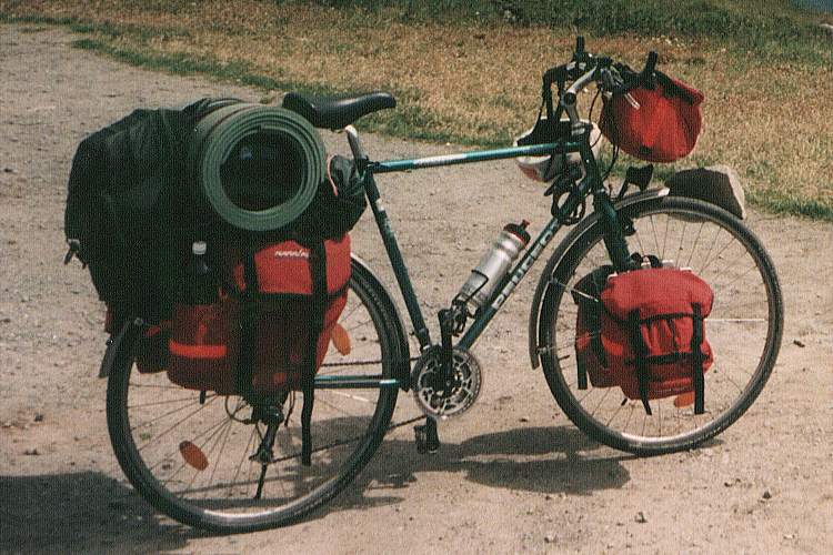
Packed and ready to roll – no one can appreciate how wobbly a fully-loaded bike can be until they’ve tried it. Take care passing a bike like this with your car or especially with an RV. The draft alone can toss the rider into the ditch.
Rules and Safety Precautions
- Cyclists must respect and obey all rules that apply to automobile traffic, including speed limits.
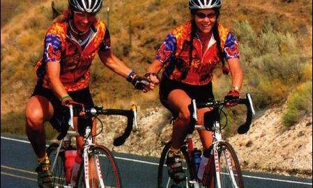
- Bicycle helmets are required. Cyclists face many hazards, including high speeds on steep downhill runs; rocks, animals, and other road hazards; and heavy traffic.
- Only cyclists experienced at riding with auto traffic should consider biking at Crater Lake.
- Park roads seldom have shoulders. Cyclists should use extreme caution, particularly along narrow areas and blind curves. Wear bright, highly-visible clothing to help drivers see you.
- Bicycles are not permitted on park trails. All roads closed to automobiles are also closed to bicycles.
- For mountain biking, the Grayback Drive provides eight miles of unpaved, one-way road.
- Cyclists unaccustomed to high altitudes may find that the elevation makes for difficult breathing.
- Water is available only at Rim Village and Park Headquarters.
Getting Here by Bicycle
All routes into the park have long, steep grades. Because road conditions are unfavorable to cyclists most of the year, and because many roads are closed during the long winter, we recommend you plan trips only for the summer months of July, August, and September.
See Current Conditions and past weather history.
Entrance stations provide maps and information during summer daytime hours. Fees are $10 to enter the park by automobile for 7 days, or $5 per bicycle up to a maximum of $10 per family.
The Crater Lake Century
Dubbed “The Best Ride in Oregon” by Bicycling Magazine, The Crater Lake Century is an annual bike ride that traverses up and around the Crater Lake Caldera.
Available in 62-Mile and 100-Mile routes, the ride begins and ends at the historic Fort Klamath Museum. The annual ride is a benefit for both the Klamath County Museums and the Klamath-Lake Counties Food Bank. Over the previous 8 years, the ride has contributed over $60,000 to these organizations.
See more here at the Century website.
The Rim Drive
The most popular bicycle route at Crater Lake is the 33-mile Rim Drive. This road provides spectacular views of Crater Lake and the surrounding area throughout its length. The road is narrow with long, steep grades. Most cyclists start from the Park Headquarters area and ride around the lake clockwise. This direction puts one of the steepest and longest grades at the beginning of the trip.
Altitude, climb, and distance estimates are listed below, assuming a clockwise trip.
This is an interactive map. Click on it.
This is a link to the Google Earth map file
|
Map |
Point name |
Total mileage |
Distance from last |
Climb (feet) |
Elevation (feet) |
|
|
Park HQ |
0.0 mi | 0.0 mi | 0 | 6500 |
|
|
Rim Village |
3.0 | 3.0 | 600 | 7100 |
|
|
Discovery Point |
4.1 | 1.1 | 50 | 7100 |
|
|
Watchman Trailhead | 6.8 | 2.7 | 400 | 7350 |
|
|
North Junction |
9.1 | 2.3 | 200 | 7050 |
|
|
Cleetwood Cove | 13.7 | 4.6 | 450 | 6850 |
|
|
Wineglass |
16.5 | 2.8 | 350 | 6700 |
|
|
Skell Head |
17.9 | 1.4 | 400 | 7100 |
|
|
Cloudcap |
20.9 | 2.6 | 600 | 7700 |
|
|
Kerr Notch |
24.4 | 3.5 | 0 | 6700 |
|
|
Dutton Ridge |
27.0 | 2.6 | 650 | 7350 |
|
|
Vidae Falls |
30.0 | 3.0 | 0 | 6600 |
|
|
Park HQ | 33.0 | 3.0 | 100 | 6500 |