
Bert Creek Trail – Crater Lake National Park
Difficulty: Moderate
Length: 1.93 mi (3.11 km)
Elevation: 5643* – 5545† ft (1720* – 1690† m)
Elevation: 5233 ft (1595 m)
REI Trails Project partners with Crater Lake Institute to produce their trails app. Click the map below, get the app – then come back, we offer more. View all trails here.
Trailhead coordinates:
Latitude: N +43° 00.38 or 43.00640
Longitude: W -122° 14.89 or -122.24827
Altitude: 5643* ft (1720* m)
*at Bald Crater Loop Trail intersection †at western border of Crater Lake NP
Trail Description
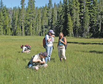
This trail is commonly used as access to Sphagnum Bog at Crater Springs (see related material to the right). Mountain hemlock and shasta red fir are the primary forest cover beginning at the park boundary.
Sphagnum Bog is a wet meadow (technically, a fen) filled with fragile bog dwelling plants. Use extreme care while traveling in this delicate ecosystem.
Trailhead location: From Prospect, OR, travel north on Highway 62 until reaching the junction with Highway 230. Continue on Highway 230 for 6 miles to the junction with Forest Service road 6530. Turn right on road 6530 and continue 1.3 miles to the second junction with loop road 6535. Follow road 6535 for approximately 5.3 miles , TURNING LEFT ON ROAD 660 to the trailhead. The trail begins a slight upward climb to a gate on the upper end of road 6535. The trail continues beyond the gate for 0.5 mile before reaching the west boundary with Crater Lake National Park. A short distance inside the park, at the junction with the Bert Creek Trail, a sign reads Sphagnum Bog 1.7 miles.
Seasonal Information: Expect the trail to be covered in snow from October to early July, however, conditions vary somewhat from year to year. See Crater Lake Current Conditions for more information.
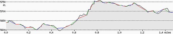 Bert Creek Trail Elevation Profile
Related Maps
Digital USGS topographic maps (PDF files) – the following maps are relevant to the Bert Creek trail. See more Crater Lake Institute online USGS digital maps.
| Series | Name | Year | Scale | Contour Interval | File Size |
| USGS 7.5′ | Hamaker Butte | 1985 | 1:24,000 | 40 ft | usgs-hamaker-butte-7.5 |
| USGS 7.5′ | Pumice Desert West | 1985 | 1:24,000 | 40 ft | usgs-pumice-desert-west-7.5 |
| USGS 30′ x 60′ | Crater Lake | 1989 | 1:100,000 | 50 m | usgs-crater-lake-30-minute |
| USGS 1° x 2° | Klamath Falls | 1970 | 1:250,000 | 200 ft | usgs-klamath-falls-1-2 |
| USGS 1° x 2° | Medford | 1976 | 1:250,000 | 200 ft | usgs-medford-1-2 |
| USGS 1° x 2° | Roseburg | 1970 | 1:250,000 | 200 ft | usgs-roseburg-1-2 |
|
Please remember to practice “leave no trace outdoor ethics” when you are out on Crater Lake National Park’s trails…and have fun! |
***previous*** — ***next***