
Draft Winter Use Plan, Crater Lake National Park, Oregon, 1994
Chapter 2. Park Description
NATURAL RESOURCES
Topography
The park topography is defined by Crater Lake, which was formed after the eruption of Mount Mazama approximately 7,700 years ago. The lake covers 21 square miles and is located roughly in the center of the park. The lake’s surface elevation is 6,176 feet, and it has a maximum depth of 1,932 feet. The lake is surrounded by a rim of steep-walled cliffs that range from 500 to 2,000 feet in height above the lake surface. Steep to gradual mountain slopes extend downward from the lake rim on all sides. The park’s south entrance elevation is 4,400 feet; the elevation at Rim Village is 7,076 feet. The elevation of the park headquarters at Munson Valley is 6,480 feet.
Climate
The Crater Lake area experiences two major seasons: the summer season, which extends from June through September; and the winter season, which extends from October through May. Table 2-1 shows average temperature and precipitation data for 1989 through 1993. As shown, the winter season is typically long and cold, with maximum temperatures generally ranging from the mid 30s to the low 50s. Minimum temperatures range from the high teens to the high 20s. Winter snowfalls are heaviest from November through March; however, snow has been known to fall within the park year-round. Summer maximum temperatures range from the high 50s to the high 60s; minimum temperatures range from the high 20s to the low 40s.
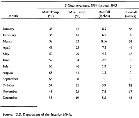
Table 2-1. Crater Lake National Park Weather Statistics.
Water Resources
Crater Lake is the dominant water feature and is the park’s primary water resource. Crater Lake is known for its deep blue color, which results from the lake’s purity: the water contains almost no organic matter and few dissolved materials. The sun’s wavelengths of red, yellow, and green are absorbed at a certain depth, but wavelengths at the blue end of the visible light spectrum are reflected and scattered by water molecules, which produces the deep blue color. No streams flow into or out of Crater Lake. The lake’s water comes only from snow, rain, and a few springs. Water is lost only through evaporation and seepage. The lake level seldom varies more than 3 feet even in the wettest years (Sierra Club 1985).
There are several creeks located in the western and southern part of Crater Lake National Park. These include Castle, Annie, Sun, Wheeler, and Sand Creeks (see Figure 1-2). Creeks within the park are known for their pristine quality and provide important wildlife habitat.
Air Quality
Crater Lake National Park has near pristine air quality and is classified as a Class I area as defined in the Federal Clean Air Act. Class I areas are those for which maintenance of air quality is critical for protection of the resource. All national parks and national wilderness and recreation areas are Class I areas. One factor that contributes to the clean air in Crater Lake National Park is that there are no significant upwind stationary emission sources. Industrial emissions from the Medford and Klamath Falls areas are carried south/southwest by the prevailing winds. (Lynn pers. comm.)