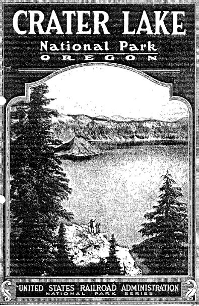


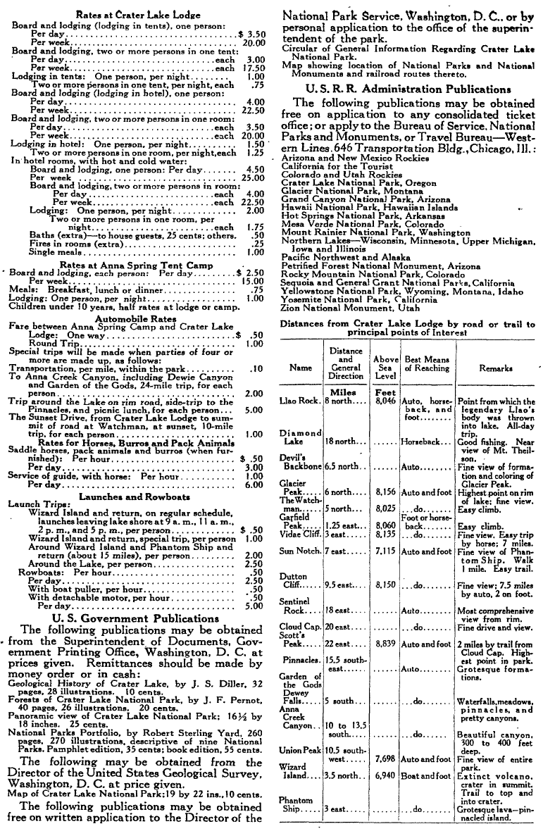
cover Crater Lake Railroad
An Appreciation of Crater Lake National Park
 |
|
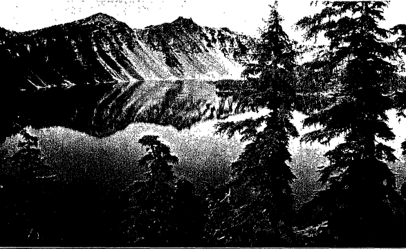
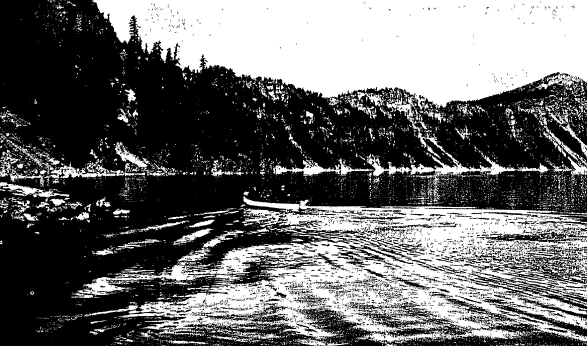
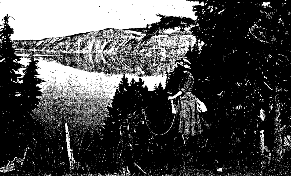
Reflections stand out distinctly in water that gleams as though glazed by the sun |
 |
|
Looking ‘Over the Top” |
An Appreciation of
Crater Lake National Park
By WINSTON CHURCHILL, Author of “The Crisis,” “Richard Carvel,” “The Crossing,” etc.
Written Especially for the United States Railroad Administration
IT IS not so many years ago that I left San Francisco with a case of rods, bound for Crater Lake in Oregon. What I had heard about the place had filled ‘me with awe and expectation, tempered by a little skepticism. I was personally conducted by patriotic and hospitable Oregonians who met me in sight of the fountains of Klamath, put me in a motor car and sped me northward through great forests and across wide prairies which once, not long since, had been an almost inaccessible wilderness. The immensity of the extinct volcano whither we were bound, that in prehistoric times had strewn the entire countryside with powdered stone, was hard to grasp.
It was July. We climbed the wooded slopes to the snows, forged through he melting drifts to the very lip of the crater and suddenly looked down upon a scene celebrated in Indian myth, and unique in all America. Some thousand feet below us lay a bottomless crystal lake, six miles across dotted with black volcanic islands. My delight in the grandeur of this view, it must be confessed, was heightened by the knowledge that the lake was inhabited by large rainbow trout which would rise to the fly. After leaving our bags in one of the comfortable tents which the government provides, and eating a hurried lunch in the big dining room, we took our rods and started down the trail. It is quite safe, but new in the experience of a sportsman from the East; and I took the snow slopes gingerly, put to shame by a twelve-year-old daughter of Oregon who romped down ahead of me, careless of the precipice below. And when at last we were afloat, one recalled the Indian legend that he who attempts to swim in this water is never heard of again. The boat was gliding-over nothing. The water was as clear as air. Leaning dizzily over the side of the boat, we saw the walls of the crater going down and down into the bowels of the earth, and rainbow trout gliding below us, apparently, in a medium like air. Above us the walls seemed to reach to the sky itself. But presently, when we had begun to fish, the clouds gathered and shut out the sky, in the midst of the summer afternoon darkness set in, thunder rolled and lightning played. It was a scene comparable only to something imagined by Dante in his Inferno.
The rain pelted down, the lake grew white-but the fish rose. Trout after trout took the flies, and when the sky cleared our arms were tired from playing them. The sun was setting. I made one last cast, near a bleak island, with a brown hackle. It was followed by that indescribable sensation of pure joy when a great fish gurgles on the surface, when the fisherman feels the first frantic tug and hears the singing of the reel. My rod weighed four ounces, and the trout at least eight pounds. He leaped, and leaped again. Twilight came on. For half an hour I played him, reeling him up to the boat only to see him rush away again: it became a question of staying down all night in the crater-or leaving him, since at night we could not have traced the trail. Reluctantly I left him. For when I tried to drown him by towing he snapped the leader and was free.
We had all the fish we cared to carry up the steep slope. But many times since I have thought of that trout, and I have never abandoned my intention’ to go back to Crater Lake some day and get him.
|
To the American People: Uncle Sam asks you to be his guest. He has prepared for you the choice places of this continent-places of grandeur, beauty and of wonder. He has built roads through the deep-cut canyons and beside happy streams, which will carry you into these places in comfort, and has provided lodgings and food in the most distant and inaccessible places that you might enjoy yourself and realize as little as possible the rigors of the pioneer traveler’s life. These are for you. They are the playgrounds of the people. To see them is to make more hearty your affection and admiration for America
Secretary of the Interior |

Crater Lake National Park
CRATER LAKE National Park is in southwestern Oregon, on the crest of the Cascade Range, sixty miles north of the California line, midway between San Francisco and Portland. It contains 249 square miles. The elevation varies from 5,000 to 9,000 feet above sea level. The Park is a broad and timbered plateau surmounted by numerous volcanic peaks, among them Scott Peak, Timber Crater, Desert Cone, Red Cone, Crater Peak and Union Peak. Crater Lake, weird- and mysterious, lies in their midst near the center of the Park, and is, as its name implies, a lake in the extinct crater of a volcano. It was not discovered by white men until 1853, and today is recognized as one of the greatest of scenic and most striking of geologic spectacles.
All of our great national playgrounds have their distinctive beauties; each is different in great measure in the sublimity and attractiveness of its natural grandeur, but Crater Lake stands alone in this: that all likeness to any familiar landscape here ceases.
Other lands have their crater lakes -Italy, India and Hawaii-and there are some craters in this country that contain miniature lakes; but there is only one really great caldera of this kind in the world-only one immense basin apparently formed through the complete melting by intense heat of the entire core of a great volcano, and the falling in and utter disappearance through subterranean caverns of its massive bulk.
That perpetual desolation – the nightmare of a Dante-should follow such a cataclysm would be expected; that aeons of time and the mystical workings of Nature have transformed the devastation to a dream-picture, will be a continual boon to the sightseer.
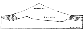
The titanic convulsion that formed this remarkable beauty-spot no human eye witnessed. Geologists have concluded that ages ago, in the great chain of volcanic mountain peaks which today extends from Washington to California-among them Mt. Rainier, Mt. Hood, Mt. Adams, Mt. Jefferson, Three Sisters, Mt. McLoughlin, Mt. Shasta and Lassen Peak-there towered one, which has been called Mount Mazama, that may have topped the tallest of its fellows. Judging from the pitch of the remnants of its outer slopes, scientists conclude with reasonable certainty that, if reconstructed, its snowclad peak would rise from seven to eight thousand feet above its broken rim. Mazama stands today an uncrowned king, shorn of its diadem of burning gold and glittering silver, yet holding within its heart a treasure the rarest in the world-a beautiful lake, the deepest of all lakes, with waters the bluest of all blue waters. And this is Crater Lake!
 |
|
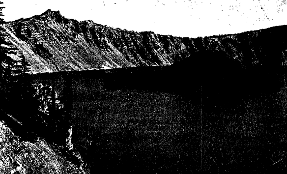
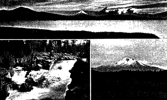
Mount Mazama if reconstructed |
Crater Lake is almost circular, varying from five to six miles in diameter. Its known depth is 2,000 feet and it is believed to be the deepest body of fresh water in the world. Its surface is 6,177 feet above the sea. It has no inlet or outlet, being fed by springs and winter snows; its water escapes by underground channels, reappearing as springs in the Klamath region, a few miles away. It is completely girdled by precipitous cliffs and steep talus slopes that fall sharply downward from its rim 2,000 to 600 feet to the water’s edge. Closely encircling it rise many high peaks, notably Llao Rock, The Watchman, and Cloud Cap; also Glacier, Garfield and Vidae Peaks.
The Discovery of Crater Lake
Surrounded by canyons, ravines and pinnacled rocks, and belted by a wilderness of boulder-strewn forests, the region for years was inaccessible, and unexplored except by the more venturesome who were attracted by stories of the Indians of this mystery lake in its fantastic setting. Yet its discovery was accidental; it occurred in 1853 while an exploring party was searching in the Cascade Mountains for the famous Lost Cabin Mine. The mine they did not find, nor has it ever been found, but instead they came upon this beautiful lake in the crater.
“Suddenly we came in sight of water,” writes J. W. Hillman, the leader of the party. “We were much surprised, as we did not expect to see any lakes, and did not know but that we had come in sight of and close to Klamath Lake. Not till my mule stopped within a few feet of the rim of the lake did I look down, and if I had been riding a blind mule I firmly believe I would have ridden over the edge to death.”
A dispute arose over the choice of a name, the party dividing between Mysterious Lake and Deep Blue Lake.
 |
|
Motorboating and fishing in the heart of an extinct volcano is novel sport |
The advocates of Deep Blue Lake won the vote, but in 1869 a visiting party renamed it Crater Lake, and this by natural right became its title.
First View of Crater Lake and Its Brilliant Coloring
The first sight of Crater Lake is wellnigh bewildering. Unless looked into from the rim it is invisible. Wonderment at the height and steepness of its encircling cliffs succeeds the first astonishment; admiration of the loveliness of its coloring next enthralls the beholder in the sequence of impressions. Its unique -beauty lies in no small measure in its coloring, the brilliance of which if reproduced in painting or print would seem exaggerated and impossible to those who have not seen the reality. Nowhere else is there such an azure. One feels that a glass of its water would show blue as if stained with cobalt, but it is clear as crystal and as pure. The deeper parts are a brilliant ultramarine, shading to turquoise in the shallower reaches, and to light jade green in the few indented coves around the shore. A hundred feet down the glaze of a plate is plainly discernible. The surroundings help the brilliance of the blue; the rocks are of metallic hues; the peaks of the rim are often snow covered; the lava gray of the steep scarred walls is mottled and splotched -with bright yellows and reds, markings left by volcanic action long ago, and always there is the dark green of the pines and firs and shrubs that grow on these declivities wherever they find root-hold. The waters are usually placid, gleaming as though glazed by the sun, and in this mirror of Nature the reflections stand out with astounding distinctness.
Of this feature of Crater Lake, Joaquin. Miller wrote: “Fancy a sea of sapphire set about by a compact circle of the grizzly rock of Yosemite. It is great, great; but it takes you days to see how great. It lies 2,000 feet under you, and as it reflects its walls so perfectly that you cannot tell the wall from the reflection, in the intensely blue water, you have a continuous unbroken circular wall of twenty-four miles to contemplate at a glance, all of which lies 2,000 feet, and seems to lie 4,000 feet, below. Yet so bright, so intensely blue is the lake that it seems at times, from some points of view, to lift right in your face.”,
 |
|
Wizard Island-A crater within a crater |
The Legend of the Indians
According to the legend of the Klamaths and Modocs the mystic land of Gaywas was the domain of the powerful demon Llao, whose throne was on Llao Rock. His warriors were gigantic crawfish which swarmed the lake, and with their great claws seized all who dared to appear on the cliffs above. The spirit chieftain Skell, of the neighboring Klamath Marshes, waged bitter war against Llao, but Skell eventually was captured, and his heart, torn from his body, was given by Llao to his minions who used it as a ball, hurling it from cliff to cliff with their claws.
One of Skell’s watchful eagles suddenly swooped down and caught the heart in mid-air, passing it to a fleetfooted antelope, which carried it to safety. Then miraculously the body of Skell grew about his heart, and he again waged war against his enemy. He captured Llao and upon the highest cliff cut his body into quarters, which he cast into the lake where they were eaten by Llao’s monsters under the belief that it was Skell’s body. But when Llao’s head was thrown in they recognized it and would not eat it. So Llao’s head still lies in the lake and white men call it Wizard Island, one of the small islands that rise from its depths today. The Indians, even today, look upon the face of Crater Lake with uneasiness and awe.
Wizard Island
The geological history of Wizard Island is fully as remarkable as that ascribed to it by the Indian legend. It was built up from the floor of Mount Mazama’s crater by expiring volcanic forces, and is today a perfectly preserved cinder zone rising 800 feet above the surface of the lake. It lies close to the cliffs on the western shore of the lake, and its appearance, when looked down upon from the rim, is one of the curious sights that fill the beholder with wonder. Soundings show that several other peaks of like nature rise froin great depths in the lake but do not come within some hundred feet of the surface, forming a submerged range of miniature crater mountains. A trail has been built to the edge of Wizard Island’s crater, which is 500 feet across the top and 100 feet deep; a trail also leads to the bottom. The western half of Wizard Island is a rough lava bed, and in one of its hollows is a dark pool known as the Witch’s Cauldron. Thus Wizard Island is doubly remarkable, being in fact a crater within a crater and containing a pool within a lake. Skell Channel separates Wizard Island from the mainland. The lake’s superb reflections are seen to fine advantage from the island.
The Phantom Ship
The picturesque Phantom Ship lies near the southern shore of the lake a few rods from the base of Dutton Cliff. It is a high craggy up-thrust of curiously sculptured lava; a mass of bronze and yellow spires and turrets showing almost a goblin fantasy of construction. At a distance its outline resembles a sailing ship-hence its name. The illusion at dusk or in the moonlight is striking. Approaching it in certain slants of light the Phantom Ship, when seen against the corrugated background of Dutton Cliff, suddenly disappears and is exceedingly difficult to again “pick up”-a- phantom ship indeed, in which the Ancient Mariner might well delight.
 |
|
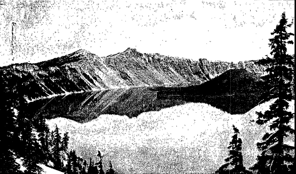
Panorama of encircling shores |
Trail from Crater Lake Lodge to Eagle Cove
A new trail of very easy grade has been constructed, leading from the rim at Crater Lake Lodge to the water at Eagle Cove, a descent of about 1,000 feet and a little over a mile in distance. Horses and burros can be used if desired, but the low grading of the trail makes the walk delightful, the accessibility of the lake adding greatly to the enjoyment of visitors. This charming walk, zigzagging in easy stretches down the heavily timbered slope, contrasts strangely with the belief expressed by the party of explorers who discovered the lake, that “its shore-line would never be touched by the foot of man.” But when you consider that an eighteen-foot launch crossing the lake is harder to “spot” than an aeroplane flying 3,000 feet overhead, and that a rowboat is undiscernible, some idea may be had of the beliefs and disbeliefs that Crater Lake readily suggests.
Unusual Fishing; Motorboats and Rowboats
The cold and crystal-clear water of Crater Lake originally contained no fish of any kind except a species of small crawfish.
In 1888, Mr. William G. Steel, now U. S. Commissioner for the Park, was the first to stock the waters with trout, but no fish were seen in the lake for twelve years; then a few were taken, one measuring 30 inches. Since then trout of the gamiest have been caught in ever-increasing numbers; preferably by flycasting from vantage points along the shore, and also by trolling with ‘spoon from rowboats. Fish weighing five and ten pounds are frequently caught.
In Crater Lake, five fish per person a day, and in all other waters in the park twenty fish per person, is the limit. There is good fishing in Anna Creek below Dewie Falls, as well as in neighboring streams. The fishing season is from July 1st to September 30th, unless otherwise ordered by the Superintendent of the Park. No license is required.
Launch Trips-A Cruise Around the Lake
At Eagle Cove, motorboats and row t oats are provided for boating or fishing parties; guides are also available for those who desire them.
Trips to Wizard Island are made by launch on regular schedules daily, and special trips can be arranged for, by the hour, skirting the Phantom Ship and nearby cliffs.
The striking features of the crater’s rim can best be seen by making a circuit of the lake along its edge. It reveals in a thousand changes the twisted and contorted lava formations, and is a moving picture of twentyfive miles of nature’s weirdest film.- This close-up view of the aftermath of Mazama will never be forgotten.
From Eagle Cove the launch heads east, rounding Eagle Point, with Garfield Peak towering high overhead; then crosses Chaski Bay, where Vidae Cliff rises 2,000 feet above. Just beyond, Dutton Cliff looks from its dizzy height on the Phantom Ship, the launch skirting its sculptured sides with its maze of lava rigging. Kerr Notch, just beyond Dutton Cliff, on Danger Bay, is the lowest point on the crater rim, 600 feet above the water. Sentinel Rock is the next peak outstanding on the wall above, and then follows Cloud Cap, 2,070 feet above the shore. Skell Head, suggesting Indian legends, appears on the southern point of Grotto Cove, where is seen The Wineglass, high on its northern cliff, a strange rock-slide shaped like a huge goblet and tinted as with winestain. Round Top, the Palisades and Rugged Crest are passed along the northeast shore, and below Rugged Crest is Cleetwood Cove, where the last great lava flow occurred.
But what strange sights have been unfolded in this half-circuit of the lake! Where can their like be seen? Contorted, twisted shapes-the deformity of nature in its every phase. Dark caverns piercing flamescorched walls that over-hang in jagged masses streaked with charred reds and sulphur-yellows; gorges packed with winter snows that- gleam like diamonds in jet settings-snows unmelted since their fall, with solid ice foundations, for sunshine has never reached their rock-bound depths. And all around them is the bright green glaze of needled pine boughs, drooping and waving in the breeze from trunks that slant at every angle-the growth of centuries. Surely Nature, to sooth Mazama’s wrath, has beautified its scars with dressings most sublime.
Rounding Pumice Point the launch glides into Steel Bay and then skirts Llao Rock, one of the most striking summits on the rim. just north of Llao Rock is a mile of desolation, The Devil’s Backbone, carved and ridged and lacerated as though by the whips of demons. Eagles soar and pelicans flap from rock to rock, and over all shines the brilliant summer sunshine from an azure sky that is reflected and thrown back from Crater Lake’s profound depths in an ultra-blue that challenges the heavens. Approaching Skell Channel, Glacier Peak looms high above the rim and The Watchman rears over Wizard Island’s cinder cone surrounded by its arm-shaped lava flows and rising like an octopus from the waters. The high-pitched roofs and gray walls of Crater Lake Lodge appear as a dot above, as the launch heads for Eagle Cove, and one of the most singular and spectacular of boat trips is ended.
The Rim Road-A Skyline Boulevard
The Rim Road entirely encircles Crater Lake a distance of 35 miles, winding around the base of the chain of peaks and crags that hedge its outer slopes; it is unique among skyline drives. From Cloud Cap on the eastern shore to The Watchman on the western side of the lake, a distance of 2 1 miles, it is in good condition. The remaining 14 miles connecting Cloud Cap with The Watchman, around the northern end of the lake, is being improved and surfaced. This work is progressing rapidly and the expectation is that the road will be open, except possibly for short periods, the present year. In this circular tour the vistas of the lake are everywhere superb and the surrounding mountain views are seen to excellent advantage.
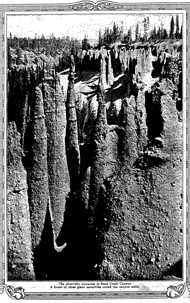
The Pinnacles-Sand Creek Canyon
The Pinnacles are reached by following the Rim Road from Crater Lake Lodge for about ten miles, thence three miles down Sand Creek Canyon. Here stand a jumble of giant monoliths crowding the canyon sides, carved by the winds and the rains of centuries into fantastic forms. There are hundreds of these sharp pointed figures, some of them over 100 feet in height, rising like the wraiths of a forest turned to stone. By moonlight their gray ghost-like appearance borders on the uncanny.
{Below, this is not the photo in the original book.}
|
|
|
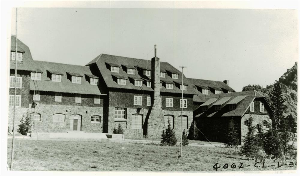
Crater Lake Lodge stands near the rim and overlooking the Lake. |
Dewie Canyon and Garden of the Gods
From Anna Spring Camp, five miles south of Crater Lake Lodge, the road leads eastward a few miles along the northern wall of Dewie Canyon, a timbered gorge cut out of the solid rock, its sides a silent testimony of its violent formation. At the head of the canyon are Dewie Falls, foaming cataracts which give the canyon its name, Dewie being an Indian word signifying falling waters. And here lies another Garden of the Gods, with its picturesque crags and towering pines, and meadows set about with paint brush, lupines and anemones.
Anna Creek Canyon
From twelve to fifteen miles south of The Lodge, on the Fort Klamath Road, the drive for eight miles overlooks Anna Creek Canyon, with many fine views three or four hundred feet into its depths. The canyon displays the curious columns and other grotesque forms characteristic of this entire volcanic region, though each of these picture gorges is distinctive in some new shuffling of Mazama’s magic deck.
Easy Mountaineering
Crater Lake National Park offers the mountain climber a novel field and many heights, some of which can be reached without great exertion; good horse trails and roads available for autos lead to several prominent summits. Union Peak and Scott Peak are perhaps the most remarkable. Union Peak, 7,698 feet above sea level, is about ten miles southwest of Crater Lake Lodge, and can be reached by saddle animals to within a quarter of a mile of its conical top. The last 700 feet is very steep, but the footing is secure. Unlike most of the mountains in this region, Union Peak is not a cinder cone, but the solid core of an ancient volcano. The view embraces the entire park The trail to Bald Top extends beyond Union Peak three miles, but it is very rough and steep. Scott Peak, 8,938 feet, is to the east, twenty-two miles from Crater Lake Lodge, and rises 700 feet above any other point in the vicinity of Crater Lake It is reached by auto to Cloud Cap, thence two miles by foot trail. There is an excellent trail to the to s of Garfield Peak, 8,060 feet, one and a quarter miles east of The Lodge. It can be made by foot or saddle animal. From its summit, which overlooks the lake, can be seen the Klamath Lake region to the south and the green valley of the Wood River. The lofty snow-capped peaks of Mt. McLoughlin and Mt. Shasta loom beyond. Mount Thielson, 9,178 ‘feet, and Diamond Lake are seen to the north of Crater Lake, a region which it is proposed to include in a Greater Crater Lake National Park.
The Watchman, five miles north of The Lodge, and Glacier Peak, 8,156 feet, six miles north and the highest peak on the rim, are on the east side of the lake, and each is reached by auto and easy foot trails. Vidae Cliff, on the rim, rises three miles east of The Lodge, and has a good horse trail to the top, distance seven miles.
A complete list of the principal points of interest, with heights and distances, is shown on another page.
 |
|
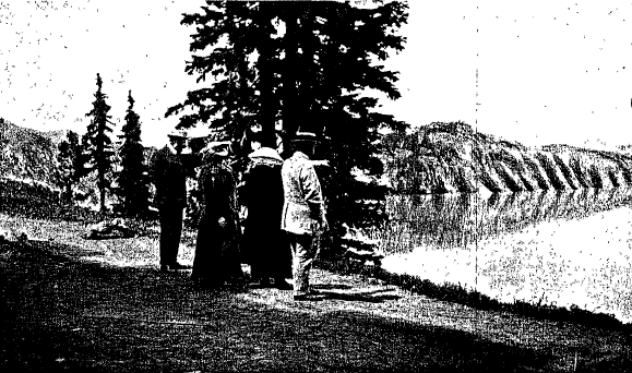
Horse trails lead to mountain heights and to many vantage points upon the rim. |
Wild Animals and Game
The Park abounds in black and brown bear, black-tail deer, pine marten, porcupine; also grouse, pheasants and numerous varieties of birds. Deer and bear are more plentiful each year and are becoming quite tame. Firearms in the Park are not permitted. Cougar, lynx, timber wolves and coyotes are seen occasionally and are being exterminated by the ranger force.
Scenic Approaches to Crater Lake by’ Medford and by Klamath Falls
The approaches to Crater Lake National Park are from the railroad stations of Medford, Ore., and Klamath Falls, Ore. The distance from Medford by auto is 81 miles; from Klamath Falls 62 miles, and these approaches constitute no little charm of the Crater Lake trip, for each drive traverses a country of much diversity in scenic attractiveness.
Crater Lake affords a most interesting side trip for tourists to or from California.
THE MEDFORD APPROACH: From Medford, the chief city of the Rogue River Valley, the auto road leads northeastward through miles of orchard country. Gradually the highway climbs out of the valley into the wooded foothills and as it leads up the gorge of the Rogue River the scenery takes on a wilder aspect. Among anglers the fast flowing Rogue is noted for its hard-fighting steelhead and rainbow trout. The river here runs like a thief and twists like a rogue, but its waters are white with rapids, the name being derived from its ruddy bed and given it by those French Canadian voyageurs-the Riviere Rouge, or red river,
Higher up the canyon, in the deepest wilderness, thunder the great Falls of the Rogue and farther up its course the river is spanned by a natural bridge of lava, a hundred feet across. At Rogue-Elk, thirty-six miles from Medford, lunch is served, and the drive is resumed, passing through the greatest forest of yellow pine in the world, with many firs, yews, larches and cedars. Climbing into the Cascades the view covers far-reaching vistas of densely wooded heights. As the road leaves the Rogue River it turns eastward up the canyon of Castle Creek and crosses the western boundary of the Park. Ahead is a cluster of sloping peaks, rising 1,000 feet above the general level of the range, and as the road winds upward to the crest below like a glittering jewel in a sunken setting lies Crater Lake.
THE KLAMATH FALLS APPROACH:
Klamath Falls is the center of the “Klamath Country” and is situated on the banks of the Link River, about a mile from Upper Klamath Lake. It is in a region full of the charm of mountain and forest, much of it still a wilderness-a fitting gateway for Crater Lake National Park. Its marshes are breeding-grounds for wild fowl; its clear streams are full of fighting trout; in its forests roam deer, bear and cougars, Crystal River, Cherry Creek, Wood River, Odessa Creek, Williamson River, Spring Creek and Sprague River are a few of the trout streams, well known to anglers, that enter the upper lake. Pelican Bay is a favorite trolling ground.
The auto road leads for eighteen miles along the shores of Upper Klamath Lake, the home of the white pelican. The lake is twenty-five miles in length and ten miles at its greatest width. The snow-capped peak of Mount McLoughlin rises 6,000 feet above its western shore, which shows tier upon tier of heavily timbered ridges that hem the horizon. Passing through the Klamath Indian Agency at the head of the lake, the road five miles further runs through Fort Klamath, both lying in a broad valley, surrounded by wooded foothills. As the grade ascends, the view looking back is a revelation in landscape loveliness. Winding upward through heavier timber it follows Anna Creek Canyon to Anna Springs Camp at the Park headquarters, thence five miles to Crater Lake Lodge on the rim.
 |
|
Mount McLaughlin rears to the west on the Upper Klamath Lake on The Falls of the Rogue River on the Medford road. Mount Shasta looms to the south on the Klamath Falls road. |
Accommodations Within the Park
CRATER LAKE LODGE: This attractive hotel constructed mainly of gray stone stands in the pines directly on the southeastern rim overlooking the lake, 1,000 feet above the water. It contains sixty-four rooms and affords comfortable accommodations and good service. It has ample bathing facilities and fire protection. Around the large open fireplace in its lobby visitors each evening recount their day’s experiences, and anglers unreel their tales of the fish they caught, and of the fish that got away.
Tents are provided, on request, for those who prefer them, meals being taken at The Lodge. There are many inviting spots on flower dotted meadows around the lodge, where beneath the pines on shaded slopes are snowbanks, with bright snow-flowers peeping through their melting edges.
ANNA SPRING CAMP: At the park headquarters, at Anna Spring, five miles south of Crater Lake Lodge, a good camp is maintained. The spring gushes from the mountainside at the head of Anna Creek. There is a general store here (with branch at The Lodge) where necessary supplies are obtainable. | Medford road, and rises above the shore of the Klamath Falls road.
Season
The 1919 season of Crater Lake National Park extends from July 1st to September 30th.
Park Administration
Crater Lake National Park is under the jurisdiction of the Director, National Park Service, Department of the Interior, Washington, D. C. The Park Superintendent is located at Crater Lake, Ore.
How to Reach Crater Lake National Park
Crater Lake National Park is connected by automobile stages of the Crater Lake Company with the railroad stations at Medford, Ore., and Klamath Falls, Ore.
During the Park season, round-trip excursion tickets at reduced fares are sold at many stations in California and Oregon to Crater Lake National Park as a destination. Passengers wishing to visit the Park as a side-trip in connection with journeys to other destinations will find stop-over privileges available on through round-trip and one-way tickets, and may, if they choose, enter the Park via Medford and leave via Klamath Falls, or the reverse.
Storage charges on baggage will be waived at railroad stations at Medford, Klamath Falls or Weed, or at Portland. or at Sacramento, Oakland Pier, San Francisco or Los Angeles, for actual length of time consumed by passengers in making the Crater Lake trip.
Automobile-Stage Rates
The Crater Lake Co. will operate regular daily automobile service from Medford. and Klamath Falls. Oregon, to and from Crater Lake National Park at the following rates:
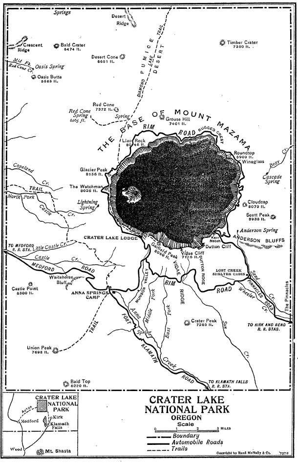
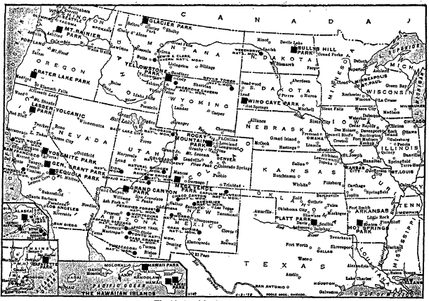
Crater Lake National Park Map
National Parks Map
Back Cover
 |
|
The ghost-like pinnacles in Sand Creek Canyon. A Forest of these giant monoliths crowd the canyon walls. |
Other pages in this section