
Clearing the Way
There are still some people who are surprised to learn that Crater Lake can be seen at any time of the year. Much of this misperception is due to visitors focusing on the North Entrance and associating its closure each year with the park being shut for the winter.
Since opening the North Entrance each year signifies the start of peak visitation, the casual observer might wonder why virtually all park facilities are situated on the south side of the caldera. One reason is that very little surface water exists on the north side of Crater Lake despite the prodigious snowfall. Efforts to develop a water supply were frustrated in the 1960s when contractors drilled wells at Cleetwood Cove and the North Entrance but netted nothing but air. A steep ascent from Pumice Desert to the North Junction, coupled with the difficulties of fighting prevailing wind from the southwest, make consistent plowing of the north road exceedingly difficult. Clearing the route leading to Rim Village from Annie Spring and Highway 62 is, by comparison, much easier.
Most visitors come to Crater Lake only during the summer months and are oblivious to the complexities associated with snow removal. Many of them see only a few outward manifestations of winter, such as snow tunnels attached to buildings at Park Headquarters. The size and number of plows operated by park crews are usually out of sight by this time, along with the multitude of snow poles which line certain roads for most of the year.
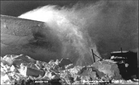
Rotary snow plow used in the late 1930s.
Prior to 1930, when the first rotary snow plow arrived at Crater Lake, opening any road to the rim each spring required a large crew armed with shovels. They began by chopping through most of the previous winter’s snowpack to reach the road surface, which was often under many feet of snow even in June. Warm weather and the high sun angle of late spring might eventually allow for cars to reach Rim Village in early July, but the park’s operating season was effectively reduced to three months or less. With machines which could throw snow away from the road surface, and then above surrounding banks of ten feet or more, it became possible to keep a few roads open throughout the year.
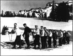 Skiers at Rim Village in 1957. NPS photo by Raymond K. Rundell. |
As might be expected, rotary snow plows gave winter use in the park a decided shot in the arm. Such use had amounted to virtually nil before that time except for the occasional venturesome skier coming from Fort Klamath, the closest permanent settlement. Improving economic conditions by the late 1930s gave rise to increased travel and an associated demand for winter sports. No permanent facilities for downhill skiing were ever constructed, but Crater Lake was listed as Oregon’s second biggest winter sports area (behind Mount Hood) in 1940. That status has to be understood in the context that most leases for development of areas on Forest Service land, such as on Mount Bachelor near Bend, were not issued until the explosion in leisure travel had occurred after World War II.
Wartime restrictions on travel meant closure for Crater Lake National Park from 1942 to 1945. When the park reopened, there was uncertainty concerning whether to provide downhill skiing facilities. National Park Service planners studied several locations such as Applegate Peak, Arant Point, and the west side of Munson Ridge in 1948, but concluded that any new development aimed at downhill skiing carried far more long-term costs than benefits. They recognized, however, that existing use (visitors wanting to see the lake in winter, as well as cross country skiing and snowshoeing) as justification for keeping the park open all year round. This has occurred over the past 50 years by plowing snow as it accumulated on roughly 25 miles of park roads.
Those visitors and employees who utilize the access provided by the snow plows have the opportunity to enjoy the beauty brought to the rim of Crater Lake by each seasonal change. During the long winter, the snow accentuates glassy blue or steel grey of Crater Lake depending on clear or cloudy conditions. Visitors often note the snowdrifts, especially where the wind puts vast deposits in some places (upwards of 60 feet at the Watchman) but scours bare spots in others.
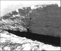 Roadside snow depth. |
As the snowpack begins to recede in May, the patches of bare ground slowly widen and eventually become host to a variety of plants and animals. Flower displays herald the arrival of spring sometime in late June, though the peak bloom will not be reached until the first week of August. At that time motorists and hikers alike are quick to note bright colors and ask for the names of certain wildflowers.
The summer heat usually melts even the most persistent patches of snow by mid August so that all roads and trails in the park are open. This is when the ubiquitous Newberry knotweed(Polygonum newberryi) turns from green to red in the vast pumice fields along the rim drive. Fortunate visitors may also find that yellow-bellied marmots (Marmota flaviventris) and pikas (Ochotona princeps) show themselves on talus slopes or even near the road.
Sometime during the first half of September, the first crisp air indicates the onset of autumn. By the end of the month, the leaves of shrubs such as mountain ash (Sorbus sitchensis) have turned color in a matter of only several days. They provide memorable splashes of red and yellow to those visitors lucky enough to be in the park at that time, and perhaps portend a few weeks of Indian Summer. On October 20th, however, there is a 50 percent chance of the first significant snowfall–one which will close most roads and the North Entrance. When that storm arrives, it heralds the onset of winter and the prospect of nearly nine months with snow on the ground. This is also when the snow plows return to clear the way to the rim of Crater Lake.
Steve Mark has worked as park historian at Crater Lake and Oregon Caves since 1988.