11—Cleetwood very gravelly ashy loamy coarse sand, depressional, 0 to 7 percent slopes Map Unit Setting General location: Depressional areas in Pumice Desert Major land resource area (MLRA): 3 Elevation: 5,800 to 6,200 feet Average annual precipitation: 60 to 80 inches Average annual air temperature: 38 to 42 degrees F Frost-free period: 0 to 30 … Continue reading 24 11—Cleetwood very gravelly ashy loamy coarse sand, depressional, 0 to 7 percent slopes →
The Geology and Petrography of Crater Lake National Park, 1902 PART II. HYPERSTHENE-DACITES. DISTRIBUTION AND DESCRIPTION OF DACITE MASSES. CLEETWOOD COVE FLOW. This mass is one of the latest lava flows to be found on the rim of the crater. According to Mr. Diller a part of this stream was fluent at the time the … Continue reading 80 Cleatwood Cove Flow →
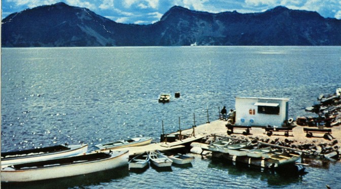
Cleetwood Cove Trail – Crater Lake National Park Time: 1 hour Difficulty: Strenuous Length: 1.1 mi (1.77 km) Elevation: 6175* – 6831 ft (1882* – 2082 m) Trailhead coordinates: Latitude: N +42° 58.78 or 42.934217 Longitude: W -122° 04.99 or -122.08320 Altitude: 6831 ft (2082 m) Highlight: swimming, fishing, boat tours; Access to lake … Continue reading Cleatwood Cove Trail →
Search exercise to cover area where boy was lost Herald and News Klamath Falls, Oregon September 11, 2009 Personnel to train at Crater Lake National Park this weekend CRATER LAKE NATIONAL PARK — Search and rescue personnel from throughout the region will train beginning this weekend at Crater Lake National Park, near the area … Continue reading Search exercise to cover area where boy was lost – September 11, 2009 →
NATIONAL PARK RECREATION Crater Lake will expand some openings in 2021 With the pandemic seeming to ease, some popular activities are expected to resume this year By Lee Juillerat for the Mail Tribune Some programs that were missing in 2020 because of the COVID-19 pandemic will be offered at Crater Lake National Park this summer, but … Continue reading 2021-3-27 Some things open, some not →
U.S. Geological Survey Scientific Investigations Map 2832 Version 1.0 Geologic Map of Mount Mazama and Crater Lake Caldera, Oregon By Charles R. Bacon Including the Database for the Geologic Map of Mount Mazama and Crater Lake Caldera, Oregon by David W. Ramsey, Dillon R. Dutton, and Charles R. Bacon 2008 Crater Lake – Wizard Island View from … Continue reading USGS 2008 Maps and Database – Ramsey, Dutton, Bacon →
This was the original boundary sign on the Pinnacles Road, just .5 miles east of the Pinnacles parking lot. The park boundary sign can be seen on the left bottom of the first photo. If used, please credit Larry Eifert, Crater Lake Institute. Below the boundary photos is the complete story of this important place … Continue reading The Original East Entrance →
Mail Tribune June 14, 2020 Sunday OUTDOOR RECREATION / TRAVEL Drawn by the Crater Nationwide vacationers began visiting Crater Lake National Park when it opened this week By Lee Juillerat for the Mail Tribune CRATER LAKE NATIONAL PARK — Jeff Cook came from Florida. Elsa Porcaro and her husband, daughter, father and three sisters … Continue reading 2020 – 06-10 Visitors began Visiting →
The United States Geologic Survey has a water level monitor on the lake near Cleatwood dock. It’s unmaintained in winter, but shows current and past water levels – a great resource. Video excerpted from the visitors center film “Crater Lake Into the Deep”. https://www.nps.gov/crla/learn/nature/craterlakelevel.htm Click below for current water levels. This takes you out of … Continue reading USGS Water Levels at Crater Lake →
***previous*** — ***next*** Crater Lake Fascinations: Diller’s pin, clear water, fish stories keep lake and park a place of wonder forever fascinating Herald and News Klamath Falls, Oregon?August 31, 2002 By LEE JUILLERAT Frequent visits to Crater Lake National Park constantly reveal new tidbits of information that help to keep the lake and park a … Continue reading Water Levels and Visitor Levels →