
Weather and Climate Inventory, Klamath Network, National Park Service, 2007
3.0. Methods
3.1. Metadata Retrieval
A key component of station inventories is determining the kinds of observations that have been conducted over time, by whom, and in what manner; when each type of observation began and ended; and whether these observations are still being conducted. Metadata about the observational process (Table 3.1) generally consist of a series of vignettes that apply to time intervals and, therefore, constitute a history rather than a single snapshot. An expanded list of relevant metadata fields for this inventory is provided in Appendix E. This report has relied on metadata records from three sources: (a) Western Regional Climate Center (WRCC), (b) NPS personnel, and (c) other knowledgeable personnel, such as state climate office staff.
The initial metadata sources for this report were stored at WRCC. This regional climate center (RCC) acts as a working repository of many western climate records, including the main networks outlined in this section. The WRCC conducts live and periodic data collection (ingests) from all major national and western weather/climate networks. These networks include the COOP network, the Surface Airways Observation network (SAO) operated by NWS and the Federal Aviation Administration (FAA), the interagency RAWS network, and various smaller networks. The WRCC is expanding its capability to ingest information from other networks as resources permit and usefulness dictates. This center has relied heavily on historic archives (in many cases supplemented with live ingests) to assess the quantity (not necessarily quality) of data available for NPS I&M network applications.
The primary source of metadata at WRCC is the Applied Climate Information System (ACIS), a joint effort among RCCs and other NOAA entities. Metadata for KLMN weather/climate stations identified from the ACIS database are available in file “KLMN_from_ACIS.tar.gz” (see Appendix F). Historic metadata pertaining to major climate- and weather-observing systems in the U.S. are stored in ACIS where metadata are linked to the observed data. A distributed system, ACIS is synchronized among the RCCs. Mainstream software is utilized, including Postgress, Python™, and Java™ programming languages; CORBA®-compliant network software; and industry-standard, nonproprietary hardware and software. Metadata and data for all major national climate and weather networks have been entered into the ACIS database. For this project, the available metadata from many smaller networks also have been entered but in most cases the actual data have not yet been entered. Data sets are in the NetCDF (Network Common Data Form) format, but the design allows for integration with legacy systems, including non-NetCDF files (used at WRCC) and additional metadata (added for this project). The ACIS also supports a suite of products to visualize or summarize data from these data sets. National climate-monitoring maps are updated daily using the ACIS data feed. The developmental phases of ACIS have utilized metadata supplied by the NCDC and NWS with many tens of thousands of entries, screened as well as possible for duplications, mistakes, and omissions.
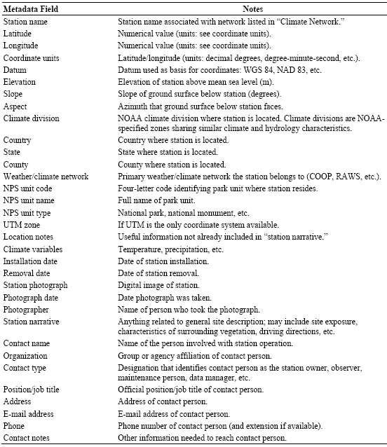
Table 3.1. Primary metadata fields for KLMN weather/climate stations. Explanations are provided as appropriate.
Two types of information have been used to complete the KLMN climate station inventory.
- Station inventories: Information about observational procedures, latitude/longitude, elevation, measured elements, measurement frequency, sensor types, exposures, ground cover and vegetation, data-processing details, network, purpose, and managing individual or agency, etc.
- Data inventories: Information about measured data values including completeness, seasonality, data gaps, representation of missing data, flagging systems, how special circumstances in the data record are denoted, etc.
This is not a straightforward process. Extensive searches are typically required to develop historic station and data inventories. Both types of inventories frequently contain information gaps and often rely on tacit and unrealistic assumptions. Sources of information for these inventories frequently are difficult to recover or are undocumented and unreliable. In many cases, the actual weather/climate data available from different sources are not linked directly to metadata records. To the extent that actual data can be acquired (rather than just metadata), it is possible to cross-check these records and perform additional assessments based on the amount and completeness of the data.
Certain types of weather/climate networks that possess any of the following attributes have not been considered for inclusion in the inventory:
- Private networks with proprietary access and/or inability to obtain or provide sufficient metadata.
- Private weather enthusiasts (often with high-quality data) whose metadata are not available and whose data are not readily accessible.
- Unofficial observers supplying data to the NWS (lack of access to current data and historic archives; lack of metadata).
- Networks having no available historic data.
- Networks having poor-quality metadata.
- Networks having poor access to metadata.
- Real-time networks having poor access to real-time data.
Previous inventory efforts at WRCC have shown that for the weather networks identified in the preceding list, in light of the need for quality data to track weather and climate, the resources required and difficulty encountered in obtaining metadata or data are prohibitively large.
***previous*** — ***next***