
Weather and Climate Inventory, Klamath Network, National Park Service, 2007
4.0. Station Inventory
4.2. Station Locations
The major weather/climate networks in the KLMN (discussed in Section 4.1) have at most several stations at or inside each park unit (Table 4.2). Most of these are COOP stations.
Table 4.2. Number of stations within or nearby KLMN park units. Numbers are listed by park unit and by weather/climate network. Figures in parentheses indicate the numbers of stations within park boundaries.
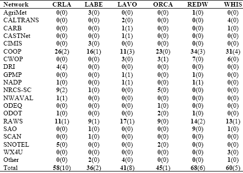
Network CRLA LABE LAVO ORCA REDW WHIS
Lists of stations have been compiled for the KLMN. As was mentioned previously, a station does not have to be within park boundaries to provide useful data and information regarding a given park unit. Some might be physically within the administrative or political boundaries, whereas others might be just outside, or even some distance away, but would be nearby in behavior and representativeness. What constitutes “useful” and “representative” are also significant questions, whose answers can vary according to application, type of element, period of record, procedural or methodological observation conventions, and the like.
Ten weather/climate stations were identified within the boundaries of CRLA (Table 4.3; Figure 4.1). Only one of these is inactive; this was a COOP station that operated on Crater Lake’s north rim from 1963 until 1976. The COOP station “Crater Lake” is located at Rim Village on the lake’s southern rim and provides the longest climate record in the park. This station has operated since 1919. With the exception of numerous gaps from 1943 through September 1946, this station has a very complete data record. Desert Research Institute (DRI) operates a few stations throughout the park unit; most of these stations started operating in 1999 or 2000. “Crater Lake Buoy” is located on Crater Lake itself. “Crater Lake USGS Gage” (1987-present) is situated at Cleetwood Cove along the north shore of the lake. The other two DRI stations are located in south CRLA. “Crater Lake Rim” is located at Rim Village, while “Crater Lake Lagoon” is near park headquarters. Two NRCS-SC sites are within CRLA; “Park H.Q. Rev.” is just southeast of Rim Village, while “Annie Spring Rev.” is 5 km south of Rim Village. The NWAVAL station “Crater Lake” is near Rim Village. The only RAWS station we identified within CRLA (Panhandle) is in the extreme southern portion of the park.
Table 4.3. Weather/climate stations for the KLMN park units. Stations inside park units and within 40 km of the park unit boundary are included. Missing entries are indicated by “M”.
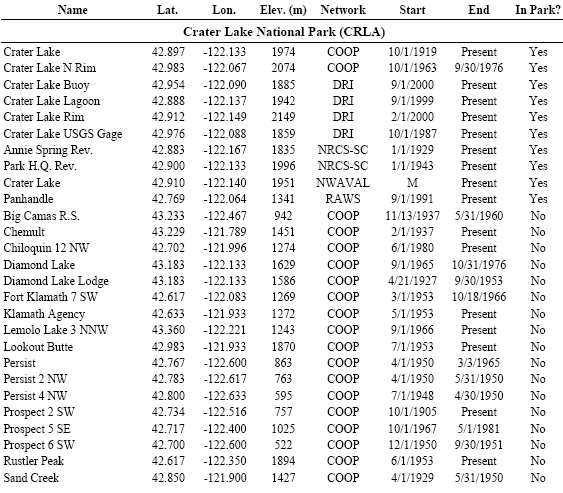
Of the 24 COOP stations we identified within 40 km of CRLA (Table 4.3), 10 are active. The COOP station “Prospect 2 SW” is located 22 km southwest of CRLA and provides the longest climate record in the area (1905-present).The data record at “Prospect 2 SW” is very complete. Another long-term record is available at the COOP station “Chemult,” 24 km northeast of CRLA. This station’s data record, which goes back to 1937, was very complete until 1980 but has had scattered data gaps since then. Several other active COOP stations within 40 km of CRLA have data records that go back to the 1950s.