
Status of Whitebark Pine in Crater Lake National Park, Oregon, 2000
METHODS
We inventoried survey transects within the whitebark pine zone of the Park (Figure 1). About half of the transect starting points and azimuths were not random because the pine’s distribution is sparse or restricted to small tree islands and the edge of craters where strict randomness would result in intersecting few pine individuals. Non-random transect starts were subjectively placed in central locations, that is surrounded by whitebark pine, ensuring a random azimuth would work. Non-random azimuths followed an elevational contour or the Rim Trail. At tree islands, a random island was usually chosen from which a random transect azimuth was followed. Often, these transects extended over meadows to other tree islands. Transects had variable widths depending on the density of whitebark pine trees. Widths ranged from 15 to 100 feet and lengths varied between 177 and 2,038 feet (Figure 1).
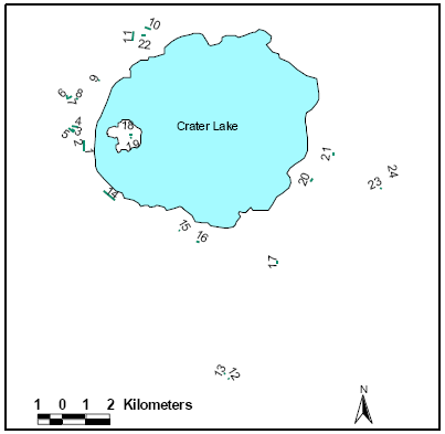 |
| Figure 1. Location of twenty-four inventory transects. |
The first fifty live and dead trees along a transect were measured for diameter, live crown ratio, canopy dominance, and damaging agents. Because whitebark pines often occur in clusters of same-aged individuals (former nutcracker seed caches), this was also noted. When a pine was determined to have blister rust, we recorded the percent of crown killed, canker distance to main stem, canker height above ground, and a rough estimate of the age of the most recent canker. Trees that had inactive or dead blister rust cankers were noted separately and not considered as infected, but resistant.
At every transect additional observations were noted. Dominant understory flora were identified and the abundance of currant shrubs (Ribes spp.) was described. The beginning and ending of each transect was georeferenced using a handheld global positioning system (gps) receiver. The slope and aspect were measured at each end of the transects.
***previous*** — ***next***