
The Geology and Petrography of Crater Lake National Park, 1902
PART I.
CASCADE RANGE.
FOUNDATION OF CASCADE RANGE.
A clearer conception of the development of the Cascade Range may be gained by considering the geography of the region during the later portion of the Cretaceous. At that time the coast of northern California, Oregon, and Washington was subsiding with reference to sea level, causing the sea to advance upon the land. In California the sea reached the western base of the Sierra Nevada and covered a large part, if not the whole, of the Klamath Mountains. In Washington it beat upon the western base of the range near the coast north of Mount Rainier, and in Oregon it extended far into the interior. Marine deposits of this period occur along the base of the Blue Mountains in eastern Oregon, as the Cascade Range did not then exist in Oregon to shut out the open sea from that region.
East of the Klamath Mountains, as shown by the position and distribution of the Cretaceous rocks and fossils of marine origin, the open sea connected directly with the sea in the Sacramento Valley. The Cascade Range throughout a large part of its extent rests upon Cretaceous rocks, and is associated in Oregon and California with a depression in the older rocks between the Klamath Mountains on the one hand and the Blue Mountains and Sierra Nevada on the other. This depressed area beneath the lavas of the Cascade Range must not be regarded primarily as a region of subsidence, as its chief movement since tine Cretaceous has been upward, above the sea. The Klamath and Blue Mountains, as well as the Sierra Nevada, however, have been elevated so much more than the base of the Cascade Range that it would appear on the surface as a depression were it not filled with lava. The depression is so deep where the Cascade Range is cut across by the Klamath and Columbia rivers that the bottom of the lavas forming the bulk of the range is not reached. However, at the ends of the range the older rocks rise to form a more or less elevated base for those parts of the range, and at Mount Shasta. as well as on the divide between the Rogue and Umpqua rivers where an arch of the older rocks extends northeasterly from the Klamath Mountains toward the Blue Mountains of eastern Oregon, the Cascade Range gets so close to the western side of the depression that the lavas lap up over the arch of older rocks rising to the westward. At various points of the range granolitic rocks, such as gabbro and diorite, occur; but the deep erosion at these points may have reached the granolites corresponding to the lavas of the upper portion of the range.
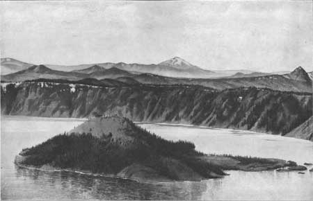
Plate II.—CONES ON SUMMIT PLATFORM OF CASCADE RANGE.
The sharp peak on the right is Union Peak; in the distance is Mount Pitt; in the foreground are Wizard Island and Crater Lake.