
The Geology and Petrography of Crater Lake National Park, 1902
PART I.
MOUNT MAZAMA.
LAVAS OF MOUNT MAZAMA.a
ANDESITES.
Andesites constitute by far the greater portion of the lavas of Mount Mazama. A rough estimate makes their volume at least ten times the combined volume of the dacites and basalts. They form almost the whole of the inner slope of the rim, where the overlapping sheets of successive flows appear in section in their order of eruption, from the earliest to the latest. Flows lying at a depth of nearly 2,000 feet beneath the mountain slope are seen, but a much larger amount of flows still deeper is unexposed.
Were it possible to remove the water of the lake, the thickness of the exposed lava would be nearly doubled, and there is no evidence to show that its character is very different from that which now outcrops by the water’s edge around the lake. However, at still greater depths there probably occur Tertiary and Cretaceous sediments resting on older rocks similar to those of the Klamath Mountains. Hornblende- and mica-andesites, which are commonly associated with the hypersthene-andesites of the great volcanic centers of the Cascade Range as, for example, Lassen Peak, Mount Shasta, and Mount Hood—have not been found in Mount Mazama. Traces of hornblende were observed in only two of the hypersthene-andesites collected; one of these is a massive sheet nearly 100 feet thick along the trail near the point where it begins the descent to the lake (44),a and the other is a gray lava (45) on the slope of Castle Crest.
aThe rock collection to which the numbers refer is in the National Museum, Washington, D.C.
The oldest flows exposed on the southwest side of the lake are represented by specimens Nos. 24, 61, 11, and 163. They are overlain by many streams which successively issued and spread from the summit or upper slopes of Mount Mazama. The flows vary greatly in size and number in different portions of the rim. In places as many as 30 superimposed layers, mixed with many beds of fragmental material, make up the wall of the rim. The largest number of flows exposed in one section occurs about Sun Creek Notch. Many flows are 30 to 40 feet in thickness. Under Castle Crest nearly a score appear in this steep slope, and they range from 30 to 80 feet in thickness. Between many of them are layers of volcanic conglomerate, which are usually thin, and, being softer, less prominent. In the western rim flows are not so numerous, and conglomerate was estimated to form about one-fourth as large a mass as the solid lava. More fragmental material appears to have accompanied the earlier than the later flows, and on the whole there is a larger proportion in the rim at the head of Anna Creek than elsewhere. In the East Palisade (Pl. VII, B) the thickest flow of andesite is well exposed. It is cut by many joints, reaches more than halfway from the water to the crest of the rim, and has a thickness of nearly 500 feet.
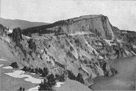
Plate VII—A. INNER SLOPE OF GLACIER PEAK.
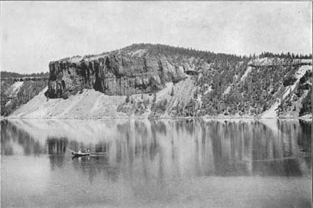
Plate VII—B. EAST PALISADE.
The thickness of any flow upon the mountain slope depended chiefly upon the amount of lava, its liquidity, and the inclination of the surface over which it flowed. Many of the sheets are uniformly thin. They follow the outer slope for considerable distance, and indicate a moderate supply of lava that flowed easily. Other flows, as that of the Palisades, filled valleys in the outer slope of Mount Mazama and varied greatly and abruptly in thickness, becoming very thin on their edges. The thickest of all the flows, however, is the great dacite flow of Llao Rock, which is over 1,200 feet thick over the middle of an old valley. The material was evidently very much less fluent than the andesites, for the flow, although thick, is short and narrow.
In distribution the andesites on the outer slope of the rim are divided into ten areas, and each may be designated by some contained feature, as The Watchman, Castle Creek, Munson Point, Union Peak, Eagle Crags, Dutton Cliff, Sentinel Rock, Round Top, Bear Creek, and Steel Bay. All these areas are practically joined by a complete ring of andesite exposed upon the inner slope of the rim of the lake. In addition to these areas around the rim is Wizard Island, which is also composed of andesite.
***previous*** — ***next***