
The Geology and Petrography of Crater Lake National Park, 1902
PART I.
CRATER LAKE.
CHANGES OF WATER LEVEL IN CRATER LAKE.
An examination of one of the embayed shores of Crater Lake in August or September will convince anyone that the lake changes level. Late in June a little crustacean, Daphnia pulex pulicaria, swarms along the shore and attracts other minute forms in abundance to the same place. A white deposit composed of the remains of these organisms marks the shore line at the upper limit of their abundant appearance, and as the season advances lower levels are marked in the same way. During the summer, when there is rapid evaporation and little or no precipitation, the surface of the lake subsides, but during the rainy winter it rises again. The oscillation is limited to about 4 feet. The rising and the sinking balance each other, so that the lake maintains in general nearly the same level. No observations whatever have been made when the water was at its highest stage, which is supposed to be early in May, but the lowest turning point was reached in 1901 about the 1st of October. The high and low points vary from year to year with the seasons, but the change is so gradual and on the whole so small that distinct beach levels are not developed. The lowest water known was observed September 26, 1893, when it was less than a foot below its level on September 15, 1901.
August 22, 1896, a gage was erected on the shore of Crater Lake, for the Mazamas, by C. H. Sholes, president, and Earl M. Wilbur, secretary. The gage was made of a board 5-3/4 inches wide and 10 feet long, with scale subdivided to tenths of a foot. It was nailed to a log extending from the shore into the water, and zero of the scale was placed just 4 feet beneath the water surface, thus allowing the water to sink 4 feet without leaving the scale. A copper pocket fastened to the upper part of the gage contained a record book, in which visitors at the lake were asked to note the height of the water. Fearing that this fragile gage might not escape accident from rolling stones or sliding snow, W. W. Nickerson, of Klamath Falls, was requested to insert a bolt in a cliff near the gage and carefully determine the height of the bolt above the water and read the gage. In the record book, September 25, 1896, Mr. Nickerson records the height of the water on the gage 3.425, and adds: “Also strengthened the gage, as requested by Messrs. Diller and Steel, and put up copper bolt 50 feet to the west of the gage at an elevation of 5.75 feet above the present level of the water.” The gage was broken off during the following winter and cast adrift on the lake.
August 13, 1901, James Storrs and Fred. Larsen, while making stream measurements, found the copper box containing the record book in 5 feet of water along the shore of Danger Bay, about 3-1/2 miles east of Eagle Cove, where the gage had been established. The records were well preserved in the book, notwithstanding the five years’ soaking, and enabled us to find Mr. Nickerson’s bolt and reestablish the Mazama gage level. We painted the scale shown in Pl. XIII, A, on a rock a short distance northwest of Nickerson’s bolt, and added a scale also on the rock containing the bolt, the rock at the last place being too rough for small divisions. The zero of these scales has the same level as that of the Mazama gage, and all known readings of the lake level have been reduced to that scale in the following table.
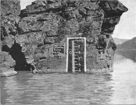
Plate XIII.—A. WATER GAGE, CRATER LAKE.
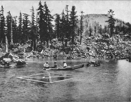
Plate XIII.—B. RAFT AND EVAPORATING PAN.
Water level of Crater Lake with reference to scale established by Mazamas, August 22, 1896.
| Date. | Height of water. |
Remarks. |
| Feet. | ||
| September 10, 1892 | 4.142 | Mr. F. V. Coville found “O. H. Herchberger, Sept. 10, 1892 ” painted on a detached bowlder a few yards west of boat landing, and reports that Aug. 1, 1897, “the lower end of the 9 was 7-1/2 inches beneath the surface of the lake.” |
| September 26, 1893 | 2.52 | Mr. F. V. Coville found “Dr. Kirchgessner, Heath Kirchgessner”apainted on a rock in place a few yards east of the landing, and reports that “the lower part of the H was 27 inches beneath the surface of the lake.” |
| August 22, 1896 | 4.00 | C. H. Sholes and Earl M. Wilbur, president and secretary of the Mazamas, Portland, Oreg., established for the society a wooden gage. Zero of the scale was 4 feet beneath the surface of the lake.a |
| August 30, 1896 | 3.90 | (The record 4.9 should evidently be 3.9, as the lake surface was sinking.) |
| September 4, 1896 | 3.825 | J. S. Diller observer. (Rate of fall a day for 13 days, 0.0135 foot.) |
| September 5, 1896 | 3.820 | E. B. Barrows, observer. |
| September 13,1896 | 3.500 | Thomas Croxton, observer. |
| September 25, 1896 | 3.425 | W. W. Nickerson, observer, who fixed bolt in rock west of gage and 9.175 feet above zero of Mazama scale. (Rate of fall a day for 34 days, 0.0169 foot.) |
| August 1, 1897 | 4.77 | F. V. Coville made a mark “3 ft.” on rock 250 yards east of foot of trail, and another “c” on a rock 60 yards west of trail. Zero of Coville’s scale=4.77 of the Mazama scale. The remnant of the old Mazama gage has subsided considerably since Mr. Coville’s observations. |
| July 1, 1901 | 4.905 | J. S. Diller observer. |
| July 20, 1901 | 4.613 | J. S. Diller observer. (Rate of fall a day for 19 days, 0.0155 foot.) |
| August 1, 1901 | 4.42 | E. W. Herchberger, observer. (Rate of fall a day for 12 days, 0.0158 foot.) |
| August 16, 1901 | 4.11 | E. W. Herchberger, observer. (Rate of fall a day for 15 days, 0.0266 foot.) |
| September 1,1901 | 3.92 | E. W. Herchberger, observer. (Rate of fall a day for 16 days, 0.0118 foot.) |
| September 15,1901 | 3.24 | E. W. Herchberger observer. (Rate of fall a day for 14 days, 0.0486 foot.) |
| October 12 1901 | 3.39 | E. W. Herchberger, observer. (Rate of rise a day for 29 days, 0.0051 foot.) |
| Average rate of fall from July 1 to September 15 (77 days), 0.0236 foot per day. aThese marks could not be found in July, 1901. |
||
Summary of fluctuations of Crater Lake.
| Period. | Number of days. |
Rate of subsidence. |
| 1896. | Foot. | |
| August 22 to September 4 | 13 | 0.0135 |
| September 4 to September 25 | 21 | .0190 |
| 1901. | ||
| July 1 to July 20 | 19 | .0155 |
| July 20 to September 15 | 58 | .0236 |
| Average for | 111 | .0179 |
At this rate in 365 days it would sink only 6.53 feet, i. e., 78 inches, which is much more than the annual precipitation. However, in this consideration it must be remembered that the rate of loss noted is entirely too great for the winter, when evaporation is much slower than in summer.
No positive evidence has been observed anywhere on the inner slope of the rim that the lake was ever considerably higher or lower than it is to-day. The complete absence of beach lines above those of the present level of the lake is conclusive that the lake never stood higher, but marks of any kind as to lower levels would be submerged. The shore line at many points is a steep bluff of rocks, but at many places, especially at the foot of small gulches, of which there are a great many, an alluvial cone shallows the water sufficiently so that the bottom is visible for nearly 200 feet from the water’s edge. Where widest these shore deposits are relatively a very narrow fringe about the margin of the lake, making only a slight shoulder on the steep slope which extends from the top to the bottom of the rim.
It may be of sufficient interest to warrant mentioning here certain misleading evidence which may appear. In 1896 a tree was found near the west shore of Wizard Island standing erect in 37 feet of water. The trunk was broken off just above the water level, and the roots at the base were seen through the clear water on the bottom as if the tree grew where it was standing. It could not be shaken from the boat, and it was evident that if the tree grew where it was standing it proved the lake to have been much lower than now at a recent time. Sufficient baling wire was secured to reach the shore, and it was discovered that the tree had no hold upon the bottom. It had drifted from the shore of the island. In July, 1901, the same tree was off the north edge of the island, at least one-fourth mile from its position in 1896. Owing to the steep slopes of the rim a tree frequently slides into the water in an erect position, and the lower part becoming water-logged it floats about the lake with only a few feet of the top projecting above the water, and thus furnishes a spectacle curious enough to excite the imagination.