
Volcano and Earthquake Hazards in the Crater Lake Region, Oregon
Earthquakes
Seismicity
There is a significant variation in rates of modern seismicity along the Cascade Range, with the area south of Mount Hood in Oregon being quiet compared to other parts of the Cascades (Weaver, 1989). For example, a four station array along with an ultraportable outlier station operated in the summer of 1970 at Crater Lake found that there were fewer small events at Crater Lake than at Mount Hood and that no recorded events were deeper than 12 km (Westhusing, 1973). Prior to the 1993 Klamath Falls earthquakes (see below), seismometers have been too few and too distant from Crater Lake to detect and accurately locate small earthquakes. There is, however, a sparse record of seismicity at Crater Lake and its vicinity (fig. 4 and table 3).
The largest event took place in 1920 before there were many seismometers in Oregon. It is known to have been felt at Intensity V3, and had an estimated magnitude of 4+. The earthquake’s location is quite uncertain, though it is thought to have been near Crater Lake. In 1947 there was an event with estimated magnitude of 3.7 south of Crater Lake near the town of Fort Klamath. One felt event in 1982 occurred near Crater Lake while a temporary array of seismic stations was deployed in Oregon (Kollmann and Zollweg, 1984). Relocation of this event by R.S. Ludwin (written commun., 1996) places it closer to Crater Lake and reduces its magnitude to 1.7 from the 2.5 calculated by Kollmann and Zollweg (1984).
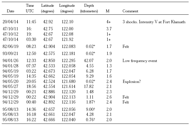
Table 3.—Seismicity in the vicinity of Crater Lake, Oregon.
Time is Coordinated Universal Time (UTC). For Pacific Standard Time, subtract 8 hours. For Pacific Daylight Time, subtract 7 hours.
* Depth fixed to an arbitrary value.
† Maximum number of iterations exceeded. Location and depth are arbitrary.
M – An estimate of the local Richter magnitude. For events after 1982, M is the coda-length magnitude Mc. For more information see Bacon and Nathenson (1996, table 2)
3 Modified Mercalli Intensity Scale V: “Felt outdoors; direction estimated. Sleepers wakened. Liquids disturbed, some spilled. Small unstable objects displaced or upset. Doors swing, close, open. Shutters, pictures move. Pendulum clocks stop, start, change rate.”
South of the area of figure 4 and ~60 km south of Crater Lake, two strong earthquakes, M = 5.9 and 6.0, occurred September 20, 1993, followed by hundreds of aftershocks during the succeeding weeks (the “Klamath Falls” earthquakes). The main events had hypocentral depths of ~9 km and apparently took place on a north-northwest-trending normal fault inclined ~45° to the northeast (Braunmiller and others, 1995). These earthquakes caused rock falls and small landslides (largest ~300 m3) from road cuts, quarries, and steep bluff faces as far as 29 km from the epicentral area (Keefer and Schuster, 1993). Subsequent to the Klamath Falls earthquakes of 1993, telemetered instruments were added to monitor ongoing seismicity (University of Washington, 1993), and locations and detection limits for earthquakes in the vicinity of Crater Lake improved. The 1993 event 38 km south of Crater Lake (fig. 4) took place a few hours after the second Klamath Falls earthquake (a magnitude 6.0) and still has a considerable uncertainty of location. The map of earthquakes in Washington and Oregon from 1872-1993 (Goter, 1994) shows a scattering of seismicity stretching northward from Klamath Falls to Crater Lake. The catalogue for these earthquakes (R. S. Ludwin, written commun., 1996) shows that they are preliminary locations of aftershocks from the 1993 Klamath Falls earthquakes as located by the Northern California Seismic Network. Subsequent work has shown that the aftershocks did not extend as far north as shown on Goter’s map (Qamar and Meagher, 1993).
In 1994 and 1995, there was a significant amount of seismicity near Crater Lake. Detection of the earthquakes of 1994 and 1995 may be partly a result of improved instrumentation, as the prior detection threshold for earthquakes that were not felt was probably at least M=3. The event of 1 January 1994, west of Crater Lake is noteworthy in having a depth of 42 km and low-frequency wave form, properties atypical of tectonic earthquakes. In May, there were two events in the vicinity of the 1947 events near Fort Klamath. In December, there were three events (two felt) just south of Crater Lake. In August of 1995, there were three more events near Fort Klamath. It is possible that the recent M=2-3 earthquakes represent a regional increase in seismicity related to the Klamath Falls earthquakes of 1993 because the number of events per year has declined each year since 1993. The area around Klamath Falls in the Klamath graben has had significantly more seismicity in the last 50 years than has Crater Lake (see list in Sherrod, 1993).
Faults with normal (mainly vertical) displacement abound in the Crater Lake region and the contiguous Basin and Range province to the east of the Cascades (fig. 1 and 4; plate 1; Pezzopane and Weldon, 1993). Most of these faults trend north–south to northnorthwest–south-southeast. Faults are more easily recognized by topographic expression in the eastern half of the area where no relatively young volcanic rocks occur. Faults cutting the youthful lava flows of the forested Cascades are less obvious because fault offsets are smaller than in the older rocks of the sparsely vegetated landscape to the east where fault scarps can be dramatically seen, as along the east side of Upper Klamath Lake (Sherrod, 1993). Young lava flows and glacial deposits in the Cascades provide an opportunity for testing whether faults are potentially active, as these materials may be datable. Offset lava flows in Crater Lake National Park and glacial moraines at the mouths of valleys on the west side of the Upper Klamath Lake basin are described below as evidence for the recent activity of a major, through-going fault zone. Little is known about the state of faults immediately east of the Cascades and we are unaware of any detailed paleoseismic studies of faults (i.e., trenching) depicted in plate 1.