
Volcano and Earthquake Hazards in the Crater Lake Region, Oregon
Landslides May Cause Large Waves on Crater Lake
Subaqueous Landslides
Geologic evidence for the rapid formation of Crater Lake caldera by catastrophic collapse during the climactic eruption of Mount Mazama indicates that most of the caldera wall dates from that time. However, the bench on the south wall, informally known as Chaski slide, wall-parallel lake-facing scarps near Garfield Peak, and similar faults mapped in the Sun Notch to Eagle Point area suggest that large blocks of the south wall have the potential to fail. Nelson and others (1988, 1994) described a landslide deposit (fig. 3 and table 6) on the lake floor from Chaski Bay to the center of the lake that apparently formed soon after the caldera collapsed and the central platform volcano erupted but before a deep lake was present. Although other probable landslide deposits in the caldera also are thought to have been subaerially deposited and overlain by lacustrine deposits (Nelson and others, 1988), there are a number of bathymetric features that may be subaqueous slide deposits (fig. 3 and table 6). Early lake deposits (c. 7,000 years ago) are thought to be gravity-flow deposits derived from landslides triggered by seismicity associated with postcaldera volcanism (Nelson and others, 1994). We have no evidence from bathymetry or seismic profiling of large subaqueous slide deposits having formed on the caldera floor since volcanism ceased; i.e., within the last ~5,000 years.
Extensive talus deposits form much of the caldera wall, particularly beneath the lake surface, and these might be prone to failure by sliding. Movement of debris down the subaqueous walls is ongoing and feeds sediment to the deep portions of the lake (Nelson and others, 1988). It appears unlikely that rapid mass movements of sufficient volume to displace the lake surface have occurred in at least the last few hundred years. There does not appear to be unequivocal evidence of high stands of the lake, or destruction of lichen or trees that might be caused by large waves (Nelson and others, 1994). Williams (1942, p. 129), however, states that “Several years ago, Gordon Hegeness, then on the ranger-naturalist staff, discovered diatomaceous earth [lake sediment] on Wizard Island, approximately 50 feet above the surface of the lake.” Assuming this report is correct, it is unclear whether this deposit formed during a high stand of the lake or was ripped up from the lake floor and deposited by a wave.
4 Available from The Nature of the Northwest Information Center, Suite 177, 800 NE Oregon Street, Portland, OR 97232-2162.
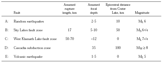
Table 5—Maximum earthquakes magnitudes in the Crater Lake region (modified after Hawkins and others, 1989).
[ML = local magnitude; MS = surface wave magnitude; MW = magnitude based on seismic moment]