
Volcano and Earthquake Hazards in the Crater Lake Region, Oregon
Regional Volcanism
Hazard Zones for Regional Volcanoes
Hazard zones delineated on plate 1 are defined on the basis of locations of volcanic vents active during the past one million years. Zone boundaries are drawn ~3 km outboard of the region of known vents on the assumption that new vents are unlikely to erupt farther than 3 km from existing volcanoes. Note that the hazard zones represent likely vent locations. The extent of lava flows or tephra falls will vary depending on eruption location (local topography), rate, and duration. Lava may flow beyond the limits of the hazard zones. The transportation corridor east of Crater Lake National Park could be disrupted by even a small tephra eruption because prevailing winds probably would carry tephra in that direction. Boundaries are straight lines because there are insufficient vents to justify more irregular shapes. Likewise, some boundaries have been drawn to coincide with county lines or to include cultural features (e.g., parts of highway 97) to minimize ambiguity in application.
Table 2.—Numbers of known basalt, basaltic andesite, and andesite volcanic vents and eruptive episodes outside Crater Lake caldera and exclusive of Mount Mazama between approximately latitudes 42° 48′ and 43° 05′
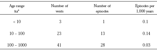
Regional Hazard Zone RH contains all vents <100,000 years in age. In the vicinity of Crater Lake, as described above, the annual probability within this zone is thought to be roughly 10-4 or a 30-year probability of 3×10⁻³. North of latitude 43°05′ and south of latitude 42°48′ within Zone RH there is less information on the history of volcanism but, nevertheless, the annual probability of an eruption is believed to be lower than in the immediate Crater Lake area. East of Zone RH is Regional Hazard Zone RL, a zone where eruption probability is considered lower than in Zone RH because it contains only vents believed to be between 100,000 and 1,000,000 years in age. Here the annual probability of an eruption occurring between latitudes 42°48′ and 43°05′ is judged to be of order 1 in 100,000, or about 10-5, or a 30-year probability of 3×10⁻⁴. Presumably, the annual probability is no greater in the parts of Zone RL north or south of the 42°48′ to 43°05′ band. Outside of these hazard zones there are no known volcanic vents younger than 1,000,000 years old and the probability of an eruption is believed to be negligible.
The probabilities quoted above are for an eruption somewhere in a regional hazard zone. As any eruptive episode will cover only a small part of the zone with lava or tephra, the probability of a given area within the zone being affected in a particular time interval is substantially less than the probability of an eruption occurring somewhere within the zone.