
Volcano and Earthquake Hazards in the Crater Lake Region, Oregon
Geologic Setting of Crater Lake
Mount Mazama and Crater Lake caldera lie at the intersection of the Cascade chain of volcanoes with the Klamath graben, a north-northwest trending basin bounded by faults whose displacement is mainly vertical (fig. 1). At this latitude, the western margin of the Basin and Range province, characterized by north-south to northwest-southeast trending faults, impinges upon the Cascades. Focusing of volcanism at Crater Lake and the development of the shallow magma chamber which fed the climactic eruption are linked to this regional tectonic situation.
North and south of Crater Lake are many shield volcanoes of modest size and many more cinder cones with associated lava flow fields. Both represent short-lived activity at isolated vents. These monogenetic volcanoes are manifestations ofregional volcanism throughout the Oregon Cascades.
Mount Mazama is the name applied to the volcano in which Crater Lake caldera formed (fig. 2). Before the caldera-forming eruption, the summit of Mount Mazama stood at ~3,700 m (~12,000 feet) elevation. Mount Mazama was constructed during the last approximately 400,000 years by episodic growth of many overlapping shield and composite volcanoes, each of which probably was active for a comparatively brief period (Bacon, 1983). The erupted magma was mainly andesite. As the volcanic complex evolved, so did its eruptive style, such that the last ~70,000 years saw more highly explosive eruptions of silicic magma (dacite and rhyodacite). In the last ~30,000 years, the only record of activity, prior to the caldera-forming climactic eruption of ~7,700 years ago, was limited to a small number of preclimactic pyroclastic eruptions and ensuing lava flows of rhyodacite. Subsequent to the climactic eruption, all volcanic activity has occurred within the caldera itself. Wizard Island is a cinder cone and lava flows of postcaldera andesite, erupted soon after the caldera formed. Several more postcaldera volcanoes are hidden by the lake (fig. 3).
The remainder of this report discusses volcano hazards1, followed by those related to earthquakes2. The most probable types of volcanic activity and their respective hazard zones are described first, namely, reawakening of Mount Mazama, eruptions in Crater Lake, lahars, and eruptions outside of the caldera. These are followed by the low probability, high consequence events of another caldera-forming eruption and sudden gas release from the lake. In subsequent sections, potential magnitudes of earthquakes are estimated and hazards of earthquake-induced landslides are evaluated. Suggestions for mitigation are given at the ends of both the volcano and earthquake hazard sections.
1 The recent book by Scarpa and Tilling (1996) contains many papers on volcano monitoring, eruptive phenomena, hazards and risk assessment, and emergency management.
2 See Wong and Bott (1995) for a useful overview of earthquakes in Oregon. VOLCANO AND EARTHQUAKE HAZARDS IN THE CRATER LAKE REGION, OREGON
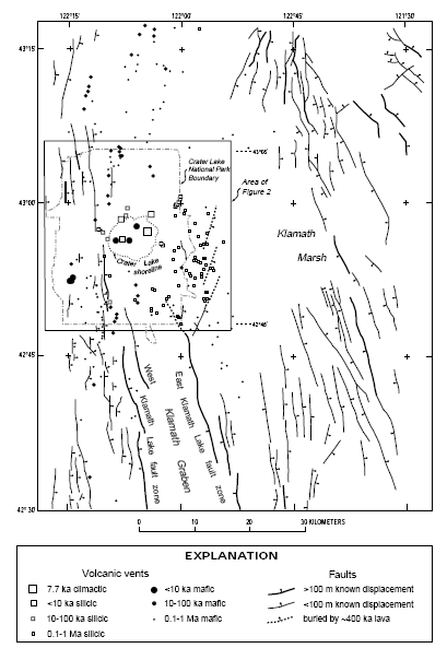
FIGURE 1.—Map showing faults and volcanic vents in the Crater Lake region (Plate 1 covers a slightly larger area at 1:100,000 scale and includes hazard zones). Data sources: Hawkins and others (1989), MacLeod and Sherrod (1992), Sherrod (1991), Sherrod and Pickthorn (1992), Smith (1988), Smith and others (1982), C. R. Bacon (unpublished mapping, 1996), and M. A. Lanphere (unpublished K–Ar ages, 1996).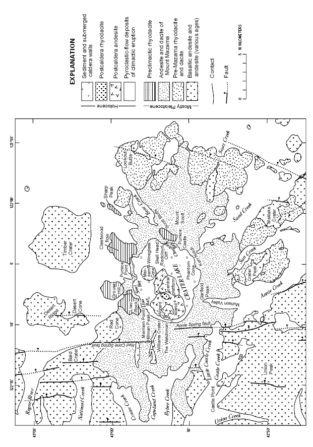
FIGURE 2.—Generalized geologic map of Mount Mazama and vicinity. Data source: C. R. Bacon (unpublished mapping, 1996).