
The Geology of Crater Lake National Park, Oregon With a reconnaissance of the Cascade Range southward to Mount Shasta by Howell Williams
The Foundations of Mount Mazama
Eocene Formations
At the dose of the Cretaceous period, the distribution of land and sea was greatly changed. The sea retreated westward beyond the line of the Cascade Range, never to return, and its place was taken by a gently undulating plain. Weaver1 suggests that uplift of the Cretaceous rocks in southwestern Oregon forced the sea even farther west than the present coast line, though to the north the recession was considerably less. During Middle Eocene time, slight downwarping of the plain permitted the sea to readvance over northwestern Oregon to a shore line that ran approximately from the vicinity of Roseburg through Portland to Seattle. Farther south, in the Klamath-Siskiyou region and in the Ashland-Medford valley, the Lower and Middle Eocene was a time of nondeposition, and it is likely that the mountains were rising isostatically in response to erosion.
Volcanic activity had already commenced in eastern Washington during the early Eocene, as is shown by the lavas and pyroclastic deposits of the Naches formation. Between Lower and Middle Eocene times volcanism increased in intensity and became more widespread. From Roseburg north to Vancouver Island, tremendous eruptions occurred. Most of the lavas were basic and many escaped from submarine fissures in the form of pillow basalts, as in the Roseburg region, 40 miles west of Crater Lake. Accompanying the flows were explosions of fragmental debris, so that the sediments accumulating in the Eocene seas were highly charged with tuff.
A shallow marine embayment continued to occupy most of northwestern Oregon in Upper Eocene times, its southern limit following a line westward from Roseburg to the present coast. Farther south, between Roseburg and the head of Evans Valley (see map, plate 2), Eocene sediments seem to be absent. This appears to have been a region of continuous erosion throughout the Eocene period. But still farther south, from Evans Valley, through the Ashland-Medford ‘valley, as far as Shasta Valley in California, 60 miles distant, there is an unbroken belt of Upper Eocene sediments, referred to as the Umpqua formation.
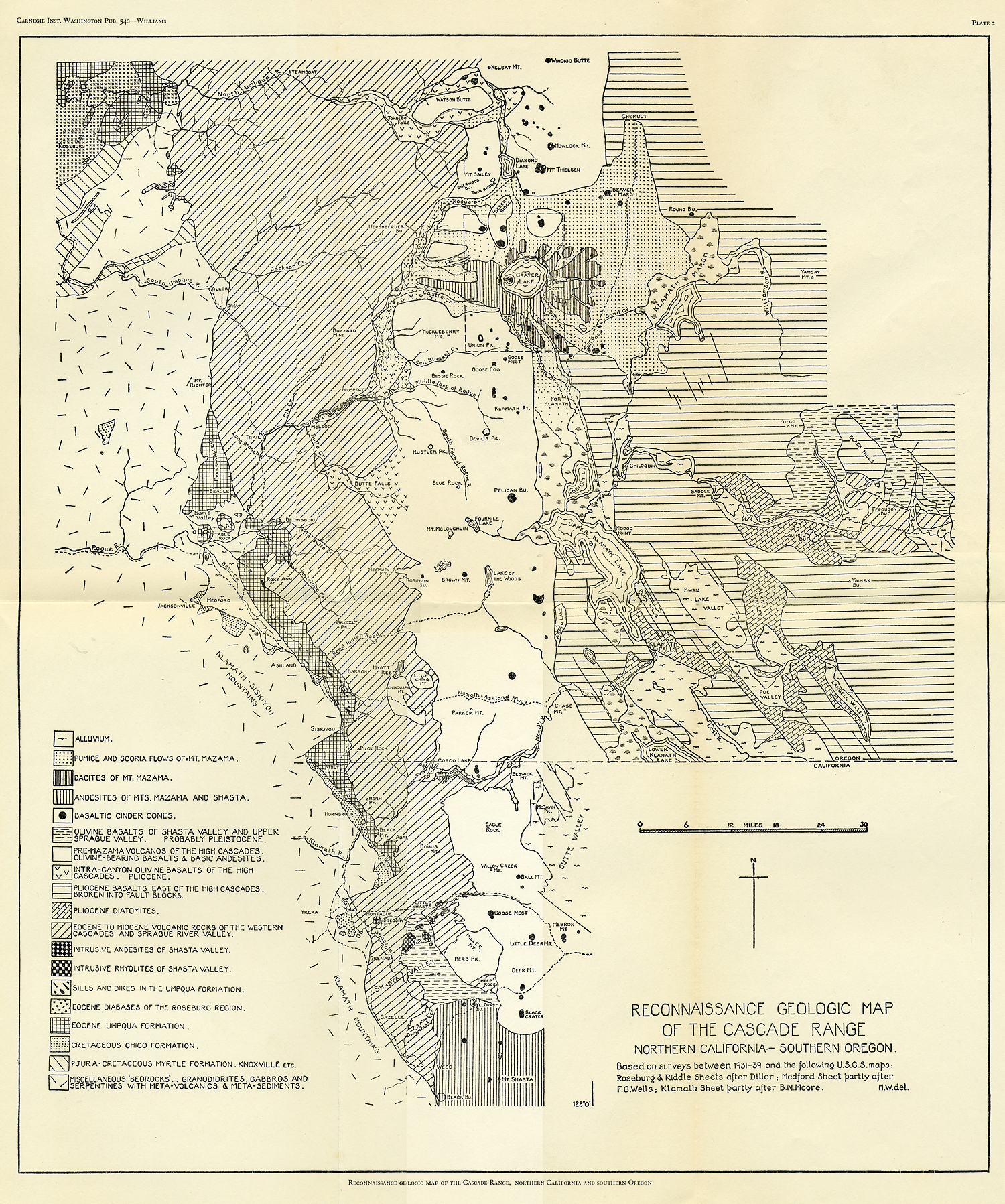
Plate 2
However, unlike the Umpqua formation of the Roseburg area, which is entirely marine, the Umpqua here is largely, if not wholly, of fresh-water origin.
The fresh-water Umpqua formation rests disconformably and perhaps in part with slight angular unconformity on the Chico formation in this southern belt. According to Wells,2 it attains a maximum thickness of about 8000 feet in the Medford quadrangle. In Evans Valley, it rests directly on the bedrocks and consists mainly of arkosic sands with pebbly layers, shales, and several thin seams of coal. Around Beagle, in Sams Valley, and under the lava cappings of Table Rock, the Umpqua marls and sands, largely derived from acid plutonic bedrocks, carry abundant fragments of silicified wood. In the Ashland-Medford valley, where the formation reaches its fullest development, the sediments are chiefly sandstones, shales, and conglomerates, the latter heavily charged with pebbles and boulders of quartzite, milky quartz, and chert. In the upper part of the formation, volcanic material becomes increasingly abundant. It is therefore impossible to draw any sharp boundary between the Umpqua and the overlying Western Cascade volcanic series. Close to the Rogue River, the transitional water-laid volcanic detritus reaches a thickness of 2000 feet.