
The Geology of Crater Lake National Park, Oregon With a reconnaissance of the Cascade Range southward to Mount Shasta by Howell Williams
The Foundations of Mount Mazama
Earth Movements of the Close of the Miocene
Earth movements had already occurred prior to the beginning of the volcanic activity that built the Western Cascades; they may indeed have been responsible for the onset of volcanism. In the Roseburg area, the basal volcanics lie with marked angular unconformity on the marine Eocene (Umpqua) formation. North of Talent, in the Ashland-Medford valley, the basal volcanics rest conformably on the fresh-water Umpqua beds; to the south a strong discordance separates them.
It is likely also that once volcanic activity commenced, earth movements were recurrent. To the east of the Cascades, the evidence is clear, for the John Day beds are separated by unconformities both from the Columbia River lavas above and from the Clarno formation below. Within the Western Cascades themselves the evidence is less conclusive, for it is difficult to be sure whether angular discordances are a sign of diastrophism or merely the result of overlapping among lenticular volcanic deposits from different sources.
Major earth movements certainly affected the entire volcanic region at the close of the Miocene. It was at this time that the Western Cascade series, in the belt extending northward from Shasta Valley to Medford, acquired its easterly and northeasterly dips. The highest dips, approximately 15°, normally occur among the basal, westernmost rocks, and in general the dips flatten gradually toward the east until, near the margin of the High Cascades, the beds lie either horizontally or almost so. Perhaps this westward increase in the amount of deformation reflects a major uplift of the bedrocks in the Klamath Mountains and the region immediately to the north.
North of the Rogue River, the general trend of the Western Cascades changes to approximately north-south in response to a gradual change in the dips from northeast to east. The dominant eastward dip continues as far north as the Santiam River, where the axes of the folds swing to a northeasterly direction and so continue to the Columbia River. In this northern part of Oregon, as Thayer has shown,15 the pre-Pliocene volcanics are thrown into a series of broad anticlines and synclines. East of the Cascades, between Bend and the Columbia River, the folds and faults have, according to Hedge,16 a roughly east-west trend and thus cut athwart the Cascade Range.
It was probably during or shortly after this period of folding that many of the dioritic intrusions of the Western Cascades were formed. These and the mineralized sulphide areas associated with them follow the trend of the Cascade Range, running in a northnortheast direction north of the Bohemia mining district and north-northwest south of it. The quicksilver belt farther west is roughly parallel.
Accompanying the folding and intrusions at the close of the Miocene, or perhaps a little later, the north-south fracture system-of the High Cascades began to develop. West of Mount Jefferson, the High Cascade lavas abut on an eastward-facing fault scarp cut across the Western Cascade rocks. Thayer17 believes that before the High Cascade lavas were erupted this scarp was at least 2000 feet high, and that the rise of the block to the west gave the Western Cascades their present elevation. In the region west and southwest of Crater Lake, there is physiographic evidence of a discontinuous, approximately north-south series of faults separating the Western from the High Cascades (see sections, figure 3). West of the contact, the older lavas rise to heights of more than 5000 feet; immediately to the east they lie buried beneath High Cascade lavas at elevations of less than 3000 to 4000 feet. This sudden fall in elevation seems best explained on the assumption of concealed faults with large downthrow to the east.
Still farther south, from Butte Falls to Shasta Valley (see map, plate 2) there is no clear evidence of buried faults; certainly none separates the High from the Western Cascade lavas in the gorge of the Klamath River.
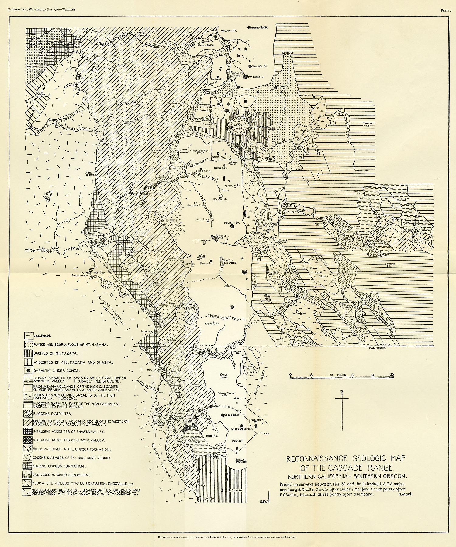
Plate 2
As a result of these disturbances at the close of the Miocene, the Cascades became a high and rugged range, shutting off eastern Oregon from the supply of moisture-bearing winds so that the redwood ceased to grow there and a vegetation not unlike that of today took its place. Perhaps as the Western Cascades were being uplifted, rapid downcutting permitted the principal streams to maintain a westward course, even against the dips of the rocks they traversed, for if the Klamath, the Rogue, and the Umpqua are not antecedent streams it is difficult to account for the manner in which the present mountains.
***previous*** — ***next***