
The Geology of Crater Lake National Park, Oregon With a reconnaissance of the Cascade Range southward to Mount Shasta by Howell Williams
The Foundations of Mount Mazama
The High Cascades Between Mounts Shasta and Mazama
The Volcanic Cones
For the purpose of discussion, the northernmost of the High Cascade volcanoes shown on the map (plate 2) will be described first. Those to the south will then be referred to in turn.
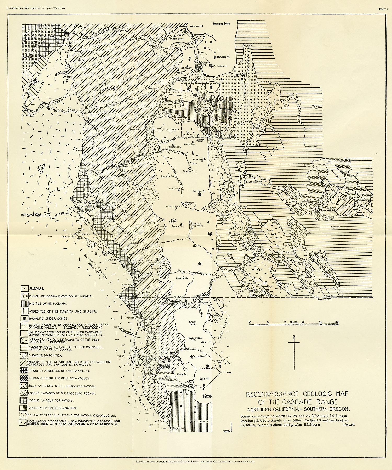
Plate 2
The oldest High Cascade volcanoes to the north of Crater Lake are Watson Butte and Pig Iron Mountain, which coalesce and form an island among flat-topped intracanyon basalts. Obviously these volcanoes had already been deeply denuded before the surrounding basalts were erupted. One of the vents lay near the summit of Watson Butte, where the lavas are associated with tuff breccias and are intruded by many small dikes of dark-green olivine basalt.
Nearer Crater Lake lie the younger cones of Howlock Mountain, Mount Thielsen, and Mount Bailey, the last of which has suffered least from erosion. The flanks of the other two have been excavated into large glacial cirques, and dissection has proceeded far enough to reveal the central conduits. Probably the main activity at all three volcanoes ceased early in the Pleistocene period, while Mount Mazama was still in its infancy, though parasitic flank eruptions built several small cinder cones much later.19
Still closer to the northern boundary of the National Park lie the small basaltic cones of Sherwood Buttes and Twin Knobs. These, like the basaltic volcano of Desert Ridge, which falls partly within the park and is therefore described more fully below, have lost their original craters, and their sides have been greatly modified by glacial action.
South of Crater Lake, the High Cascades form a broad plateau built by the confluence of lavas from many basaltic shields. The plateau is incised by glacial cirques and valleys, and most of the shields, though still preserving their general outlines, have been deeply eroded and have lost their summit craters.
Closest to Mount Mazama is the large volcano that culminates in Union Peak, to be described in detail later. The main vent of the volcano may already have become extinct before Mount Mazama commenced to form, but parasitic eruptions occurred on the southeast slope long afterward.
The vent of one of the largest of the basaltic volcanoes lay immediately to the north of Devil’s Peak, on the precipitous north side of which may be seen the remains of a tuff-scoria cone, cut by basaltic dikes. This ruined cone once occupied the summit crater of the volcano. Lavas from this source spread across the full width of the High Cascades. Smaller parasitic cones rose not far from Devil’s Peak, on Klamath Point and elsewhere.
Another prominent basaltic shield volcano forms Rustler Peak, on the top of which stands a symmetrical dome of pale hornblende andesite. So far as is known, this andesite is the only lava in the entire stretch of the High Cascades between Mounts Shasta and Mazama that relieves the monotony of the olivine basalts and basic pyroxene andesites; and this is the only domical protrusion yet recognized in that stretch of 80 miles.
The next vent toward the south lies near Blue Rock. Here, flows of basalt radiate from a central plug of olivine diabase around which are clustered many dikes of dark-green olivine basalt similar to those seen on Watson Butte. The summit crater of the Blue Rock volcano has been completely obliterated.
East of Blue Rock, and towering above the Klamath graben, is a much younger basaltic volcano, Pelican Butte, crowned by a well preserved cinder cone.
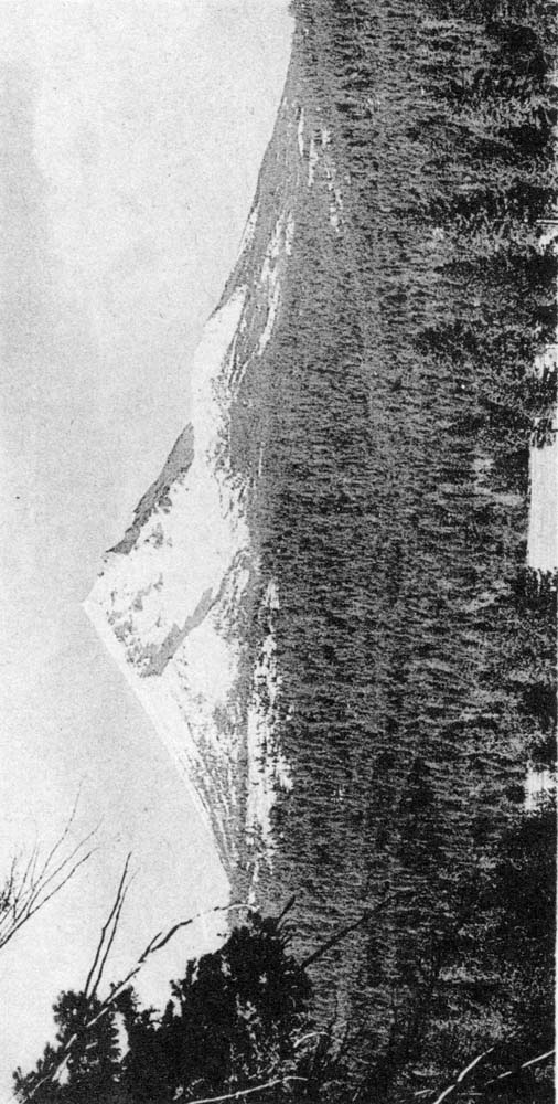
The highest of the volcanoes between Mounts Shasta and Mazama is Mount McLoughlin, formerly known as Mount Pitt, which reaches an elevation of 9493 feet and has a basal diameter of approximately 6 miles. (See plate 5, figure I.) The lavas of this volcano are somewhat more siliceous and must have been more viscous than the basalts of the neighboring volcanoes, for the slopes of the mountain are much steeper. Toward the summit the lavas become increasingly dark and scoriaceous, as they do on many other Cascade volcanoes, indicating a higher gas content in the later flows. Toward the summit, also, the proportion of interbedded fragmental debris increases. The vent of the McLoughlin volcano lay a little to the north of the present summit, and its position is marked by the ruins of a tuff-scoria cone into which are intruded irregular vertical plugs reminiscent of those cutting the summit tuff cones on Union Peak and Mount Thielsen. In and around the vent there is evidence of much solfataric activity. The most recent flow from Mount McLoughlin, a blocky olivine basalt, escaped from a fissure at the northwest base probably not more than a few centuries ago.
|
Plate 5. Fig. 1. Mount McLoughlin from the north. The vent of the volcano lies near the head of the glacial cirque, below the summit of the peak. (Photograph by H. B. Taylor.) |
Adjacent to Mount McLoughlin is one of the youngest and best preserved of all the basaltic volcanoes of the High Cascades, Brown Mountain, a perfect shield, some 2000 feet high, topped by a youthful cinder cone. The sides of this volcano are a veritable wilderness of blocky olivine basalt flows so fresh in appearance, so steep-fronted, and for the most part so thinly covered with vegetation that they can hardly be more than a few hundred years old. Robinson Butte, to the west of Brown Mountain, is an older basaltic shield, and its summit cinder cone has almost entirely disappeared.
Between these volcanoes and the Oregon-California line stretches a basaltic plateau dotted with wooded shield volcanoes of Icelandic type. These merit no particular attention; their parasitic and summit cinder cones are shown on the map (plate 2). They consist of extremely uniform pale-gray olivine basalt.
Detached from the main belt are the twin volcanoes of Chinquapin and Little Chinquapin mountains, also made up of homogeneous flows of olivine basalt. At the south base of Little Chinquapin, the underlying lavas of the Western Cascade series are cut by a swarm of dikes trending north north east, perpendicular to the strike. The position of these two isolated volcanoes seems to be related to a local flexure in the underlying rocks.
Owing to the cover of vegetation, there is little to be seen on the slopes of the shield volcanoes between the Ashland-Klamath Falls highway and the gorge of the Klamath River, but in the walls of the gorge sheets of basalt, averaging 20 to 25 feet thick, are exposed to a depth of more than 1000 feet, lying almost horizontally on eastward-dipping andesites and rhyolites of the Western Cascade series. Apparently a broad and shallow valley already existed along the course of the Klamath River when the neighboring shield volcanoes erupted this succession of flows.
A most interesting field of recent volcanism and one that will repay closer study lies immediately below Copco Lake on the Klamath River. Here, probably within the past thousand years, three basaltic cinder cones were formed along a north-south fissure and from them flows of scoriaceous olivine basalt were erupted. These dammed the Klamath River to form a deep lake, in which much diatomaceous earth accumulated. Accompanying the basic flows, there were protrusions of hornblende dacite in the form of domes and intrusions of columnar basalt.
A north-south cluster of basaltic and basic andesite volcanoes makes up the High Cascades between the Klamath River and Mount Shasta. The older ones, including Herd Peak, Willow Creek Mountain, Eagle Rock, and Ball Mountain, though retaining their topographic individuality, are devoid of summit craters and may date back to the Pliocene period, whereas the younger ones, including Black Crater and the Goose Nest, continued their activity until quite recently. On the flanks of several of these volcanoes are youthful cinder cones (see map, plate 2). East of the main belt rise many more basaltic shields that differ only in being greatly modified by faulting. These merge gradually into a basaltic plateau, capped by recent cones, that stretches eastward to the Medicine Lake Highlands.
Finally, at the south end of the belt rises the magnificent Mount Shasta, a composite cone built up, like Mount Mazama, chiefly of hypersthene andesite and, like the latter, containing far more pyroclastic ejecta than any of the volcanoes that lie between. The similarity between the two is accentuated by the fact that both, in the later stages of activity, erupted viscous flows and domes of dacite and cones of basaltic scoria. At Shasta, these culminating eruptions took place mainly from a north-south fissure traversing the summit, parallel to the main axis of the High cascades. 20
***previous*** — ***next***