
The Geology of Crater Lake National Park, Oregon With a reconnaissance of the Cascade Range southward to Mount Shasta by Howell Williams
The Glaciation of Mount Mazama
Evidences of Early Glaciation on the Caldera Walls
West Wall of the Caldera, from Llao Rock to Eagle Cove
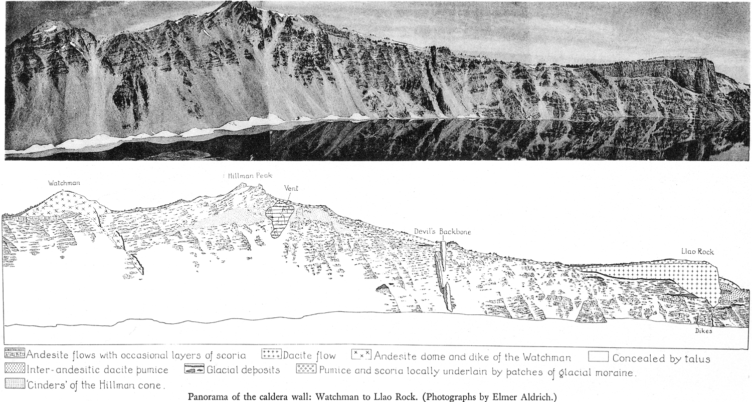
Plate 29. Panorama of the caldera wall: Watchman to Llao Rock. (Photographs by Elmer Aldrich.)
The oldest glacial deposit in this part of the walls lies a short distance south of the Devil’s Backbone, approximately 300 feet above the lake (panorama, plate 29). The eye accustomed to the particular shade of gray that most of the tills exhibit has no difficulty in distinguishing it even from afar. When Atwood first discovered the occurrence, he noted glacial striae trending north 65° west on the underlying lava, but these are no longer visible.
On the west and southwest sides of the caldera, the topmost till is absent only on the highest points of the rim, such as Hillman Peak and the Watchman. Presumably these eminences were never covered by ice. Beneath this youngest till there are many beautifully striated surfaces of lava. In the col between the Watchman and Discovery Point, approximately due west from the top of Wizard Island, A. E. Long discovered the partly carbonized stump of a tree in the position of growth at the Contact of the till with the overlying pumice. Across the top, the stump measured 13 1/2 inches; across the bottom, 15 1/2 inches; its length was 52 inches. The lowest 8 inches of the stump had not been carbonized, but the rest had been burned by the hot pumice. The discovery is important not only because it proves that vegetation existed at this elevation on the volcano just before the destruction of the summit, but also since it implies that a long period of quiescence preceded the last, catastrophic explosions.
A short distance south of this locality, the youngest till is both underlain and overlain by dacite pumice. Generally, however, the till rests directly on the striated surface of a thick flow of andesite, which lies in turn on a second layer of till. Below this is a second thick flow of lava. Then follows a conspicuous layer of pink pumice, and finally a third lens of till, between 50 and 60 feet thick, approximately 500 feet above the lake. The wall below is entirely made up of thin sheets of andesite.
Near Discovery Point, one may stand on the polished surface of the topmost lava and look down 40 feet to the striated crust of an older lava overlain by 10 feet of till. At Glacier Point, about 1 1/2 miles to the south, a succession of three tills, each overlying striated lava, may be seen within 150 feet of the caldera rim. These occurrences have already been described and illustrated by Atwood.3
Space precludes a detailed discussion, but it may be noted that at several other places on the west and southwest walls of the caldera many lenses of glacial till occur within a few hundred feet of the rim. An excellent section is exposed just inside the rim, about 150 yards south of the Devil’s Backbone. Here, beneath the youngest till and its overburden of pumice, lie older deposits of pumice up to 30 feet in thickness, and beneath these a band of coarse, bouldery till no less than 120 feet thick, which rests on a striated surface of andesite. From the sandier layers in the till, water oozes continually.
The youngest till reaches its greatest development in the saddle between the Lake Trail and Crater Lake Lodge. It may be seen to advantage from the parapet of the Sinnott Memorial. The morainic deposits here reach a thickness of more than 120 feet. Worthy of particular note is the fact that there is no cover of pumice. This moraine is in fact a relic of the Munson glacier, which at the time of the destruction of Mount Mazama still extended as far south as the Government Headquarters, 1 1/2 miles beyond the rim of the caldera.
***previous*** — ***next***