
The Geology of Crater Lake National Park, Oregon With a reconnaissance of the Cascade Range southward to Mount Shasta by Howell Williams
The Earlier Dacite Eruptions
The Eastern Cluster of Domes and Flows
At the eastern foot of Mount Scott, and extending thence downward to the plateau bordering the Dalles-California highway, there is a remarkable group of domes. In an area of approximately 25 square miles, a dozen or more steep-sided symmetrical buttes may be seen, and the geologist, viewing them from a distance, might well be pardoned if he mistook them for basaltic cinder cones (plate 9, figure 2). They are, however, protrusions of Pelean type.
|
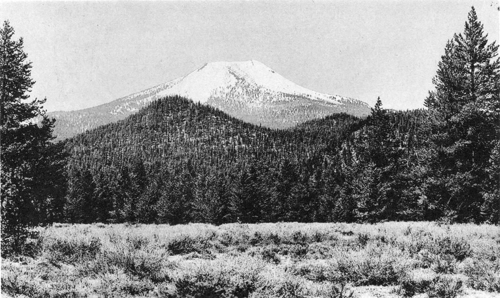
Plate 9. Fig. 2. Mount Scott and parasitic domes, looking west from the Dalles-California highway, From no other angle does the cone of Scott appear so symmetrical (compare figure 1, above). The wooded hills in the middle distance are younger dacite domes. (Photograph by H. B. Taylor.) |
Several of the protrusions, such as Lookout, Pothole, and Dry buttes, stand isolated on platforms of dacite, but most of them, as figure 6 shows, occur in clusters. A few seem to be arranged along fissures which are radial with respect to the cone of Mount Mazama, but the majority show no systematic alignment. Those within or close to the park boundary appear to be a little older than those at lower elevations, though none seems to have suffered from glaciation. Indeed, the perfection of their forms and the steep fronts of the lava flows associated with them indicate that they are among the latest manifestations of activity at Mount Mazama prior to the destruction of its submit. There is no accurate criterion by which to judge their age with respect to the dacites erupted from the Northern Arc of Vents, such as the Llao Rock and Cleetwood flows, but from the degree to which they have been eroded it seems safe to say that they are not much older.
The eastern domes range between 1/2 and I mile in diameter, and between 500 and 1000 feet in height. The southernmost, Dry Butte, consists of hornblende andesite, but the others are chiefly composed of friable, almost pumiceous gray pyroxene dacite, like the associated flows.
On most of the domes, solid outcrops are restricted to the topmost crags and even in these there is usually too little flow banding to suggest the internal structure. On 5433 Hill, however, the crags on the south side show that near the base the banding generally either is flat or dips inward at low angles; higher up the banding steepens, and at the top it is commonly vertical. In other words, the banding on this dome is crudely fan-shaped. On Lookout Butte also, the summit crags exhibit steep flow planes. Pothole Butte may represent a domical protrusion that rose from the vent through which the underlying flow of dacite was erupted. The relations here recall those to be described on Grouse Hill (page 49). The line of small buttes immediately northwest of Bear Butte represents three distinct protrusions along a common fissure directed toward the central vents of Mount Mazama.
Approximately 4 miles southeast of this large cluster of domes, and close to the base of Boundary Butte, there is an isolated hillock of dacite, sometimes referred to as Egan Spring Butte (figure 6). A thick blanket of pumice makes it impossible to determine the internal structure. The surface, however, is littered with large subangular blocks of vesicular dacite. Presumably, therefore, the hillock represents another small domical protrusion. Judging solely by its form, it seems to be of about the same age as Boundary Butte and the other basaltic scoria cones not far away. If so, basic and acid magmas were erupted from closely spaced vents in quick succession.
|
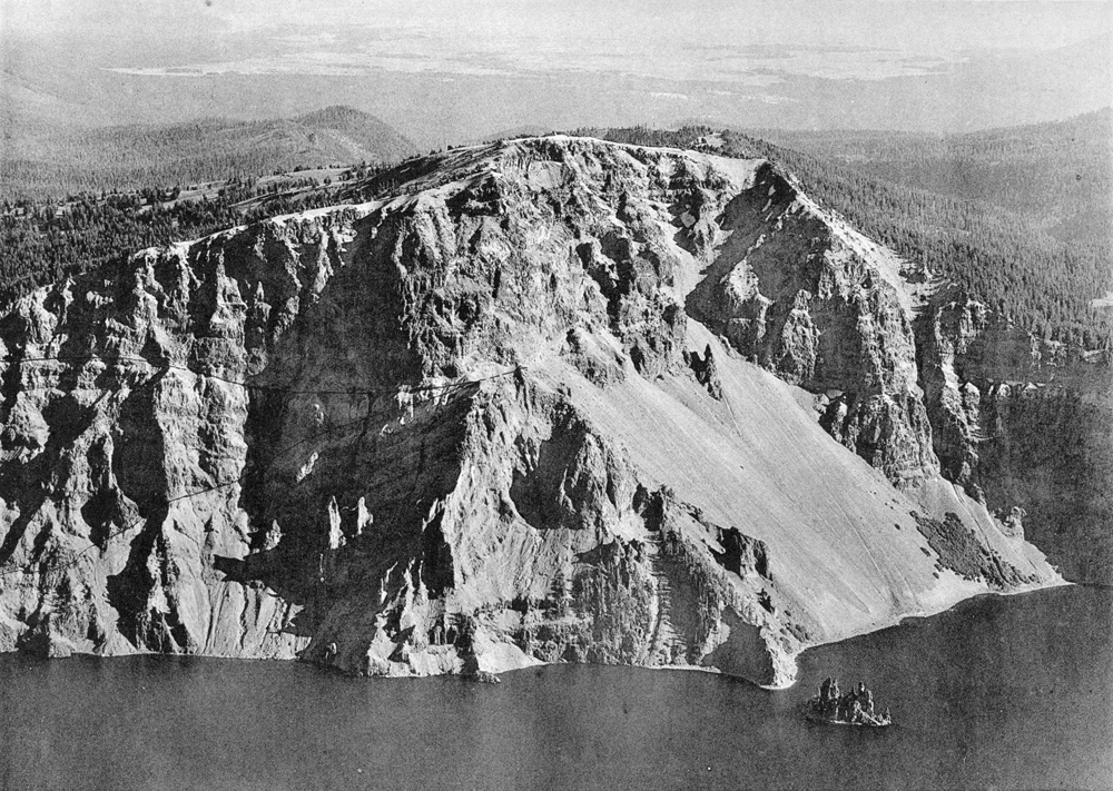
Plate 6. Dutton Cliff and Phantom Ship. The triangular cliff in the center of the picture is the filling of a vent, possibly the oldest on Mount Mazama. From this, the Phantom Cone was built, of which Phantom Ship is part. The lakeward dips of the lavas and breccias of this cone are clearly shown. After extinction, the Phantom Cone was eroded and then buried by flows from the main vents of Mount Mazama. Note unconformity on the east (left) side between the Phantom and Mazama lavas. A second unconformity, among the Mazama flows, appears higher up the cliff. Thin glacial deposits occur at this horizon, and water seeps issue from them. (Photograph by U. S. Army Air Corps.) |
***previous*** — ***next***